Maps of Tisová

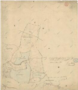
Katastrální mapa obce Tisová s osadou Trnová
1 : 2880
Tissa - c7919-1-003 - Kaiserpflichtexemplar der Landkarten des stabilen Katasters
1 : 2880
Tissa - c7919-1-002 - Kaiserpflichtexemplar der Landkarten des stabilen Katasters
1 : 2880
Tissa - c7919-1-001 - Kaiserpflichtexemplar der Landkarten des stabilen Katasters
1 : 2880
Tissa - c7919-1-005 - Kaiserpflichtexemplar der Landkarten des stabilen Katasters
1 : 2880
Tissa - c7919-1-004 - Kaiserpflichtexemplar der Landkarten des stabilen Katasters
1 : 2880
Přehledová mapa dvorů Tisová a Trnová
1 : 6011
Gamnitz - c2820-1-002 - Kaiserpflichtexemplar der Landkarten des stabilen Katasters
1 : 2880
Gamnitz - c2820-1-001 - Kaiserpflichtexemplar der Landkarten des stabilen Katasters
1 : 2880
Gamnitz - c2820-1-005 - Kaiserpflichtexemplar der Landkarten des stabilen Katasters
1 : 2880
Gamnitz - c2820-1-003 - Kaiserpflichtexemplar der Landkarten des stabilen Katasters
1 : 2880
Gamnitz - c2820-1-004 - Kaiserpflichtexemplar der Landkarten des stabilen Katasters
1 : 2880
Gumplitz (Gumplice) - c3692-1-001 - Kaiserpflichtexemplar der Landkarten des stabilen Katasters
1 : 2880
Gumplitz (Gumplice) - c3692-1-002 - Kaiserpflichtexemplar der Landkarten des stabilen Katasters
1 : 2880
Gumplitz (Gumplice) - c3692-1-004 - Kaiserpflichtexemplar der Landkarten des stabilen Katasters
1 : 2880
Gumplitz (Gumplice) - c3692-1-003 - Kaiserpflichtexemplar der Landkarten des stabilen Katasters
1 : 2880
Hospodářská mapa revíru Kočov
1 : 11520
Přehledová mapa velkostatku Tachov
1 : 17280
[Kartenblatt]
1 : 25000 Planá (Tachov, Česko : oblast) Reichsamt für Landesaufnahme
III. vojenské mapování 4049/4
1 : 25000

Gradkartenblatt
1 : 25000 Tachov-oblast (Česko) Bulla, Eduard
Hospodářská mapa revíru Kočov
1 : 4350

Uibersichtskarte der Herrschaft Tachau
Tachov-oblast (Česko) Waraus, E. André Verlag des böhm. Forstvereins
Hayder Vicariat
Bor-oblast (Tachov, Česko)
Přehledová mapa velkostatku Tachov
1 : 17280
Stříbro a okolí
1 : 75000 Stříbro (Česko : oblast) Vojenský zeměpisný ústav
Mariánské Lázně
1 : 75000 Chodová Planá (Česko : oblast) Vojenský zeměpisný ústav
Mariánské Lázně
1 : 75000 Mariánské Lázně (Česko : oblast) Vojenský zeměpisný ústav