Maps of Obora

Katastrální mapa obce Lučina WC-XVI-19 ai
1 : 2880
Katastrální mapa obce Milíře
1 : 2880
Záměrná mapa parcel obce Obora
1 : 2880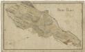
Mapa revíru Milíře
1 : 11257
Porostní mapa revíru Obora
1 : 11520
Tiergarten - c5353-1-001 - Kaiserpflichtexemplar der Landkarten des stabilen Katasters
1 : 2880
Tiergarten - c5353-1-006 - Kaiserpflichtexemplar der Landkarten des stabilen Katasters
1 : 2880
Tiergarten - c5353-1-004 - Kaiserpflichtexemplar der Landkarten des stabilen Katasters
1 : 2880
Tiergarten - c5353-1-005 - Kaiserpflichtexemplar der Landkarten des stabilen Katasters
1 : 2880
Tiergarten - c5353-1-002 - Kaiserpflichtexemplar der Landkarten des stabilen Katasters
1 : 2880
Tiergarten - c5353-1-003 - Kaiserpflichtexemplar der Landkarten des stabilen Katasters
1 : 2880
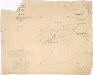
Sorghof - c4288-2-003 - Kaiserpflichtexemplar der Landkarten des stabilen Katasters
1 : 2880
Sorghof - c4288-2-004 - Kaiserpflichtexemplar der Landkarten des stabilen Katasters
1 : 2880
Sorghof - c4288-2-005 - Kaiserpflichtexemplar der Landkarten des stabilen Katasters
1 : 2880
Sorghof - c4288-2-002 - Kaiserpflichtexemplar der Landkarten des stabilen Katasters
1 : 2880
Sorghof - c4288-2-001 - Kaiserpflichtexemplar der Landkarten des stabilen Katasters
1 : 2880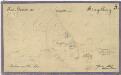
Mapa prodaných, směněných a darovaných pozemků v katastru obce Horní Výšina
1 : 2880
Porostní mapa revíru Jalový Dvůr (Branka)
1 : 11520
Porostní mapa revíru Obora
1 : 11520
Porostní mapa revíru Jalový Dvůr (Branka) a Horní Výšina
1 : 11520
Přehledová mapa velkostatku Tachov
1 : 17280
Hospodářská lesní mapa panství Tachov - část Obora

Přehledová mapa velkostatku Tachov
1 : 17280
III. vojenské mapování 4049/3
1 : 25000
Přehledná mapa panství Planá
1 : 25000
[Kartenblatt]
1 : 25000 Halže (Česko) Reichsamt für Landesaufnahme
Přehledová mapa revírů Horní Výšina, Jalový Dvůr, Obora, Milíře, Pavlův Studenec, Zlatý Potok, Nový Losimtál
1 : 22942
Lesní přehledová mapa velkostatku Tachov
1 : 29327
Lesní přehledová mapa velkostatku Tachov
1 : 20173