Maps of Hošťka

Přehledová mapa velkostatku Tachov
1 : 5747
Hospodářská mapa polesí Žebráky
1 : 5760
Porostní mapa revíru Žebráky
1 : 11520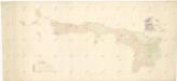
Mapa obce Žebráckého Zďáru
1 : 2603
Katastrální mapa obce Žebráky
1 : 2880
Katastrální mapa obce Žebráky
1 : 2880
Katastrální mapa obce Nový Losimtál ZS-XVI-21 bf
1 : 2880
Petlarn - c9379-1-006 - Kaiserpflichtexemplar der Landkarten des stabilen Katasters
1 : 2880
Petlarn - c9379-1-002 - Kaiserpflichtexemplar der Landkarten des stabilen Katasters
1 : 2880
Petlarn - c9379-1-007 - Kaiserpflichtexemplar der Landkarten des stabilen Katasters
1 : 2880
Petlarn - c9379-1-005 - Kaiserpflichtexemplar der Landkarten des stabilen Katasters
1 : 2880
Petlarn - c9379-1-001 - Kaiserpflichtexemplar der Landkarten des stabilen Katasters
1 : 2880
Petlarn - c9379-1-004 - Kaiserpflichtexemplar der Landkarten des stabilen Katasters
1 : 2880
Petlarn - c9379-1-003 - Kaiserpflichtexemplar der Landkarten des stabilen Katasters
1 : 2880
Neuhäusl - c5260-1-002 - Kaiserpflichtexemplar der Landkarten des stabilen Katasters
1 : 2880
Neuhäusl - c5260-1-001 - Kaiserpflichtexemplar der Landkarten des stabilen Katasters
1 : 2880
Neuhäusl - c5260-1-004 - Kaiserpflichtexemplar der Landkarten des stabilen Katasters
1 : 2880
Neuhäusl - c5260-1-005 - Kaiserpflichtexemplar der Landkarten des stabilen Katasters
1 : 2880
Neuhäusl - c5260-1-003 - Kaiserpflichtexemplar der Landkarten des stabilen Katasters
1 : 2880
Katastrální mapa obce Žebráky
1 : 2880
III. vojenské mapování 4149/1
1 : 25000
Porostní mapa revíru Jedlina
1 : 11520
Hospodářská mapa revíru Jedlina II. sekce
1 : 5760
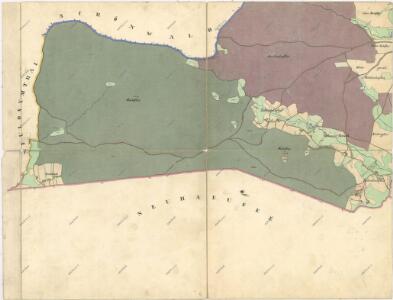
Schönwald - c3869-2-004 - Kaiserpflichtexemplar der Landkarten des stabilen Katasters
1 : 2880
Schönwald - c3869-2-002 - Kaiserpflichtexemplar der Landkarten des stabilen Katasters
1 : 2880
Schönwald - c3869-2-001 - Kaiserpflichtexemplar der Landkarten des stabilen Katasters
1 : 2880
Schönwald - c3869-2-006 - Kaiserpflichtexemplar der Landkarten des stabilen Katasters
1 : 2880
Schönwald - c3869-2-008 - Kaiserpflichtexemplar der Landkarten des stabilen Katasters
1 : 2880
Schönwald - c3869-2-003 - Kaiserpflichtexemplar der Landkarten des stabilen Katasters
1 : 2880
Schönwald - c3869-2-005 - Kaiserpflichtexemplar der Landkarten des stabilen Katasters
1 : 2880