Maps of Manětín

Katastrální mapa města Rabštejn
1 : 2880
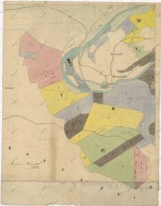
Hospodářská mapa polesí Vranov
1 : 4320
Hospodářská mapa polesí Vranov
1 : 4320
Porostní mapa polesí Rabštejn
1 : 5760
Rabenstein (Wranow) - c6299-1-001 - Kaiserpflichtexemplar der Landkarten des stabilen Katasters
1 : 2880
Rabenstein (Wranow) - c6299-1-004 - Kaiserpflichtexemplar der Landkarten des stabilen Katasters
1 : 2880
Rabenstein (Wranow) - c6299-1-003 - Kaiserpflichtexemplar der Landkarten des stabilen Katasters
1 : 2880
Rabenstein (Wranow) - c6299-1-005 - Kaiserpflichtexemplar der Landkarten des stabilen Katasters
1 : 2880
Rabenstein (Wranow) - c6299-1-002 - Kaiserpflichtexemplar der Landkarten des stabilen Katasters
1 : 2880
Kottanschen (Kotanec) - c3410-1-001 - Kaiserpflichtexemplar der Landkarten des stabilen Katasters
1 : 2880
Kottanschen (Kotanec) - c3410-1-002 - Kaiserpflichtexemplar der Landkarten des stabilen Katasters
1 : 2880
Katastrální mapa obce Kotaneč WC-IX-16 ah ai
1 : 2880
Hospodářská mapa polesí Rabštejn-Kalec část Kuchynka
1 : 2880
Hospodářská mapa polesí Rabštejn-Kalec
1 : 11520
[Kartenblatt]
1 : 25000 Rabštejn nad Střelou (Manětín, Česko : oblast) Reichsamt für Landesaufnahme

III. vojenské mapování 3950/4
1 : 25000
Gradkartenblatt
1 : 25000 Žlutice-oblast (Česko) Brück, Josef
Přehledná mapa velkostatku Manětín podle stavu k roku 1905
1 : 37500
Generální mapa lesů velkostatku Plasy
1 : 13186
Situační plán hájoven náležejících k panství Plasy
1 : 25000
Teusinger Vikariat
Toužim-oblast (Česko)
Karlovy Vary
1 : 75000 Bochov (Česko : oblast) Vojenský zeměpisný ústav
[Umgebung von Kralowitz]
1 : 75000 Kralovice (Plzeň-sever, Česko : oblast) K. u. k. Militärgeographisches Institut
Kralovice a okolí
1 : 75000 Kralovice (Plzeň-sever, Česko : oblast) Vojenský zeměpisný ústav
Karlovy Vary
1 : 75000 Karlovy Vary-oblast (Česko) Vojenský zeměpisný ústav
III. vojenské mapování 3950
1 : 75000
Podrobná mapa Království českého
1 : 100000 Kralovice (Plzeň-sever, Česko : oblast) Srp, Jan Jaroslav Bursík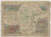
Plassii maioris olim possessio
Plasy-oblast (Česko) Babánek, František Schwihlik, F.