Maps of Žihle

Katastrální mapa obce Kotaneč
1 : 2880
Kottanschen (Kotanec) - c3410-1-001 - Kaiserpflichtexemplar der Landkarten des stabilen Katasters
1 : 2880
Kottanschen (Kotanec) - c3410-1-002 - Kaiserpflichtexemplar der Landkarten des stabilen Katasters
1 : 2880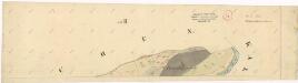
Katastrální mapa obce Vysočany
1 : 2880
Hospodářská mapa katastrálního území Vysočany
1 : 2880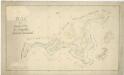
Hospodářská mapa polesí Vranov
1 : 4320
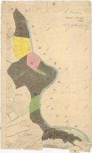
Kalletz (Kalec) - c2979-1-003 - Kaiserpflichtexemplar der Landkarten des stabilen Katasters
1 : 2880
Kalletz (Kalec) - c2979-1-002 - Kaiserpflichtexemplar der Landkarten des stabilen Katasters
1 : 2880
Kalletz (Kalec) - c2979-1-001 - Kaiserpflichtexemplar der Landkarten des stabilen Katasters
1 : 2880
Hospodářská mapa polesí Kalec
1 : 2880
Hlubocka (Hluboky) - c1890-1-001 - Kaiserpflichtexemplar der Landkarten des stabilen Katasters
1 : 2880
Hlubocka (Hluboky) - c1890-1-003 - Kaiserpflichtexemplar der Landkarten des stabilen Katasters
1 : 2880
Hlubocka (Hluboky) - c1890-1-002 - Kaiserpflichtexemplar der Landkarten des stabilen Katasters
1 : 2880
Katastrální mapa města Rabštejn WC-VIII-16 dh ch
1 : 2880
Hospodářská mapa polesí Vranov
1 : 4320
Katastrální mapa města Rabštejn
1 : 2880
Hospodářská mapa polesí Rabštejn-Kalec
1 : 11520
[Kartenblatt]
1 : 25000 Rabštejn nad Střelou (Manětín, Česko : oblast) Reichsamt für Landesaufnahme
III. vojenské mapování 3950/4
1 : 25000
Gradkartenblatt
1 : 25000 Žlutice-oblast (Česko) Brück, Josef
Přehledná mapa velkostatku Manětín podle stavu k roku 1905
1 : 37500
Generální mapa lesů velkostatku Plasy
1 : 13186
Situační plán hájoven náležejících k panství Plasy
1 : 25000
Teusinger Vikariat
Toužim-oblast (Česko)
Karlovy Vary
1 : 75000 Bochov (Česko : oblast) Vojenský zeměpisný ústav
[Umgebung von Kralowitz]
1 : 75000 Kralovice (Plzeň-sever, Česko : oblast) K. u. k. Militärgeographisches Institut
Kralovice a okolí
1 : 75000 Kralovice (Plzeň-sever, Česko : oblast) Vojenský zeměpisný ústav
Katastrální mapa obce Kopidlo-Kočín
1 : 2880
General Karte von der hochfürstlich von Metternich'schen Herrschaft Plass mit den vereinten Gütern Katzerow Kraschau u. Biela
1 : 150000 Horní Bělá-oblast (Česko) Wiehl, Anton Metternich, Klemens Wenzel Nepomuk Lothar von