Maps of Horní Bělá

Katastrální mapa obce Hubenov
1 : 2880
Hospodářská mapa části polesí Kostelík
1 : 2880
Hubenow - c2408-1-005 - Kaiserpflichtexemplar der Landkarten des stabilen Katasters
1 : 2880
Hubenow - c2408-1-003 - Kaiserpflichtexemplar der Landkarten des stabilen Katasters
1 : 2880
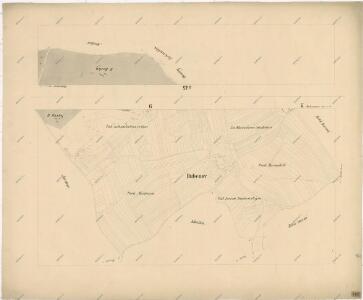
Hubenow - c2408-1-002 - Kaiserpflichtexemplar der Landkarten des stabilen Katasters
1 : 2880
Hubenow - c2408-1-006 - Kaiserpflichtexemplar der Landkarten des stabilen Katasters
1 : 2880
Hubenow - c2408-1-004 - Kaiserpflichtexemplar der Landkarten des stabilen Katasters
1 : 2880
Hubenow - c2408-1-001 - Kaiserpflichtexemplar der Landkarten des stabilen Katasters
1 : 2880
Lhotka - c3956-1-001 - Kaiserpflichtexemplar der Landkarten des stabilen Katasters
1 : 2880
Lhotka - c3956-1-002 - Kaiserpflichtexemplar der Landkarten des stabilen Katasters
1 : 2880
Mosting - c4852-1-004 - Kaiserpflichtexemplar der Landkarten des stabilen Katasters
1 : 2880
Mosting - c4852-1-002 - Kaiserpflichtexemplar der Landkarten des stabilen Katasters
1 : 2880
Mosting - c4852-1-001 - Kaiserpflichtexemplar der Landkarten des stabilen Katasters
1 : 2880
Mosting - c4852-1-003 - Kaiserpflichtexemplar der Landkarten des stabilen Katasters
1 : 2880
Porostní mapa polesí Hůrky
1 : 10000
III. vojenské mapování 4050/2
1 : 25000
[Kartenblatt]
1 : 25000 Dolní Bělá (Česko : oblast) Reichsamt für Landesaufnahme
Gradkartenblatt
1 : 25000 Manětín-oblast (Česko) Brzesina, Julius von


Mapa okresu Plzeň
Mapa plzeňského okresu. Vlevo dole vysvětlivky značek, vpravo dole grafická měřítka.
Zastupitelský okres Plzeňský
Rukopisná mapa zastupitelského okresu Plzeňského. Vyznačeny jednotlivé obce a hranice jejich katastrů. Zaznamenána síť sídel, vodních toků a komunikační. Znázorněny mlýny a rozptýlené jednotlivé stavby. Vlevo dole grafické měřítko.
Situační plán hájoven náležejících k panství Plasy
1 : 25000
III. vojenské mapování 4050
1 : 75000
Město Teplá
1 : 75000 Teplá (Cheb, Česko : oblast) Vojenský zeměpisný ústav
Město Teplá
1 : 75000 Teplá-oblast (Cheb, Česko) Vojenský zeměpisný ústav
Tepl und Tuschkau
1 : 75000 Město Touškov (Česko : oblast) Bloschitz, Rudolf K. u. k. Militärgeographisches Institut
Tepl und Tuschkau
1 : 75000 Město Touškov-oblast (Česko) K. u. k. Militärgeographisches Institut
[Umgebung von Kralowitz]
1 : 75000 Kralovice (Plzeň-sever, Česko : oblast) K. u. k. Militärgeographisches Institut