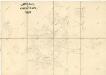
Maps of Dolní Hradiště

Katastrální mapa obce Dolní Hradiště
1 : 2880
Borek - c0374-1-001 - Kaiserpflichtexemplar der Landkarten des stabilen Katasters
1 : 2880
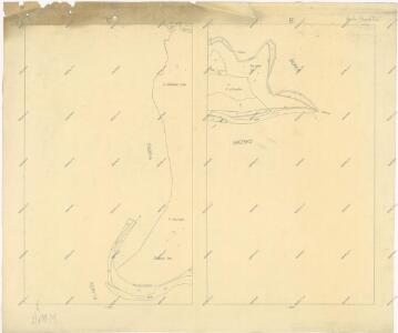
Unter Hradischt - c1292-1-003 - Kaiserpflichtexemplar der Landkarten des stabilen Katasters
1 : 2880
Unter Hradischt - c1292-1-002 - Kaiserpflichtexemplar der Landkarten des stabilen Katasters
1 : 2880
Unter Hradischt - c1292-1-001 - Kaiserpflichtexemplar der Landkarten des stabilen Katasters
1 : 2880
Katastrální mapa obce Borek WC-VI-VII-18 af df ag dg
1 : 2880
Katastrální mapa obce Břízsko
1 : 2880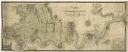
Porostní mapa čtyř hlavních částí polesí Čečín
1 : 2918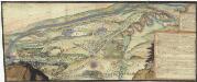
[Plasy]
Plasy-oblast (Česko)
III. vojenské mapování 4051/1
1 : 25000
III. vojenské mapování 4051/1
1 : 25000
Gradkartenblatt
1 : 25000 Kralovice-oblast (Plzeň-sever, Česko) Bulla, Eduard
Generální mapa panství Plasy se statkem Krašov (bez Kaceřova a Horní Bělé)
1 : 11611
Generální mapa lesů velkostatku Plasy
1 : 13186
Situační plán hájoven náležejících k panství Plasy
1 : 25000
Kralovice
1 : 75000 Kralovice (Plzeň-sever, Česko : oblast) Vojenský zeměpisný ústav
Kralowitz und Břas
1 : 75000 Břasy (Česko : oblast) Schulenburg, J. K. u. k. Militärgeographisches Institut
Kralowitz und Břas
1 : 75000 Břasy-oblast (Česko) K. u. k. Militärgeographisches Institut
Mapa školního a politického okresu Rokycanského
1 : 75000 Rokycany-oblast (Česko) Voj. zeměpisný ústav
[Umgebung von Kralowitz]
1 : 75000 Kralovice (Plzeň-sever, Česko : oblast) K. u. k. Militärgeographisches Institut
Kralovice a okolí
1 : 75000 Kralovice (Plzeň-sever, Česko : oblast) Vojenský zeměpisný ústav
Kralovice
1 : 75000 Kralovice-oblast (Plzeň-sever, Česko) Vojenský zeměpisný ústav
Kralovice
1 : 75000 Kralovice (Plzeň-sever, Česko : oblast) Vojenský zeměpisný ústav
Katastrální mapa obce Kopidlo-Kočín
1 : 2880
III. vojenské mapování 4051
1 : 75000
Soubor map okresů Pražského kraje

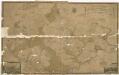
General Karte von der hochfürstlich von Metternich'schen Herrschaft Plass mit den vereinten Gütern Katzerow Kraschau u. Biela
1 : 150000 Horní Bělá-oblast (Česko) Wiehl, Anton Metternich, Klemens Wenzel Nepomuk Lothar von