Maps of Planá
Hospodářská mapa revíru Kočov
1 : 4343
Porostní mapa revíru Vysoké Sedliště
1 : 5760
Hospodářská mapa revíru Pavlovice
1 : 2880
Katastrální mapa obce Pavlovice
1 : 2880
Katastrální mapa obce Pavlovice ZSL-XIII-19 dh, ch
1 : 2880
Katastrální mapa obce Pavlovice
1 : 2880
Hospodářská mapa revíru Kočov
1 : 4343
Hospodářská mapa revíru Kočov
1 : 4377
Katastrální mapa obce Pavlovice ZSL-XIV-19 ah, ai
1 : 2880
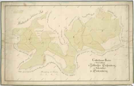
Hohenzetlisch - c8961-1-002 - Kaiserpflichtexemplar der Landkarten des stabilen Katasters
1 : 2880
Hohenzetlisch - c8961-1-004 - Kaiserpflichtexemplar der Landkarten des stabilen Katasters
1 : 2880
Hohenzetlisch - c8961-1-001 - Kaiserpflichtexemplar der Landkarten des stabilen Katasters
1 : 2880
Hohenzetlisch - c8961-1-003 - Kaiserpflichtexemplar der Landkarten des stabilen Katasters
1 : 2880
Porostní mapa revíru Pavlovice
1 : 5760
Hospodářská mapa revíru Pavlovice
1 : 2689
Pawlowitz (Pawlowice) - c5668-1-002 - Kaiserpflichtexemplar der Landkarten des stabilen Katasters
1 : 2880
Pawlowitz (Pawlowice) - c5668-1-003 - Kaiserpflichtexemplar der Landkarten des stabilen Katasters
1 : 2880
Pawlowitz (Pawlowice) - c5668-1-001 - Kaiserpflichtexemplar der Landkarten des stabilen Katasters
1 : 2880
Pawlowitz (Pawlowice) - c5668-1-004 - Kaiserpflichtexemplar der Landkarten des stabilen Katasters
1 : 2880
Truss - c8271-1-001 - Kaiserpflichtexemplar der Landkarten des stabilen Katasters
1 : 2880
Katastrální mapa obce Pavlovice ZSL-XIII-19 di
1 : 2880
Katastrální mapa obce Pavlovice
1 : 2880
Katastrální mapa obce Pavlovice
1 : 2880
Schliew - c9283-1-002 - Kaiserpflichtexemplar der Landkarten des stabilen Katasters
1 : 2880
Schliew - c9283-1-001 - Kaiserpflichtexemplar der Landkarten des stabilen Katasters
1 : 2880
Schliew - c9283-1-003 - Kaiserpflichtexemplar der Landkarten des stabilen Katasters
1 : 2880
[Kartenblatt]
1 : 25000 Planá (Tachov, Česko : oblast) Reichsamt für Landesaufnahme
III. vojenské mapování 4049/4
1 : 25000