Maps of Bor
Katastrální mapa obce Lhota
1 : 2880
Ellhotten - c3924-1-001 - Kaiserpflichtexemplar der Landkarten des stabilen Katasters
1 : 2880
Ellhotten - c3924-1-003 - Kaiserpflichtexemplar der Landkarten des stabilen Katasters
1 : 2880
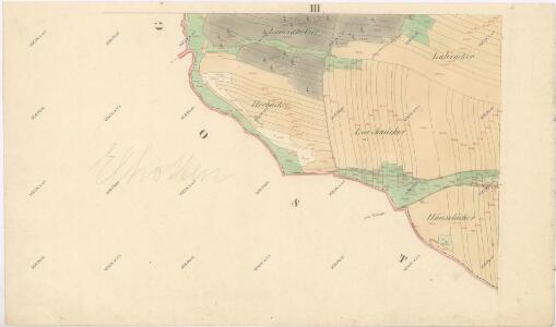
Ellhotten - c3924-1-002 - Kaiserpflichtexemplar der Landkarten des stabilen Katasters
1 : 2880
Ostrau - c5565-1-002 - Kaiserpflichtexemplar der Landkarten des stabilen Katasters
1 : 2880
Ostrau - c5565-1-004 - Kaiserpflichtexemplar der Landkarten des stabilen Katasters
1 : 2880
Ostrau - c5565-1-001 - Kaiserpflichtexemplar der Landkarten des stabilen Katasters
1 : 2880
Ostrau - c5565-1-003 - Kaiserpflichtexemplar der Landkarten des stabilen Katasters
1 : 2880
Hospodářská mapa revíru Kočov
1 : 11520
III. vojenské mapování 4049/4
1 : 25000

Gradkartenblatt
1 : 25000 Tachov-oblast (Česko) Bulla, Eduard
Hospodářská mapa revíru Kočov
1 : 4350

Uibersichtskarte der Herrschaft Tachau
Tachov-oblast (Česko) Waraus, E. André Verlag des böhm. Forstvereins
Hayder Vicariat
Bor-oblast (Tachov, Česko)
Stříbro a okolí
1 : 75000 Stříbro (Česko : oblast) Vojenský zeměpisný ústav
Mariánské Lázně
1 : 75000 Chodová Planá (Česko : oblast) Vojenský zeměpisný ústav
Mariánské Lázně
1 : 75000 Mariánské Lázně (Česko : oblast) Vojenský zeměpisný ústav
Mariánské Lázně
1 : 75000 Mariánské Lázně-oblast (Česko) Vojenský zeměpisný ústav
III. vojenské mapování 4049
1 : 75000
Politický okres Tachov
1 : 75000 Tachov (Česko : okres : 1960-) Vojenský zeměpisný ústav
Politický okres Tachov

Podrobná mapa Království českého
1 : 100000 Planá (Tachov, Česko : oblast) Srp, Jan Jaroslav Bursík
Böhmerwald-Verbindungsbahn
1 : 75000 Domažlice-Planá u Mariánských Lázní (Česko : železniční trať) Technisches Bureau Ing. Max Picha
Vilímkovy místopisné mapy zemí Koruny české
1 : 100000 Chodová Planá (Česko : oblast) Srp, Jan Jos. R. Vilímek
Tepl und Tuschkau.
from Spezialkarte der osterreichisch-ungarischen Monarchie.
Marienbad und Tachau.
from Spezialkarte der osterreichisch-ungarischen Monarchie.
[Okolí Plzně - západ]
Plzeň-oblast (Česko) Krejčí, Jan Schwarzenberg, Bedřich