Maps of Česká Kubice
Katastrální mapa obce Jindřichova Hora s obcí Černá Řeka
1 : 2880
Heinrichsberg - c0873-2-003 - Kaiserpflichtexemplar der Landkarten des stabilen Katasters
1 : 2880
Heinrichsberg - c0873-2-002 - Kaiserpflichtexemplar der Landkarten des stabilen Katasters
1 : 2880
Heinrichsberg - c0873-2-004 - Kaiserpflichtexemplar der Landkarten des stabilen Katasters
1 : 2880
Heinrichsberg - c0873-2-001 - Kaiserpflichtexemplar der Landkarten des stabilen Katasters
1 : 2880
Heinrichsberg - c0873-2-005 - Kaiserpflichtexemplar der Landkarten des stabilen Katasters
1 : 2880
Porotstní mapa revíru Černá Řeka
1 : 5747
Přehledná porostní mapa polesí Černá Řeka
1 : 11520
Porotstní mapa revíru Černá Řeka
1 : 5760
Katastrální mapa obce Chodov
1 : 2880
Plán silnice
1 : 25000
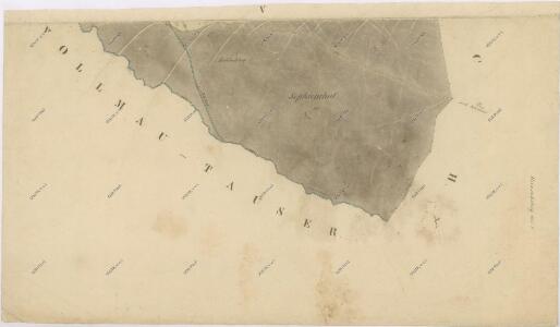
Vollmau Unter - c1279-1-006 - Kaiserpflichtexemplar der Landkarten des stabilen Katasters
1 : 2880
Vollmau Unter - c1279-1-016 - Kaiserpflichtexemplar der Landkarten des stabilen Katasters
1 : 2880
Vollmau Unter - c1279-1-007 - Kaiserpflichtexemplar der Landkarten des stabilen Katasters
1 : 2880
Vollmau Unter - c1279-1-001 - Kaiserpflichtexemplar der Landkarten des stabilen Katasters
1 : 2880
Vollmau Unter - c1279-1-008 - Kaiserpflichtexemplar der Landkarten des stabilen Katasters
1 : 2880
Vollmau Unter - c1279-1-011 - Kaiserpflichtexemplar der Landkarten des stabilen Katasters
1 : 2880
Vollmau Unter - c1279-1-012 - Kaiserpflichtexemplar der Landkarten des stabilen Katasters
1 : 2880
Vollmau Unter - c1279-1-010 - Kaiserpflichtexemplar der Landkarten des stabilen Katasters
1 : 2880
Vollmau Unter - c1279-1-019 - Kaiserpflichtexemplar der Landkarten des stabilen Katasters
1 : 2880
Vollmau Unter - c1279-1-017 - Kaiserpflichtexemplar der Landkarten des stabilen Katasters
1 : 2880
Vollmau Unter - c1279-1-013 - Kaiserpflichtexemplar der Landkarten des stabilen Katasters
1 : 2880
Vollmau Unter - c1279-1-015 - Kaiserpflichtexemplar der Landkarten des stabilen Katasters
1 : 2880
Vollmau Unter - c1279-1-003 - Kaiserpflichtexemplar der Landkarten des stabilen Katasters
1 : 2880
Vollmau Unter - c1279-1-009 - Kaiserpflichtexemplar der Landkarten des stabilen Katasters
1 : 2880
Vollmau Unter - c1279-1-014 - Kaiserpflichtexemplar der Landkarten des stabilen Katasters
1 : 2880
Vollmau Unter - c1279-1-020 - Kaiserpflichtexemplar der Landkarten des stabilen Katasters
1 : 2880
Vollmau Unter - c1279-1-005 - Kaiserpflichtexemplar der Landkarten des stabilen Katasters
1 : 2880
Vollmau Unter - c1279-1-004 - Kaiserpflichtexemplar der Landkarten des stabilen Katasters
1 : 2880
Vollmau Unter - c1279-1-002 - Kaiserpflichtexemplar der Landkarten des stabilen Katasters
1 : 2880