Maps of Chodov u Domažlic

Porostní mapa revíru Rudolfův les
1 : 5760
Katastrální mapa obce Chodov
1 : 2880
Katastrální mapa obce Trhanov
1 : 2880
Hospodářská mapa revíru Pec
1 : 5760
Porostní mapa revíru Pec
1 : 11520
Chodenschloss - c7957-1-014 - Kaiserpflichtexemplar der Landkarten des stabilen Katasters
1 : 2880
Chodenschloss - c7957-1-011 - Kaiserpflichtexemplar der Landkarten des stabilen Katasters
1 : 2880
Chodenschloss - c7957-1-001 - Kaiserpflichtexemplar der Landkarten des stabilen Katasters
1 : 2880
Chodenschloss - c7957-1-003 - Kaiserpflichtexemplar der Landkarten des stabilen Katasters
1 : 2880
Chodenschloss - c7957-1-013 - Kaiserpflichtexemplar der Landkarten des stabilen Katasters
1 : 2880
Chodenschloss - c7957-1-005 - Kaiserpflichtexemplar der Landkarten des stabilen Katasters
1 : 2880
Chodenschloss - c7957-1-009 - Kaiserpflichtexemplar der Landkarten des stabilen Katasters
1 : 2880
Chodenschloss - c7957-1-010 - Kaiserpflichtexemplar der Landkarten des stabilen Katasters
1 : 2880
Chodenschloss - c7957-1-012 - Kaiserpflichtexemplar der Landkarten des stabilen Katasters
1 : 2880
Chodenschloss - c7957-1-006 - Kaiserpflichtexemplar der Landkarten des stabilen Katasters
1 : 2880
Chodenschloss - c7957-1-004 - Kaiserpflichtexemplar der Landkarten des stabilen Katasters
1 : 2880
Chodenschloss - c7957-1-002 - Kaiserpflichtexemplar der Landkarten des stabilen Katasters
1 : 2880
Chodenschloss - c7957-1-008 - Kaiserpflichtexemplar der Landkarten des stabilen Katasters
1 : 2880
Chodenschloss - c7957-1-007 - Kaiserpflichtexemplar der Landkarten des stabilen Katasters
1 : 2880
Hospodářská mapa revíru Pec
1 : 5790
Mapy lesních porostů velkostatku Kout - revír Pec
1 : 11670
Hospodářská mapa revíru Pec
1 : 6069
Porostní mapa revíru Pec
1 : 11250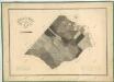
Hospodářská mapa revíru Pec
1 : 5760
Hospodářska mapa revíru Capartice
1 : 6680
Přehledná porostní mapa polesí Černá Řeka
1 : 11520
Hospodářska mapa revíru Capartice a Černá Řeka
1 : 12643
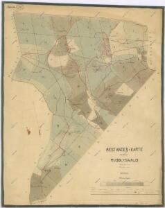
Hospodářská mapa revíru I. Rudolfův les a revíru II. Capartice
1 : 5760
Katastrální mapa obce Klenčí
1 : 2880