Maps of Všeruby

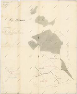
Hospodářská mapa revíru Chalupy
1 : 6851
Meumark - c8903-1-002 - Kaiserpflichtexemplar der Landkarten des stabilen Katasters
1 : 2880
Meumark - c8903-1-001 - Kaiserpflichtexemplar der Landkarten des stabilen Katasters
1 : 2880
Meumark - c8903-1-003 - Kaiserpflichtexemplar der Landkarten des stabilen Katasters
1 : 2880
Meumark - c8903-1-007 - Kaiserpflichtexemplar der Landkarten des stabilen Katasters
1 : 2880
Meumark - c8903-1-004 - Kaiserpflichtexemplar der Landkarten des stabilen Katasters
1 : 2880
Meumark - c8903-1-005 - Kaiserpflichtexemplar der Landkarten des stabilen Katasters
1 : 2880
Meumark - c8903-1-006 - Kaiserpflichtexemplar der Landkarten des stabilen Katasters
1 : 2880
Mapa alejí dvora Všeruby
1 : 5760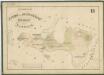
Přehledná mapa revíru a vrchnostenských pozemků dvora Všeruby
1 : 5835
Katastrální mapa obce Všeruby
1 : 2880
Hospodářská mapa revíru Všeruby
1 : 4930
Hospodářská mapa revíru Všeruby
1 : 5760
Mapy lesních porostů velkostatku Kout - revír Všeruby
1 : 5835
Katastrální mapa obce Myslív
1 : 2880
Donau - c1755-1-007 - Kaiserpflichtexemplar der Landkarten des stabilen Katasters
1 : 2880
Donau - c1755-1-002 - Kaiserpflichtexemplar der Landkarten des stabilen Katasters
1 : 2880
Donau - c1755-1-005 - Kaiserpflichtexemplar der Landkarten des stabilen Katasters
1 : 2880
Donau - c1755-1-003 - Kaiserpflichtexemplar der Landkarten des stabilen Katasters
1 : 2880
Donau - c1755-1-004 - Kaiserpflichtexemplar der Landkarten des stabilen Katasters
1 : 2880
Donau - c1755-1-001 - Kaiserpflichtexemplar der Landkarten des stabilen Katasters
1 : 2880
Donau - c1755-1-008 - Kaiserpflichtexemplar der Landkarten des stabilen Katasters
1 : 2880
Donau - c1755-1-006 - Kaiserpflichtexemplar der Landkarten des stabilen Katasters
1 : 2880
Mapa politického okresu Domažlického

III. vojenské mapování 4250/1, 4250/3
1 : 25000
III. vojenské mapování 4250/1, 4250/3
1 : 25000
Gradkartenblatt
1 : 25000 Všeruby-oblast (Domažlice, Česko) Bulla, Eduard
[Kartenblatt]
1 : 25000 Furth im Wald (Německo) Reichsamt für Landesaufnahme
III. vojenské mapování 4250/1, 4250/3
1 : 25000