Maps of Česká Kubice
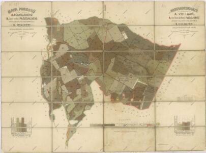
Porostní mapa revírů Folmava a Pasečnice a revíru Pec
1 : 11520
Katastrální mapa obce Trhanov
1 : 2880
Porostní mapa revírů Folmava a Pasečnice a revíru Pec
1 : 11520
Vollmau Unter - c1279-1-006 - Kaiserpflichtexemplar der Landkarten des stabilen Katasters
1 : 2880
Vollmau Unter - c1279-1-016 - Kaiserpflichtexemplar der Landkarten des stabilen Katasters
1 : 2880
Vollmau Unter - c1279-1-007 - Kaiserpflichtexemplar der Landkarten des stabilen Katasters
1 : 2880
Vollmau Unter - c1279-1-001 - Kaiserpflichtexemplar der Landkarten des stabilen Katasters
1 : 2880
Vollmau Unter - c1279-1-008 - Kaiserpflichtexemplar der Landkarten des stabilen Katasters
1 : 2880
Vollmau Unter - c1279-1-011 - Kaiserpflichtexemplar der Landkarten des stabilen Katasters
1 : 2880
Vollmau Unter - c1279-1-012 - Kaiserpflichtexemplar der Landkarten des stabilen Katasters
1 : 2880
Vollmau Unter - c1279-1-010 - Kaiserpflichtexemplar der Landkarten des stabilen Katasters
1 : 2880
Vollmau Unter - c1279-1-019 - Kaiserpflichtexemplar der Landkarten des stabilen Katasters
1 : 2880
Vollmau Unter - c1279-1-017 - Kaiserpflichtexemplar der Landkarten des stabilen Katasters
1 : 2880
Vollmau Unter - c1279-1-013 - Kaiserpflichtexemplar der Landkarten des stabilen Katasters
1 : 2880
Vollmau Unter - c1279-1-015 - Kaiserpflichtexemplar der Landkarten des stabilen Katasters
1 : 2880
Vollmau Unter - c1279-1-003 - Kaiserpflichtexemplar der Landkarten des stabilen Katasters
1 : 2880
Vollmau Unter - c1279-1-009 - Kaiserpflichtexemplar der Landkarten des stabilen Katasters
1 : 2880
Vollmau Unter - c1279-1-014 - Kaiserpflichtexemplar der Landkarten des stabilen Katasters
1 : 2880
Vollmau Unter - c1279-1-020 - Kaiserpflichtexemplar der Landkarten des stabilen Katasters
1 : 2880
Vollmau Unter - c1279-1-005 - Kaiserpflichtexemplar der Landkarten des stabilen Katasters
1 : 2880
Vollmau Unter - c1279-1-004 - Kaiserpflichtexemplar der Landkarten des stabilen Katasters
1 : 2880
Vollmau Unter - c1279-1-002 - Kaiserpflichtexemplar der Landkarten des stabilen Katasters
1 : 2880
Vollmau Unter - c1279-1-018 - Kaiserpflichtexemplar der Landkarten des stabilen Katasters
1 : 2880
Porostní mapa revíru Folmava
1 : 11520
Plán silnice
1 : 25000
Katastrální mapa obce Chodov
1 : 2880
Mapa porostů revírů
1 : 11520 Folmava (Česká Kubice, Česko) Brož, Jaroslav Krejčí, Jan
Hospodářská mapa revíru Pec
1 : 5760
Chodenschloss - c7957-1-014 - Kaiserpflichtexemplar der Landkarten des stabilen Katasters
1 : 2880
Chodenschloss - c7957-1-011 - Kaiserpflichtexemplar der Landkarten des stabilen Katasters
1 : 2880
Chodenschloss - c7957-1-001 - Kaiserpflichtexemplar der Landkarten des stabilen Katasters
1 : 2880
Chodenschloss - c7957-1-003 - Kaiserpflichtexemplar der Landkarten des stabilen Katasters
1 : 2880
Chodenschloss - c7957-1-013 - Kaiserpflichtexemplar der Landkarten des stabilen Katasters
1 : 2880
Chodenschloss - c7957-1-005 - Kaiserpflichtexemplar der Landkarten des stabilen Katasters
1 : 2880
Chodenschloss - c7957-1-009 - Kaiserpflichtexemplar der Landkarten des stabilen Katasters
1 : 2880
Chodenschloss - c7957-1-010 - Kaiserpflichtexemplar der Landkarten des stabilen Katasters
1 : 2880
Chodenschloss - c7957-1-012 - Kaiserpflichtexemplar der Landkarten des stabilen Katasters
1 : 2880
Chodenschloss - c7957-1-006 - Kaiserpflichtexemplar der Landkarten des stabilen Katasters
1 : 2880
Chodenschloss - c7957-1-004 - Kaiserpflichtexemplar der Landkarten des stabilen Katasters
1 : 2880
Chodenschloss - c7957-1-002 - Kaiserpflichtexemplar der Landkarten des stabilen Katasters
1 : 2880
Chodenschloss - c7957-1-008 - Kaiserpflichtexemplar der Landkarten des stabilen Katasters
1 : 2880