Maps of Waldmünchen

Porotstní mapa revíru Černá Řeka
1 : 5747
Porotstní mapa revíru Černá Řeka
1 : 5760
Přehledná porostní mapa polesí Černá Řeka
1 : 11520
Heinrichsberg - c0873-2-003 - Kaiserpflichtexemplar der Landkarten des stabilen Katasters
1 : 2880
Heinrichsberg - c0873-2-002 - Kaiserpflichtexemplar der Landkarten des stabilen Katasters
1 : 2880
Heinrichsberg - c0873-2-004 - Kaiserpflichtexemplar der Landkarten des stabilen Katasters
1 : 2880
Heinrichsberg - c0873-2-001 - Kaiserpflichtexemplar der Landkarten des stabilen Katasters
1 : 2880
Heinrichsberg - c0873-2-005 - Kaiserpflichtexemplar der Landkarten des stabilen Katasters
1 : 2880
Katastrální mapa obce Lísková
1 : 2880
Katastrální mapa obce Jindřichova Hora s obcí Černá Řeka
1 : 2880
Katastrální mapa obce Nemanice spolu s obcemi Nová Huť a Stará Huť
1 : 2880
Katastrální mapa obce Nemanice spolu s obcemi Nová Huť a Stará Huť
1 : 2880
Katastrální mapa obce Nemanice spolu s obcemi Nová Huť a Stará Huť
1 : 2880
Katastrální mapa obce Jindřichova Hora s obcí Černá Řeka
1 : 2880
Přehledná mapa revíru Černá Řeka
1 : 12643
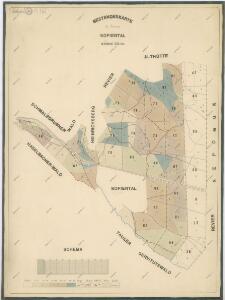
Hospodářské mapa lesního oddělení Novosedlské Hutě
1 : 6107
Hospodářska mapa revíru Capartice
1 : 6680
Hospodářská mapa revíru I. Rudolfův les a revíru II. Capartice
1 : 5760
Haselbach - c4128-3-003 - Kaiserpflichtexemplar der Landkarten des stabilen Katasters
1 : 2880
Haselbach - c4128-3-004 - Kaiserpflichtexemplar der Landkarten des stabilen Katasters
1 : 2880
Haselbach - c4128-3-002 - Kaiserpflichtexemplar der Landkarten des stabilen Katasters
1 : 2880
Haselbach - c4128-3-001 - Kaiserpflichtexemplar der Landkarten des stabilen Katasters
1 : 2880
Haselbach - c4128-3-005 - Kaiserpflichtexemplar der Landkarten des stabilen Katasters
1 : 2880
Haselbach - c4128-3-006 - Kaiserpflichtexemplar der Landkarten des stabilen Katasters
1 : 2880
Porostní mapa revíru Capartice
1 : 5760
Katastrální mapa obce Postřekov
1 : 2880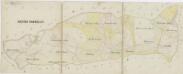
Hospodářská mapa revíru Postřekov
1 : 5338
Přehledná porostní mapa lesů velkostatku Trhanov
1 : 11520
Přehledná lesní mapa velkostatku Trhanov
1 : 11520