Maps of Babylon
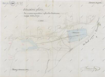
Plán znovunapuštění rybníka Hadrovce u obce Újezd
1 : 2880
Babilon - c0053-1-006 - Kaiserpflichtexemplar der Landkarten des stabilen Katasters
1 : 2880
Babilon - c0053-1-004 - Kaiserpflichtexemplar der Landkarten des stabilen Katasters
1 : 2880
Babilon - c0053-1-008 - Kaiserpflichtexemplar der Landkarten des stabilen Katasters
1 : 2880
Babilon - c0053-1-003 - Kaiserpflichtexemplar der Landkarten des stabilen Katasters
1 : 2880
Babilon - c0053-1-005 - Kaiserpflichtexemplar der Landkarten des stabilen Katasters
1 : 2880
Babilon - c0053-1-007 - Kaiserpflichtexemplar der Landkarten des stabilen Katasters
1 : 2880
Babilon - c0053-1-002 - Kaiserpflichtexemplar der Landkarten des stabilen Katasters
1 : 2880
Babilon - c0053-1-001 - Kaiserpflichtexemplar der Landkarten des stabilen Katasters
1 : 2880
Babilon - c0053-1-009 - Kaiserpflichtexemplar der Landkarten des stabilen Katasters
1 : 2880
Augezdl (Augezdo) - c8202-1-004 - Kaiserpflichtexemplar der Landkarten des stabilen Katasters
1 : 2880
Augezdl (Augezdo) - c8202-1-001 - Kaiserpflichtexemplar der Landkarten des stabilen Katasters
1 : 2880
Augezdl (Augezdo) - c8202-1-003 - Kaiserpflichtexemplar der Landkarten des stabilen Katasters
1 : 2880
Augezdl (Augezdo) - c8202-1-006 - Kaiserpflichtexemplar der Landkarten des stabilen Katasters
1 : 2880
Augezdl (Augezdo) - c8202-1-002 - Kaiserpflichtexemplar der Landkarten des stabilen Katasters
1 : 2880
Augezdl (Augezdo) - c8202-1-005 - Kaiserpflichtexemplar der Landkarten des stabilen Katasters
1 : 2880
Alt und Neu Paschnitz(St.a Now.Pašešnice - c5641-1-002 - Kaiserpflichtexemplar der Landkarten des stabilen Katasters
1 : 2880
Alt und Neu Paschnitz(St.a Now.Pašešnice - c5641-1-004 - Kaiserpflichtexemplar der Landkarten des stabilen Katasters
1 : 2880
Alt und Neu Paschnitz(St.a Now.Pašešnice - c5641-1-005 - Kaiserpflichtexemplar der Landkarten des stabilen Katasters
1 : 2880
Alt und Neu Paschnitz(St.a Now.Pašešnice - c5641-1-007 - Kaiserpflichtexemplar der Landkarten des stabilen Katasters
1 : 2880
Alt und Neu Paschnitz(St.a Now.Pašešnice - c5641-1-003 - Kaiserpflichtexemplar der Landkarten des stabilen Katasters
1 : 2880
Alt und Neu Paschnitz(St.a Now.Pašešnice - c5641-1-006 - Kaiserpflichtexemplar der Landkarten des stabilen Katasters
1 : 2880
Alt und Neu Paschnitz(St.a Now.Pašešnice - c5641-1-001 - Kaiserpflichtexemplar der Landkarten des stabilen Katasters
1 : 2880
Porostní mapa revírů Folmava a Pasečnice a revíru Pec
1 : 11520
Porostní mapa revírů Folmava a Pasečnice a revíru Pec
1 : 11520
Katastrální mapa obce Trhanov
1 : 2880

III. vojenské mapování 4250/1
1 : 25000
III. vojenské mapování 4250/1
1 : 25000