Maps of Vejen Municipality

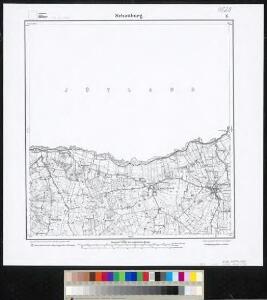
Meßtischblatt 15 : Schottburg, 1880
1 : 250000 Schottburg. - Aufn. 1878. - 1:25000. - [Berlin]: Reichsamt für Landesaufnahme, 1880. - 1 Kt.
PARS ORIENTALIS | PRÆFECTVRÆ | HADERSLEBEN | Vulgo dictæ Baringsijßel.
Matthias Vnd Clauss Petersen | G.S. gebr. | Husumenss. sculps. [Amsterdam : Joan Blaeu]
3. Lügumkloster, uit: Topographische Uebersichtskarte des Deutschen Reiches / herausgegeben v. d. Kartogr. Abt. d. Königl. Preuß. Landesaufnahme
1 : 200000 titelvariant: Topogr. Übersichtskarte des Deutschen Reiches; Annotatie: Titel boven bladen ook: Topogr. Übersichtskarte des Deutschen Reiches; Annotatie geografische gegevens: Op elk blad twee maatstokken: 10 Kilometer = 5,5 cm; 1 geogr. Meile = 3,6 cm; Legenda onder op elk blad Königlich Preußische Landesaufnahme. Kartographische Abtheilung [S.l : Königlich Preußische Landesaufnahme, Kartographische Abtheilung]
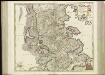
DVCATVS | SLESWICI | PARS BOREALIS.
Matthias und Nicolaus Pet. | Goldtschmide gebr. Hus. sculp. [Amsterdam : Joan Blaeu]
Ducatus Slesvicensis Pars Septentrionalis. [Karte], in: Novus atlas absolutissimus, Bd. 1, S. 158.
1 Karte aus Atlas Janssonius Offizin
Das Herzongthum Schleswig

Schleswig.
1 : 427000 Gotthard, A.
FIONIA | vulgo | FVNEN.
[Amsterdam : Joan Blaeu]
Ducatus Slesvicensis
1 : 312700 Šlesvicko Homann, Johann Baptist a Ioh. Baptista Homan[n]o
Fionia [Karte], in: Atlas, sive, Cosmographicae meditationes de fabrica mundi et fabricati figura, S. 144.
1 Karte aus Atlas Mercator, Gerhard
Fionia vulgo Funen [Karte], in: Novus Atlas, das ist, Weltbeschreibung, Bd. 1, S. 36.
1 Karte aus Atlas Blaeu, Joan Blaeu, Willem Janszoon
DUCATUS SLESVICENSIS juxta novißimam et accuratißimam Designationem
1 : 325000 Šlesvicko Seutter, Matthäus sumtibus Matth. Seutteri

Fiona vulgo Funen [Karte], in: Theatrum orbis terrarum, sive, Atlas novus, Bd. 1, S. 50.
1 Karte aus Atlas Blaeu, Joan Blaeu, Willem Janszoon
Ducatus Slesvicensis in omnes suas praefecturas circulos et provincias distinté divisus
1 : 310000 per F. de Wit 't Amsterdam : by F. de Wit, op den Dam, inde Witte Pascaert
Fionia vulgo Funen [Karte], in: Le théâtre du monde, ou, Nouvel atlas contenant les chartes et descriptions de tous les païs de la terre, Bd. 1, S. 52.
1 Karte aus Atlas Blaeu, Willem Janszoon und Blaeu, Joan Blaeu, Willem Janszoon
Jutland II.
1 : 480000 Berghaus, Heinrich; Flemming, Carl; Sohr, Karl
[66][66] Ducatus Slesvicensis ...., uit: Atlas sive Descriptio terrarum orbis
Annotatie: Gedigitaliseerde versie. Amsterdam. Heiloo : Picturae (vervaardiger), 2015. tiff-bestand. Gedigitaliseerd: 07-01-2015; Origineel: Universiteitsbibliotheek Vrije Universiteit (XL.05127.-) ; Netherlands; Titelpagina ontbreekt Wit, Frederik de Amsterdam : Frederick de Wit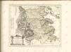

PARS AVSTRALIOR | IVTIÆ SEPTENTRIONALIS, | in qua DIOECESES | RIPENSIS | et | ARHVSIENSIS.
[Amsterdam : Joan Blaeu]
DVCATVS | SLESWICVM | sive | IVTIA AVSTRALIS.
Matthias undt Nicolaus Peters Goldts. gebr. | Hus. sculps. [Amsterdam : Joan Blaeu]
Nationalitäten- und Sprachenkarte des Herzogthums Schleswig
1 : 480000 Jutský poloostrov (Dánsko a Německo) Biernatzki, Hermann Berendsohn, Bernhard S. B.S. Berendsohn
Ducatus Sleswicensis, Nova Descriptio. [Karte], in: Novus atlas absolutissimus, Bd. 1, S. 155.
1 Karte aus Atlas Janssonius Offizin
Jutia Australis, in qua Dioeceses Ripensis et Arhusiensis. [Karte], in: Novus atlas absolutissimus, Bd. 1, S. 140.
1 Karte aus Atlas Janssonius Offizin
Schleswig, Jutland, Funen.
1 : 480000 Flemming, Carl
Sect. 1: Schleswig, uit: Geologische Karte des Deutschen Reichs in 27 Blaettern / [von] Richard Lepsius ; Red. von C. Vogel
1 : 500000 Annotatie: Blad 18 ontbreekt; Een aantal bladen op linnen; Een aantal bladen gereviseerd 1913-1914; Annotatie geografische gegevens: Met schaalstokken o.a. in kilometers; Legenda Carl Vogel 1828-1897 Gotha : Justus Perthes
Sprachgrenze in Schleswig
1 : 500000 Herzogtum Schleswig Sprachgrenze
General Karte der Herzogthümer Schleswig Holstein und Lauenburg
1 : 500000 Lübeck (Německo : oblast) Stolzenberg, Alfred Pauliny, J. J. J.J. Pauliny