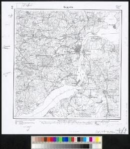
Maps of Kappeln-Land

Meßtischblatt 209 : Kappeln, 1891
1 : 250000 Kappeln. - Aufn. 1877, hrsg. 1879, einz. Nachtr. 1891. - 1:25000. - [Berlin]: Reichsamt für Landesaufnahme, 1891. - 1 Kt.
ACCVRATISSIMA | SLIÆ FLVMINIS | DESCRIPTIO.
Christian Lorensen | Rodtgiesser sculps. [Amsterdam : Joan Blaeu]
39. Kappeln. (Germany)
1 : 100000 Reichsamt fur Landesaufnahme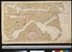
Afteekening van de Rivier van Sleeswijck waer bij dessefls incomen int grood wort vertoont geleegen in de Beldt
Germany Gerard van Keulen
Composite: 39. Kappeln. (Germany)
1 : 100000 Reichsamt fur Landesaufnahme
PRÆFECTVRÆ | GOTTORPIENSIS | pars Borealis.
Matthias und Clauss Petersen | Goldtschmide gebr. Hus. sculps. [Amsterdam : Joan Blaeu]
TERRITORIA | ANGLEN | ET | SCHWANSEN | Anno 1649
Matthias und Clauss Petersen Goldtschmide und gebr. | Hus. Cimb. sculps. [Amsterdam : Joan Blaeu]
10. Schleswig, uit: Topographische Uebersichtskarte des Deutschen Reiches / herausgegeben v. d. Kartogr. Abt. d. Königl. Preuß. Landesaufnahme
1 : 200000 titelvariant: Topogr. Übersichtskarte des Deutschen Reiches; Annotatie: Titel boven bladen ook: Topogr. Übersichtskarte des Deutschen Reiches; Annotatie geografische gegevens: Op elk blad twee maatstokken: 10 Kilometer = 5,5 cm; 1 geogr. Meile = 3,6 cm; Legenda onder op elk blad Königlich Preußische Landesaufnahme. Kartographische Abtheilung [S.l : Königlich Preußische Landesaufnahme, Kartographische Abtheilung]
Special-Karte von Süd-Schleswig
1 : 150000 Šlesvicko Petermann, August Justus Perthes
Special-Karte von Süd-Schleswig
1 : 150000 Šlesvicko Petermann, August Friedrich Ehrlich
Special-Karte von Süd-Schleswig
1 : 150000 Šlesvicko Petermann, August Justus Perthes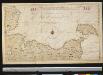
Het Zuijdelijkste gedeelte van de Beld, van de Riv. Sleeswijk tot t eijl. Femeren
Germany Gerard van Keulen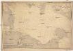
Ostsee
1 : 100000 Dánsko Reichs-Marine-Amt
Kiel 21, uit: Special-Karte von Mittel-Europa / nach amtlichen Quellen bearbeitet von W. Liebenow
1 : 300000 titelvariant: W. Liebenow's Mittel-Europa; Annotatie: Titel boven de bladen: W. Liebenow's Mittel-Europa Johannes Wilhelm Liebenow 1822-1897 Frankfurt a. M. : Ludwig Ravenstein
Kiel 21, uit: [W. Liebenow's Special-Karte von Mittel-Europa]
1 : 300000 titelvariant: W. Liebenow's Mittel-Europa; Annotatie: Titel boven de bladen: W. Liebenow's Mittel-Europa Johannes Wilhelm Liebenow 1822-1897 Hannover : Hermann Oppermann
Das oestliche Holstein

Szleswig
Deutschland Dänemark Regierungsbezirk Schleswig Grenze Wierzbicki, B.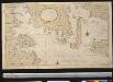
Een gedeelte van de Beldt Zee vertoonende desselfs Westelijkste zeekusten int grood bestek
Denmark Gerard van Keulen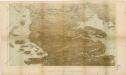
Das Herzongthum Schleswig

Schleswig.
1 : 427000 Gotthard, A.
Herzogthum Schleswig
Grosser Hand-Atlas über alle Theile der Erde in 170 Karten Meyer, J. Verlag des Bibliographischen Instituts
DVCATVS | SLESWICI | PARS MERIDIONALIS.
Matthias undt Nicolaus Peters Goldts. gebr. | Hus. sculps. [Amsterdam : Joan Blaeu]
Nova et Accurata descriptio totius Fioniae vulgo Funen. [Karte], in: Novus atlas absolutissimus, Bd. 1, S. 131.
1 Karte aus Atlas Janssonius Offizin
Ducatus Slesvicensis
1 : 312700 Šlesvicko Homann, Johann Baptist a Ioh. Baptista Homan[n]o
DUCATUS SLESVICENSIS juxta novißimam et accuratißimam Designationem
1 : 325000 Šlesvicko Seutter, Matthäus sumtibus Matth. Seutteri

Holsatiae descrip
1 Karte : Kupferdruck ; 32 x 23 cm Jorden; Ortelius s.n.
Ducatus Slesvicensis in omnes suas praefecturas circulos et provincias distinté divisus
1 : 310000 per F. de Wit 't Amsterdam : by F. de Wit, op den Dam, inde Witte Pascaert