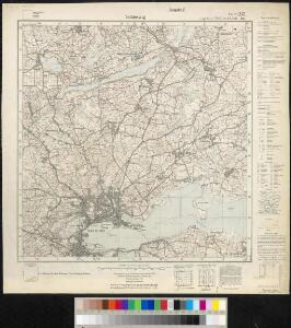
Maps of Nübel

Meßtischblatt 251, neue Nr. 1423 : Schleswig, 1937
1 : 250000 Schleswig. - Hrsg. 1879, bericht. 1926, einz. Nachtr. 1929, mehrfarb. Ausg. 1933. - 1:25000. - [Berlin]: Reichsamt für Landesaufnahme, 1937. - 1 Kt.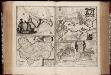
Newe Landtcarte von der Insull Helgelandt anno 1649 / author Johannes Mejer ; Helgel?dt in annis Christi 800, 1300 & 1649 / Matthias und Clauß Petersen ; Grundtriß der Stadt Sleßwieg anno 1649 ; Grundtriß von Dennewarcks wall und der alten Stadt Sleßwieg wij ess anno 1154 gewesen
titelvariant: Helgel?dt in annis Christi 800, 1300 & 1649; Grundtriß der Stadt Sleßwieg anno 1649; Grundtriß von Dennewarcks wall und der alten Stadt Sleßwieg wij ess anno 1154 gewesen; Annotatie: Origineel is Blad 83 in atlas factice Johannes Mejer 1606-1674; Matthias Petersen 1632- 1706; Clauß Petersen [S.l. : s.n.]
Plan des Schlachtfeldes von Schleswig
1 : 15000 [Schropp]
Plan des Schlachtfeldes von Schleswig
1 : 15000 [Schropp]
Composite: 38. Schleswig. (Germany)
1 : 100000 Reichsamt fur Landesaufnahme
38. Schleswig. (Germany)
1 : 100000 Reichsamt fur Landesaufnahme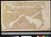
Afteekening van de Rivier van Sleeswijck waer bij dessefls incomen int grood wort vertoont geleegen in de Beldt
Germany Gerard van Keulen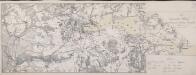
Die Dannewerks-Stellung
1 : 40000
PRÆFECTVRÆ | GOTTORPIENSIS | pars Borealis.
Matthias und Clauss Petersen | Goldtschmide gebr. Hus. sculps. [Amsterdam : Joan Blaeu]
TERRITORIA | ANGLEN | ET | SCHWANSEN | Anno 1649
Matthias und Clauss Petersen Goldtschmide und gebr. | Hus. Cimb. sculps. [Amsterdam : Joan Blaeu]
10. Schleswig, uit: Topographische Uebersichtskarte des Deutschen Reiches / herausgegeben v. d. Kartogr. Abt. d. Königl. Preuß. Landesaufnahme
1 : 200000 titelvariant: Topogr. Übersichtskarte des Deutschen Reiches; Annotatie: Titel boven bladen ook: Topogr. Übersichtskarte des Deutschen Reiches; Annotatie geografische gegevens: Op elk blad twee maatstokken: 10 Kilometer = 5,5 cm; 1 geogr. Meile = 3,6 cm; Legenda onder op elk blad Königlich Preußische Landesaufnahme. Kartographische Abtheilung [S.l : Königlich Preußische Landesaufnahme, Kartographische Abtheilung]
Special-Karte von Süd-Schleswig
1 : 150000 Šlesvicko Petermann, August Justus Perthes
Special-Karte von Süd-Schleswig
1 : 150000 Šlesvicko Petermann, August Friedrich Ehrlich
Special-Karte von Süd-Schleswig
1 : 150000 Šlesvicko Petermann, August Justus Perthes
Kiel 21, uit: Special-Karte von Mittel-Europa / nach amtlichen Quellen bearbeitet von W. Liebenow
1 : 300000 titelvariant: W. Liebenow's Mittel-Europa; Annotatie: Titel boven de bladen: W. Liebenow's Mittel-Europa Johannes Wilhelm Liebenow 1822-1897 Frankfurt a. M. : Ludwig Ravenstein
Kiel 21, uit: [W. Liebenow's Special-Karte von Mittel-Europa]
1 : 300000 titelvariant: W. Liebenow's Mittel-Europa; Annotatie: Titel boven de bladen: W. Liebenow's Mittel-Europa Johannes Wilhelm Liebenow 1822-1897 Hannover : Hermann Oppermann
Das oestliche Holstein

Szleswig
Deutschland Dänemark Regierungsbezirk Schleswig Grenze Wierzbicki, B.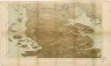
Das Herzongthum Schleswig

Schleswig.
1 : 427000 Gotthard, A.
Herzogthum Schleswig
Grosser Hand-Atlas über alle Theile der Erde in 170 Karten Meyer, J. Verlag des Bibliographischen Instituts
DVCATVS | SLESWICI | PARS MERIDIONALIS.
Matthias undt Nicolaus Peters Goldts. gebr. | Hus. sculps. [Amsterdam : Joan Blaeu]
Ducatus Slesvicensis
1 : 312700 Šlesvicko Homann, Johann Baptist a Ioh. Baptista Homan[n]o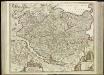
[45][45] Holsatiae tabula generalis ..., uit: Atlas sive Descriptio terrarum orbis
Annotatie: Gedigitaliseerde versie. Amsterdam. Heiloo : Picturae (vervaardiger), 2015. tiff-bestand. Gedigitaliseerd: 07-01-2015; Origineel: Universiteitsbibliotheek Vrije Universiteit (XL.05127.-) ; Netherlands; Titelpagina ontbreekt Wit, Frederik de Amsterdam : Frederick de Wit
DUCATUS SLESVICENSIS juxta novißimam et accuratißimam Designationem
1 : 325000 Šlesvicko Seutter, Matthäus sumtibus Matth. Seutteri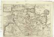
Dvcatvs Holsatiae
Holštýnsko Bouttats, Gaspar


Holsatiae descrip
1 Karte : Kupferdruck ; 32 x 23 cm Jorden; Ortelius s.n.