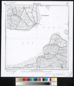
Maps of Simonsberg

Meßtischblatt 297 : Simonsberg, 1897
1 : 250000 Simonsberg. - Aufn. 1878, hrsg. 1880, einz. Nachtr. 1897. - 1:25000. - [Berlin]: Reichsamt für Landesaufnahme, 1897. - 1 Kt.
Composite: 56. Husum. (Germany)
1 : 100000 Reichsamt fur Landesaufnahme
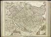
TERRITORIA | EIJDERSTEDE | Everschop | et | Uthholm.
Matthias und Nicolaus Pet. Goldtschmide gebr. | Husum. sculps. [Amsterdam : Joan Blaeu]
56. Husum. (Germany)
1 : 100000 Reichsamt fur Landesaufnahme
PRÆFECTURA | HVSVMENSIS | LVNDERBERGH NORDSTRAND | et NORDGOESHERDE.
Matthias Vnd Clauss Petersen | G.S. gebr. | Husumenss. sculps. [Amsterdam : Joan Blaeu]
22. Husum, uit: Topographische Uebersichtskarte des Deutschen Reiches / herausgegeben v. d. Kartogr. Abt. d. Königl. Preuß. Landesaufnahme
1 : 200000 titelvariant: Topogr. Übersichtskarte des Deutschen Reiches; Annotatie: Titel boven bladen ook: Topogr. Übersichtskarte des Deutschen Reiches; Annotatie geografische gegevens: Op elk blad twee maatstokken: 10 Kilometer = 5,5 cm; 1 geogr. Meile = 3,6 cm; Legenda onder op elk blad Königlich Preußische Landesaufnahme. Kartographische Abtheilung [S.l : Königlich Preußische Landesaufnahme, Kartographische Abtheilung]
DITHMARSIÆ | PARS SEPTENTRIONALIS [...]
author Iohannes Mejer Husum. | Regæ. Majis. Mathematicus Matthis Pet. v Clauß Peterss Goldtschmide unt gb. Hus. Cimbr. sculp. [Amsterdam : Joan Blaeu]
Tönning 20, uit: [W. Liebenow's Special-Karte von Mittel-Europa]
1 : 300000 titelvariant: W. Liebenow's Mittel-Europa; Annotatie: Titel boven de bladen: W. Liebenow's Mittel-Europa Johannes Wilhelm Liebenow 1822-1897 Hannover : Hermann Oppermann
Tönning 20, uit: Special-Karte von Mittel-Europa / nach amtlichen Quellen bearbeitet von W. Liebenow
1 : 300000 titelvariant: W. Liebenow's Mittel-Europa; Annotatie: Titel boven de bladen: W. Liebenow's Mittel-Europa Johannes Wilhelm Liebenow 1822-1897 Frankfurt a. M. : Ludwig Ravenstein
Dithmarsia Rendesburgum Kiel et Bordesholm in Occidentali parte Holsatiae
1 : 210000 Mollova mapová sbírka Schenk, Pieter Schenk, Peter I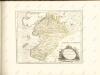

Dithmarsia, Rendesburgum, Kiel et Bordesholm, in Occidentali parte Holsatiae. [Karte], in: Novus atlas absolutissimus, Bd. 1, S. 146.
1 Karte aus Atlas Janssonius Offizin
Szleswig
Deutschland Dänemark Regierungsbezirk Schleswig Grenze Wierzbicki, B.
[left] FRISIA BOREALIS | IN DVCATV SLESWICENSI | sive FRISIA CIMBRICA | Anno 1651. [right] FRISIA BOREALIS | IN DVCATV SLESWICENSI | Anno 1240. | Frisia Cimbrica Antiqua.
Matthias & Nicolao Peters | Goldtschmide gbr. Husum. sculps. [Amsterdam : Joan Blaeu]
Das Herzongthum Schleswig

Schleswig.
1 : 427000 Gotthard, A.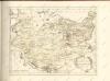

Herzogthum Schleswig
Grosser Hand-Atlas über alle Theile der Erde in 170 Karten Meyer, J. Verlag des Bibliographischen Instituts
Holstein, Lauenburg, Hamburg, Lubeck.
1 : 435000 Flemming, Carl
DVCATVS | SLESWICI | PARS MERIDIONALIS.
Matthias undt Nicolaus Peters Goldts. gebr. | Hus. sculps. [Amsterdam : Joan Blaeu]
Tabvla Generalis Holsatiae complectens Holsatiae Dithmarsiae Stormariae et Vagriae Dvcatvs
1 : 310000 Mollova mapová sbírka Homann, Johann Baptist Homann, Johann Baptista
Tabvla Generalis Holsatiae complectens Holsatiae Dithmarsiae Stormariae et Vagriae Dvcatvs
1 : 310000 Mollova mapová sbírka Homann, Johann Baptist Homann, Johann Baptista

Holsatiae Dithmarsiae Stormariae et Vagriae Dvcatvs
1 : 480000 Mollova mapová sbírka Weigel, Christoph Kauffer, Michael Weigel, Christoph I.
Herzogthum Holstein im Nieder Sächsischen Creisse mit seinen abgetheilten Provintzien
Mollova mapová sbírka Weigel, Christoph Weigel, Christoph I.
Ducatus Slesvicensis
1 : 312700 Šlesvicko Homann, Johann Baptist a Ioh. Baptista Homan[n]o
Holsatia ducatus
1 Karte : Kupferdruck ; 33 x 46 cm Mercator; Hondius Henricus Hondius
Tabvla generalis Holsatiae complectens Holsatiae Dithmarsiae Stormariae et Vargiae dvcatvs
1 : 316000 Holštýnsko Homann, Johann Baptist a Ioh. Bapt. Homanno
Tabula Generalis Holsatiae
1 : 310000 Mollova mapová sbírka Danckerts, Theodorus Danckerts, Theodor