Maps of Cuxhaven

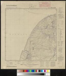
Meßtischblatt 2117 : Altenwalde, 1941
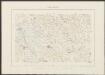
1 : 250000 Altenwalde. - Aufn. 1878, hrsg. 1880, letzte Nachtr. 1926. - 1:25000. - [Berlin]: Reichsamt für Landesaufnahme, 1941. - 1 Kt.
Composite: 110. Cuxhaven. (Germany)
1 : 100000 Reichsamt fur Landesaufnahme
110. Cuxhaven. (Germany)
1 : 100000 Reichsamt fur Landesaufnahme
Nordsee
1 : 50000 Cuxhaven (Německo) Reichs-Marine-Amt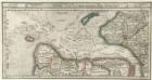
Gluckstatt mitt dero Gegend Westwerth und von daar die Elbe vollend hinnab zufahren bis in die Westsee, sampt dem Hamburgischen Ampt Ritzbuttel.
1 : 310000 Mollova mapová sbírka Bodenehr, Gabriel Bodenehr, Gabriel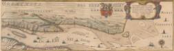
Celeberrimi Fluvii Albis nova delineatio [Karte, Teil 2], in: Novus Atlas, das ist, Weltbeschreibung, Bd. 1, S. 117.
1 Karte aus Atlas Blaeu, Joan Blaeu, Willem Janszoon
39. Bremerhaven, uit: Topographische Uebersichtskarte des Deutschen Reiches / herausgegeben v. d. Kartogr. Abt. d. Königl. Preuß. Landesaufnahme
1 : 200000 titelvariant: Topogr. Übersichtskarte des Deutschen Reiches; Annotatie: Titel boven bladen ook: Topogr. Übersichtskarte des Deutschen Reiches; Annotatie geografische gegevens: Op elk blad twee maatstokken: 10 Kilometer = 5,5 cm; 1 geogr. Meile = 3,6 cm; Legenda onder op elk blad Königlich Preußische Landesaufnahme. Kartographische Abtheilung [S.l : Königlich Preußische Landesaufnahme, Kartographische Abtheilung]
Celeberrimi Fluvii Albis nova delineatio [Karte, Teil 2], in: Le théâtre du monde, ou, Nouvel atlas contenant les chartes et descriptions de tous les païs de la terre, Bd. 1, S. 148.
1 Karte aus Atlas Blaeu, Willem Janszoon und Blaeu, Joan Blaeu, Willem Janszoon
Celeberrimi Fluvii Albis nova delineatio [Karte, Teil 2], in: Theatrum orbis terrarum, sive, Atlas novus, Bd. 1, S. 182.
1 Karte aus Atlas Blaeu, Joan Blaeu, Willem Janszoon
Nobilis Fluvius Albis maximâ curâ, ex variis, famosisque Autoribus collectus, et in lucem editus. [Karte, Teil 2], in: Gerardi Mercatoris et I. Hondii Newer Atlas, oder, Grosses Weltbuch, Bd. 1, S. 277.
1 Karte aus Atlas Mercator, Gerhard und Hondius, Jodocus Jansson, Jan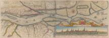
Nobilis Fluvius Albis maximâ curâ, ex variis famosisque Autoribus collectus, et in lucem editus. [Karte, Teil 2], in: Novus atlas absolutissimus, Bd. 2, S. 33.
1 Karte aus Atlas Janssonius Offizin
Nobilis Saxoniae Fl. Visurgis, cum Terris adjacentib.
1 : 110000 Mollova mapová sbírka Loon, Jan van Schenk, Peter I
Nobilis Saxoniae Fl. Visurgis, cum Terris adjacentib.
1 : 110000 Mollova mapová sbírka Loon, Jan van Janssonius, Johannes I
Dvcatvs Bremae et Princ. Verdae
1 : 200000 Mollova mapová sbírka
Wilhelmshaven 32, uit: [W. Liebenow's Special-Karte von Mittel-Europa]
1 : 300000 titelvariant: W. Liebenow's Mittel-Europa; Annotatie: Titel boven de bladen: W. Liebenow's Mittel-Europa Johannes Wilhelm Liebenow 1822-1897 Hannover : Hermann Oppermann
Wilhelmshaven 32, uit: Special-Karte von Mittel-Europa / nach amtlichen Quellen bearbeitet von W. Liebenow
1 : 300000 titelvariant: W. Liebenow's Mittel-Europa; Annotatie: Titel boven de bladen: W. Liebenow's Mittel-Europa Johannes Wilhelm Liebenow 1822-1897 Frankfurt a. M. : Ludwig Ravenstein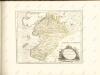

Oldenburg Comit. [Karte], in: Theatrum orbis terrarum, S. 213.
1 Karte aus Atlas Ortelius, Abraham Vrients, Jan Baptista
Paskaart vande Iade, Weser en Elve :
1 : 250000 Mollova mapová sbírka Keulen, Johannes van Keulen, Johannes van

Emden & Olden Borch Comit. [Karte], in: Gerardi Mercatoris Atlas, sive, Cosmographicae meditationes de fabrica mundi et fabricati figura, S. 337.
1 Karte aus Atlas Mercator, Gerhard Montanus, Petrus
Ducatus Bremae & Ferdae maximaeque partis fluminis Visurgis descriptio
1 : 320000 per Fredericum de Witt Amstelodami uytgegeven door Reinier & Josua Ottens, voor aen op den Nieuwendyck in de Warelt [Amsterdam] : ex officina R. & J. Ottens

Ducatus olim episcopatus Bremensis et ostiorum Albis et Visurgis fluviorum, novissima descriptio
1 : 308000 Brémy (Německo : spolková země) Graaf, Cornelius de Ioannes Ianßonius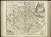
[46][46] Ducatus Bremae & Ferdae ..., uit: Atlas sive Descriptio terrarum orbis
Annotatie: Gedigitaliseerde versie. Amsterdam. Heiloo : Picturae (vervaardiger), 2015. tiff-bestand. Gedigitaliseerd: 07-01-2015; Origineel: Universiteitsbibliotheek Vrije Universiteit (XL.05127.-) ; Netherlands; Titelpagina ontbreekt Wit, Frederik de Amsterdam : Frederick de Wit
DUCATUS BREMAE et FERDAE, Maximaeque partis DUCATUS STORMARIAE, COMITATUS OLDENBURGI, ALBIS, VISURGISQUE FLUMINUM Novissima Descriptio
1 : 330000 Labe-oblast (Česko a Německo) Visscher, Nicolaus per Nicolaum Visscher
Ducatus Bremae et Ferdae nova tabula
1 : 370000 Brémy (Německo : spolková země) Homann, Johann Baptist â Ioh. Bapt. Homanno
Ducatus Bremae et Ferdae nova tabula
1 : 370000 Brémy (Německo : spolková země) Homann, Johann Baptist â Ioh. Bapt. Homanno