Maps of Osteel

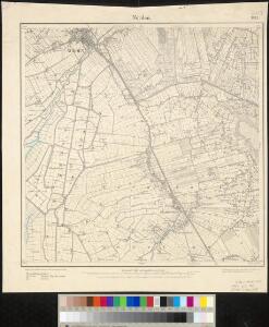
Meßtischblatt 1013 : Norden, 1892
1 : 250000 Norden. - Aufn. 1891. - 1:25000. - [Berlin]: Reichsamt für Landesaufnahme, 1892. - 1 Kt.
Composite: 140. Norden. (Germany)
1 : 100000 Reichsamt fur Landesaufnahme
140. Norden. (Germany)
1 : 100000 Reichsamt fur Landesaufnahme
4me Emden, uit: Nouvelle carte de la Hollande, d'après Kraijenhoff et les meilleures cartes connues / Établissement Géographique de Bruxelles, fondé par Ph. Vander Maelen
1 : 117000 Annotatie: De bladen zijn genummerd 1-24. De bladen 2 t/m 24 hebben elk een afzonderlijke titel. Blad 5 bevat: Triangulations et positions. Blad 9 bevat: Plan d'Amsterdam; De kaartbladen 1, 5, 9 en 24 zijn niet ingekleurd; Van kaartblad 24 is een extra (ingekleurd) exempl. aanwezig; Annotatie geografische gegevens: 2 schaalstokken: 5 Echelle de 5 lieues de 20 au degré ... (= 23,2 cm) en 7380 Echelle de 5 lieues de 20 au degré ... (= 23,2 cm); Legenda; Met indexkaart: Carte d'assemblage Philippe Marie Guillaume Vander Maelen 1795-1869; Établissement Géographique de Bruxelles Bruxelles : Établissement Géographique
2, uit: Topografische atlas van het Koninkrijk der Nederlanden
Annotatie: Map met 19 losse krt. schaal 1:200.000 en 1 bladwijzer schaal 1:1.000.000 ['s-Gravenhage : Ministerie van Oorlog, Topografisch Bureau]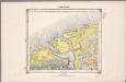
4. Hunsingoo, uit: Geologische kaart van Nederland / door W.C.H. Staring ; bew. aan de Topographische Inrichting
1 : 200000 Winand Carel Hugo Staring 1808-1877; Topographische Inrichting, 's-Gravenhage 's-Gravenhage : Belinfante
37. Norden, uit: Topographische Uebersichtskarte des Deutschen Reiches / herausgegeben v. d. Kartogr. Abt. d. Königl. Preuß. Landesaufnahme
1 : 200000 titelvariant: Topogr. Übersichtskarte des Deutschen Reiches; Annotatie: Titel boven bladen ook: Topogr. Übersichtskarte des Deutschen Reiches; Annotatie geografische gegevens: Op elk blad twee maatstokken: 10 Kilometer = 5,5 cm; 1 geogr. Meile = 3,6 cm; Legenda onder op elk blad Königlich Preußische Landesaufnahme. Kartographische Abtheilung [S.l : Königlich Preußische Landesaufnahme, Kartographische Abtheilung]
Groninga dominivm
1 : 173000 Groningen (Nizozemsko) Wicheringe, Barthold Janssonius, Johannes Ioannes Ianßonius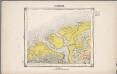
4. Hunsingoo, uit: Geologische kaart van Nederland / door W.C.H. Staring ; bew. aan de Topographische Inrichting
1 : 200000 Winand Carel Hugo Staring 1808-1877; Topographische Inrichting, 's-Gravenhage 's-Gravenhage : Belinfante
Typvs Frisiae Orientalis à Dullarto sinu atque Amasi ostio ad Iada usque fl. singulari studio ac industria concinnat. et vivum expresso
1 : 200000 Mollova mapová sbírka Visscher, Claes Jansz. Visscher, Claes Janszoon
Groninga dominium
1 : 175000 auctore Bartholdo Wicheringe sculpserunt Everardus Sim. Hamers-veldt et Sal. Rogeri. Amstelodami : excudebat Joannes Janssonius
GRONINGA | DOMINIVM
Auctore | Bartholdo Wicheringe [Amsterdam : Joan Blaeu]
GRONINGA | DOMINIVM
Auctore | Bartholdo Wicheringe [Amsterdam : Joan Blaeu]
[Recto], uit: Groninga dominium / auctore Bartholdo Wicheringe ; sculpserunt Everardus Sim. Hamers-veldt, et Sal. Rogeri
1 : 175000 Annotatie: Uit: Gerardi Mercatoris et I. Hondii Atlas ofte Afbeeldinghe vande gantsche Weerldt ... - Amsterdam : Ian Ianssen, 1634 Wicheringe, Bartholdus; Hamersveldt, Everard Symonsz. van; Rogiers, Salomon Amstelodami : excudebat Ioannes Ianssonius
Geographische beschrivinge vande Pr: Stadt Gr. en Oml. : vervattende in sich alle heerlyckheden, fortressen, dorpen, adelycke ende considerabele huysen : met de wapens van de voornaemste ende gequalificeerste adeldom der opgemelte provincie
1 : 90000 naet leven afgeteeckent door de gebroederen W. en F. Conders van Helpen Cornelius Appeus sculpsit. [S.l.] : [s.n.]

Dominii Groningae nec non maximae partis Drentiae Novissima Delineatio
1 : 180000 Mollova mapová sbírka Visscher, Nicolaes Hooghe, Romeyn de Visscher, Nicolaus
Groningen en Ommelanden.
1 : 230000 [François Halma] [Leeuwarden] : [Halma]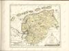

Tabula Frisiae, Groninghae et Territory, Embdensis
1 : 460000 Mollova mapová sbírka Visscher, Nicolaes Goos, Abraham Visscher, Nicolaus I.
Groninga Dominium. [Karte], in: Novus Atlas, das ist, Weltbeschreibung, Bd. 1, S. 414.
1 Karte aus Atlas Blaeu, Joan Blaeu, Willem Janszoon
Groninga Dominium. [Karte], in: Theatrum orbis terrarum, sive, Atlas novus, Bd. 1, S. 450.
1 Karte aus Atlas Blaeu, Joan Blaeu, Willem Janszoon
Emden 31, uit: Special-Karte von Mittel-Europa / nach amtlichen Quellen bearbeitet von W. Liebenow
1 : 300000 titelvariant: W. Liebenow's Mittel-Europa; Annotatie: Titel boven de bladen: W. Liebenow's Mittel-Europa Johannes Wilhelm Liebenow 1822-1897 Frankfurt a. M. : Ludwig Ravenstein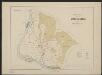
Groninga Dominium. [Karte], in: Gerardi Mercatoris et I. Hondii Newer Atlas, oder, Grosses Weltbuch, Bd. 1, S. 475.
1 Karte aus Atlas Mercator, Gerhard und Hondius, Jodocus Jansson, Jan
Groninga Dominium. [Karte], in: Le théâtre du monde, ou, Nouvel atlas contenant les chartes et descriptions de tous les païs de la terre, Bd. 1, S. 447.
1 Karte aus Atlas Blaeu, Willem Janszoon und Blaeu, Joan Blaeu, Willem Janszoon
Groninga Dominium. [Karte], in: Novus atlas absolutissimus, Bd. 3, S. 226.
1 Karte aus Atlas Janssonius Offizin
Groningen, uit: Sterfte-atlas van Nederland over 1860-1874 / [uitgave van de Nederlandsche Maatschappij tot Bevordering der Geneeskunst]
titelvariant: Sterfte-atlas van Nederland; Annotatie: Alleen kaartbijlage aanwezig Pieter Harmen Witkamp 1816-1892; Nederlandsche Maatschappij tot Bevordering der Geneeskunst Amsterdam : van Rossen
No. VII, uit: Choro-topographische kaart der Noordelijke Provincien van het Koningrijk der Nederlanden / uitgevoerd aan het Topographisch Bureau van dezen staat ; volgens het ontwerp, de geodetische en astronomische waarnemingen van den Luitenant Generaal Baron Krayenhoff
1 : 115200 titelvariant: Generale kaart van het Koningrijk Holland; Chorographische kaart van Holland vereenigd met het Fransche Rijk; Carte chorographique des Departemens de la Hollande; Annotatie: Voor aanwezige bladen zie overzichtsblad; Blad Noord-Brabant ontbreekt Krayenhoff, C. R. T.; Ministerie van Oorlog. Topographisch Bureau ['s-Gravenhage : Archief van Oorlog]
(No. IX), uit: Choro-topographische kaart der Noordelijke Provinciën van het Koningrijk der Nederlanden / uitgevoerd aan het Topographisch Bureau van dezen Staat, volgens het ontwerp, de geodesische en astronomische waarnemingen van Baron Kraijenhoff
1 : 115200 Annotatie: Gestempeld r.o. in rood: AVO (=Archief van Oorlog); Lit.: J.A. van der Linden, Topographische en militaire kaart van het Koningrijk der Nederlanden. Bussum 1973. p. 9-16 & E. ten Brink, De grote kaart van Krayenhoff, speciaal p. 38-39; Op de bladwijzer staat de Hoofddriehoeksmeting aangegeven met de Alphabetische tafel der breedte en lengte van de standplaatsen; Annotatie geografische gegevens: Schaalstok van 27,77 Mylen (Kilomètres) of 7380 Rh. Roeden of 5 Uren (=23,7 cm), op schaal: 800 Rl. Roeden op den Rh. Duim of van 1,152 Myl (Kilomètre) op den Duim (Centimètre); Legenda r.o. op blad VII Topographisch Bureau, Den Haag; Archief van Oorlog, Den Haag ['s-Gravenhage : Topographisch Bureau, Archief van Oorlog]