Maps of Lindetal

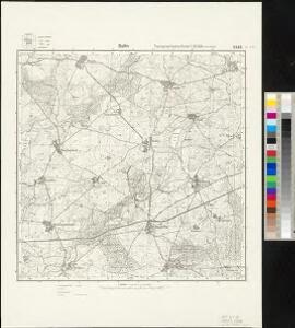
Meßtischblatt 2546 : Ballin, 1955
1 : 250000 Ballin. - Hrsg. 1884.. - 1:25000. - [S.l.]: MdI, 1955. - 1 Kt.
Composite: 185. Woldegk. (Germany)
1 : 100000 Reichsamt fur Landesaufnahme
61. Prenzlau, uit: Topographische Uebersichtskarte des Deutschen Reiches / herausgegeben v. d. Kartogr. Abt. d. Königl. Preuß. Landesaufnahme
1 : 200000 titelvariant: Topogr. Übersichtskarte des Deutschen Reiches; Annotatie: Titel boven bladen ook: Topogr. Übersichtskarte des Deutschen Reiches; Annotatie geografische gegevens: Op elk blad twee maatstokken: 10 Kilometer = 5,5 cm; 1 geogr. Meile = 3,6 cm; Legenda onder op elk blad Königlich Preußische Landesaufnahme. Kartographische Abtheilung [S.l : Königlich Preußische Landesaufnahme, Kartographische Abtheilung]

Insulae Et Principatus Rugiae cum vicinis Pomeraniae Littoribus Nova Tabula
1 : 210000 Mollova mapová sbírka Homann, Johann Baptista - dědici
Eigentliche Abbildung der Pomerischen Insul Rügen : Auf welcher die Dänen und Allűrte, von den Schweden auß Stralsund unversehens überfallen, eine gäntzliche Niederlag erlitten, und dadurch die ganze Insul den Schweden wieder raumen müssen. Geschehen Dienstag den 8. 18. Januarÿ Anno 1678
1 : 185000 Mollova mapová sbírka
Mappa Ducatus Megalopolitani Nova :
1 : 190000 Mollova mapová sbírka
Anklam 35, uit: Special-Karte von Mittel-Europa / nach amtlichen Quellen bearbeitet von W. Liebenow
1 : 300000 titelvariant: W. Liebenow's Mittel-Europa; Annotatie: Titel boven de bladen: W. Liebenow's Mittel-Europa Johannes Wilhelm Liebenow 1822-1897 Frankfurt a. M. : Ludwig Ravenstein
Theatrum belli in Pomerania citeriori
1 : 225000 Mollova mapová sbírka
Theatrum belli in Pomerania Citeriori
1 : 140000 Mollova mapová sbírka
Nieuwe Afteekening van het Eyland Rugen en de Straalsond als mede de Stad Straalsond ent Nieuwe diep met alle desselfs Gelegentheden Int Groot
1 : 170000 Mollova mapová sbírka Keulen, Gerard van Keulen, Gerard van
Eine Accurate Karte Von Pomeren, Wie Auch Dem Landt Rügen, Neben Strahlsundt In Form Seiner Belägerg. : Auch Die Tieffen Des Wasser Mit Sampt Den Grunden
1 : 250000 Mollova mapová sbírka Himmerich, Johann Schenk, Pieter Schenk, Peter II
Rugiae, Usedomiae, Et Iulinae, Wandalicarum insularum vera descriptio. [Karte], in: Theatrum orbis terrarum, S. 209.
1 Karte aus Atlas Ortelius, Abraham Vrients, Jan Baptista

Meklenbvrg Dvcatvs
1 : 520000 Mollova mapová sbírka Lauremberg, Johann Schenk, Peter I
Meklenbvrg Dvcatvs
1 : 520000 Mollova mapová sbírka Lauremberg, Johann Janssonius, Johannes I
Meklenbvrg Dvcatvs
1 : 680000 Mollova mapová sbírka Merian, Matthaeus Merian, Matthäus - dědici
[Operationen der alliirten und französischen Armee 1759]

MARCHIONATUS | BRANDENBURGICI | PARTES DUÆ, | NOVA MARCHIA | et | UCKERANA
Auctore | OLAO JOANNIS GOTHO | Gustaui Magni Cosmographo. [Amsterdam : Joan Blaeu]
Charte von dem Gross-Herzogthümern Mecklenburg-Schwerin, und Mecklenburg-Strelitz
1 : 359000 Meklenbursko (Německo) Streit, Friedrich Wilhelm Friedrich Campe
Das Hertzogthum Mecklenburg in Nieder Sächßischen Creiße Teutschlandes mit seinen abgetheilten Provintzen
1 : 1300000 Mollova mapová sbírka Weigel, Christoph Weigel, Christoph I.
Sect. 8: Schwerin, uit: Geologische Karte des Deutschen Reichs in 27 Blaettern / [von] Richard Lepsius ; Red. von C. Vogel
1 : 500000 Annotatie: Blad 18 ontbreekt; Een aantal bladen op linnen; Een aantal bladen gereviseerd 1913-1914; Annotatie geografische gegevens: Met schaalstokken o.a. in kilometers; Legenda Carl Vogel 1828-1897 Gotha : Justus Perthes
MEKLENBVRG | DVCATVS
Auctore Ioanne Laurenbergio. S. Rogiers sculp [Amsterdam : Joan Blaeu]
Ducatus Meklenburgicus
1 : 460000 Mollova mapová sbírka Ottens, Reinier Ottens, Josua
Il Dvcato di Meklenbvrgo
1 : 450000 Mollova mapová sbírka Cantelli, Giacomo De Rossi, Domenico
Ducatus Meklenburgicus
1 : 460000 Mollova mapová sbírka Wit, Frederik de Covens, Johannes I
Mecklenburg, Schwerin, Strelitz Grossherzogthumer.
1 : 620000 Radefeld, Carl Christian Franz, 1788-1874
Marchia Media Vulgo Mittel Marck in March: Brandenb:
1 : 500000 Mollova mapová sbírka Valk, Gerhard Schenk, Peter I