Maps of Rastdorf

Maps of Rastdorf

$title$

Meßtischblatt 1518 : Neu-Arenberg, 1900

1 : 250000 Neu- Arenberg. - Aufn. 1898. - 1:25000. - [Berlin]: Reichsamt für Landesaufnahme, 1900. - 1 Kt.
$title$

Composite: 232. Sogel.

1 : 100000 Reichsamt fur Landesaufnahme
$title$

232. Sogel.

1 : 100000 Reichsamt fur Landesaufnahme
$title$

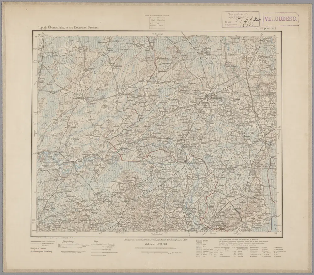
71. Cloppenburg, uit: Topographische Uebersichtskarte des Deutschen Reiches / herausgegeben v. d. Kartogr. Abt. d. Königl. Preuß. Landesaufnahme

1 : 200000 titelvariant: Topogr. Übersichtskarte des Deutschen Reiches; Annotatie: Titel boven bladen ook: Topogr. Übersichtskarte des Deutschen Reiches; Annotatie geografische gegevens: Op elk blad twee maatstokken: 10 Kilometer = 5,5 cm; 1 geogr. Meile = 3,6 cm; Legenda onder op elk blad Königlich Preußische Landesaufnahme. Kartographische Abtheilung [S.l : Königlich Preußische Landesaufnahme, Kartographische Abtheilung]
$title$

Oldenburg Grossherzogthum.

1 : 490000 Gotthard, A.
$title$

$title$

Comitatvvm Oldenbvrg et Delmenhorst

1 : 170000 Mollova mapová sbírka Hunrichs, Johann Wilhelm Anton Homann, Johann Baptista - dědici
$title$

$title$

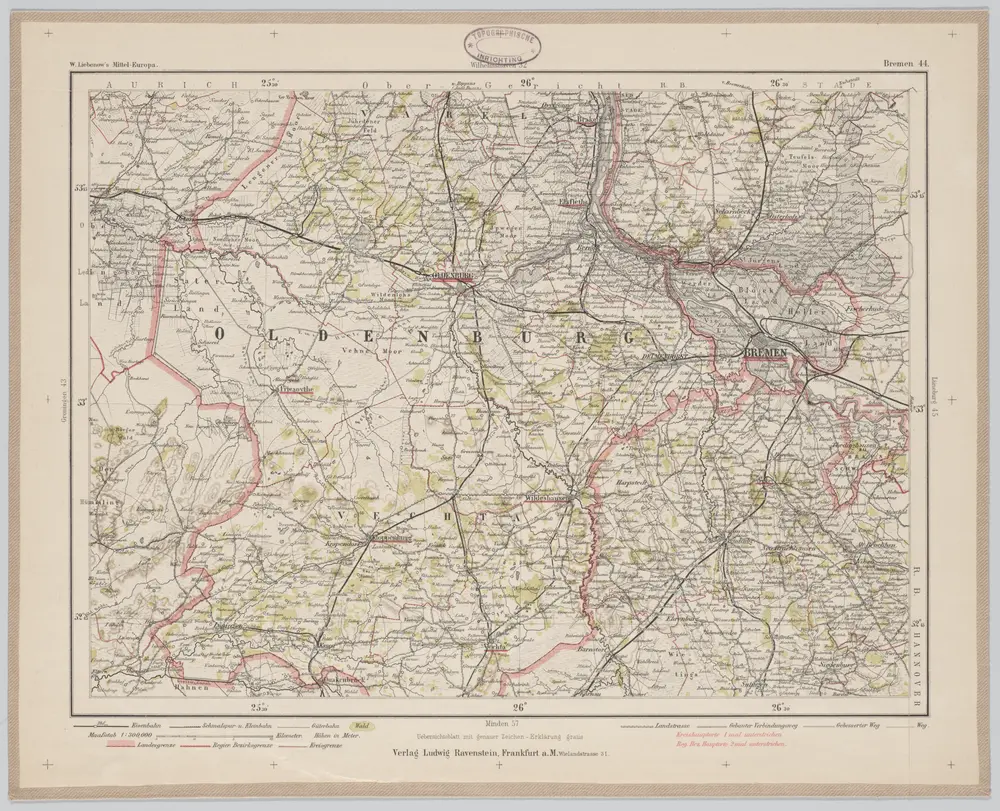
Bremen 44, uit: Special-Karte von Mittel-Europa / nach amtlichen Quellen bearbeitet von W. Liebenow

1 : 300000 titelvariant: W. Liebenow's Mittel-Europa; Annotatie: Titel boven de bladen: W. Liebenow's Mittel-Europa Johannes Wilhelm Liebenow 1822-1897 Frankfurt a. M. : Ludwig Ravenstein
$title$

OLDENBVRG | COMITATVS.

E. Sijmonsz. Hamersveldt sculp. [Amsterdam : Joan Blaeu]
$title$

Oldenburg Comitatus [Karte], in: Theatrum orbis terrarum, sive, Atlas novus, Bd. 1, S. 200.

1 Karte aus Atlas Blaeu, Joan Blaeu, Willem Janszoon
$title$

Oldenburg Comitatus [Karte], in: Gerardi Mercatoris et I. Hondii Newer Atlas, oder, Grosses Weltbuch, Bd. 1, S. 155.

1 Karte aus Atlas Mercator, Gerhard und Hondius, Jodocus Jansson, Jan
$title$

Oldenburg Comitatus [Karte], in: Le théâtre du monde, ou, Nouvel atlas contenant les chartes et descriptions de tous les païs de la terre, Bd. 1, S. 154.

1 Karte aus Atlas Blaeu, Willem Janszoon und Blaeu, Joan Blaeu, Willem Janszoon
$title$

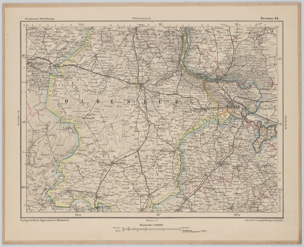
Bremen 44, uit: [W. Liebenow's Special-Karte von Mittel-Europa]

1 : 300000 titelvariant: W. Liebenow's Mittel-Europa; Annotatie: Titel boven de bladen: W. Liebenow's Mittel-Europa Johannes Wilhelm Liebenow 1822-1897 Hannover : Hermann Oppermann
$title$

Oldenburg Comitatus [Karte], in: Novus Atlas, das ist, Weltbeschreibung, Bd. 1, S. 123.

1 Karte aus Atlas Blaeu, Joan Blaeu, Willem Janszoon
$title$

Oldenbvrg Comit.

1 : 250000 Mollova mapová sbírka Michaelis, Laurentius Plantin, Christoph
$title$

Oldenburg Comitatus [Karte], in: Novus atlas absolutissimus, Bd. 2, S. 109.

1 Karte aus Atlas Janssonius Offizin
$title$

Le Theatre de Bellone :

Mollova mapová sbírka Schenk, Pieter Braakman, Adriaan
$title$

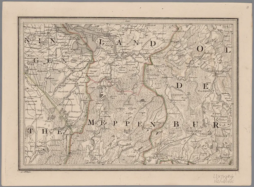
[8], uit: Hydro-Oro und Chorographische General Karte des Koenigreichs der Niederlande und der angrenzenden Länder bis Paris : mit der Angabe der Kunst und Heer-Strassen und der Entfernung der Poststationen / ... zusammengetragen und reducirt von ... Wilhelm Müller

1 : 400000 titelvariant: Generalkarte des Koenigreichs Hannover; Annotatie: 1e supplement bij: Generalkarte des Koenigreichs Hannover (1818) Müller, Wilhelm (fl. 1818) [Hannover : Wilhelm Müller]
$title$

$title$

Oldenbvrg Comitatvs.

1 : 190000 Mollova mapová sbírka Aveele, Johannes van den
$title$

Oldenbvrg Comitatvs

1 : 190000 Mollova mapová sbírka Aveele, Johannes van den
$title$

Comitatus Oldenburgici ac Delmenhorstani Sceptro Danico parentis Mappa specialissima Chorographica, novaq; recentissima

1 : 240000 Mollova mapová sbírka Rizzi Zannoni, Giovanni Antonio Seutter, Albrecht Carl
$title$

Episcopatvs Monasteriensis Pars Septentrionalis

1 : 290000 Mollova mapová sbírka Gigas, Johann Michael
$title$

Episcopatvs Monasteriensis Pars Septentrionalis

1 : 290000 Mollova mapová sbírka Gigas, Johann Michael
$title$

Oldenburg Comit. [Karte], in: Theatrum orbis terrarum, S. 213.

1 Karte aus Atlas Ortelius, Abraham Vrients, Jan Baptista
$title$

Carte topographique d'Allemagne

1 : 214500 Friesland (Německo) Jaeger, Johann Wilhelm Abraham I.W.A. Iaeger
$title$

L'Eveché de Munster Le Comté de Bentheim Tecklenbourg Stenford Lingen, Diepholtz Delmenhorst, Ritberg &c.

1 : 420000 Mollova mapová sbírka Le Rouge, Georges-Louis Le Rouge, Georges-Louis
$title$

Basse Partie de l'Evesché de Munster, et le Comté de Benthem

1 : 300000 Mollova mapová sbírka Sanson, Guillaume Mortier, Pierre
$title$

Emden & Olden Borch Comit. [Karte], in: Gerardi Mercatoris Atlas, sive, Cosmographicae meditationes de fabrica mundi et fabricati figura, S. 337.

1 Karte aus Atlas Mercator, Gerhard Montanus, Petrus
© MapTiler © OpenStreetMap contributors
How does it work?
These instructions will show you how to find historical maps online.
Getting started
Type the place name in the search box to find the exact location. You can further adjust the search by zooming in and out.
Zoom
Zoom in and out with the buttons or use your mouse or touchpad natively.
Exact Area tool
Click here and draw a rectangle over the map to precisely define the search area.
Set filters
Narrow your search with advanced settings, such as Years (from/to), Fulltext, Publisher, etc.
Results
See the results of your search on the right side. You can scroll down to find more maps of this location.
?

Download OldMapsOnline Mobile