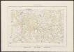
Maps of Bad Wilsnack

Meßtischblatt 3037 : Bad Wilsnack, 1936
1 : 250000 Bad Wilsnack. - Hrsg. 1882, einz. Nachtr. 1932. - 1:25000. - [Berlin]: Reichsamt für Landesaufnahme, 1936. - 1 Kt.
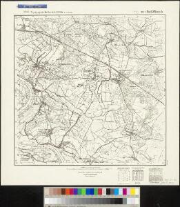
241. Havelberg.
1 : 100000 Reichsamt fur Landesaufnahme
Composite: 241. Havelberg.
1 : 100000 Reichsamt fur Landesaufnahme
75. Stendal, uit: Topographische Uebersichtskarte des Deutschen Reiches / herausgegeben v. d. Kartogr. Abt. d. Königl. Preuß. Landesaufnahme
1 : 200000 titelvariant: Topogr. Übersichtskarte des Deutschen Reiches; Annotatie: Titel boven bladen ook: Topogr. Übersichtskarte des Deutschen Reiches; Annotatie geografische gegevens: Op elk blad twee maatstokken: 10 Kilometer = 5,5 cm; 1 geogr. Meile = 3,6 cm; Legenda onder op elk blad Königlich Preußische Landesaufnahme. Kartographische Abtheilung [S.l : Königlich Preußische Landesaufnahme, Kartographische Abtheilung]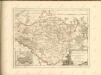

Wittenberge 46, uit: Special-Karte von Mittel-Europa / nach amtlichen Quellen bearbeitet von W. Liebenow
1 : 300000 titelvariant: W. Liebenow's Mittel-Europa; Annotatie: Titel boven de bladen: W. Liebenow's Mittel-Europa Johannes Wilhelm Liebenow 1822-1897 Frankfurt a. M. : Ludwig Ravenstein
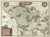
Mappa Ducatus Megalopolitani Nova :
1 : 190000 Mollova mapová sbírka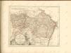
Marchionatvs Brandenburgici
1 : 330000 Mollova mapová sbírka Örnehufvud, Olof Hansson Covens, Johannes I
MARCHIONATUS | BRANDENBURGICI | PARS, quæ | MARCHIA VETUS, | Vulgo | ALTEMARCK, | dicitur.
[Amsterdam : Joan Blaeu]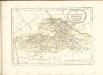

MARCHIONATUS | BRANDENBURGICI | PARTES DUÆ, | RUPPIN | Comitatus | & | PRIGNITS | Regiuncula
Auct. Olao Iohannis Gotho, Gustavo Magno Cosm. [Amsterdam : Joan Blaeu]
Regierungsbezirk Magdeburg Kreiseinteilung 1820
Preußen, Magdeburg, Regierungsbezirk Kunz, Andreas ; Johnen, Bettina ; Moeschl, Joachim
Principatus Anhaldinus Et Magdeburgensis Archiepiscopatus. [Karte], in: Novus atlas absolutissimus, Bd. 2, S. 78.
1 Karte aus Atlas Janssonius Offizin
Berlin - Leipzig - Wittenberge

Marchia Vetus, Vulgo Alte Marck in March: Brandenburgico. [Karte], in: Novus atlas absolutissimus, Bd. 2, S. 57.
1 Karte aus Atlas Janssonius Offizin
Ducatus Meklenburgici Tabula Generalis
1 : 470000 Mollova mapová sbírka Homann, Johann Baptist Homann, Johann Baptista
Sect. 8: Schwerin, uit: Geologische Karte des Deutschen Reichs in 27 Blaettern / [von] Richard Lepsius ; Red. von C. Vogel
1 : 500000 Annotatie: Blad 18 ontbreekt; Een aantal bladen op linnen; Een aantal bladen gereviseerd 1913-1914; Annotatie geografische gegevens: Met schaalstokken o.a. in kilometers; Legenda Carl Vogel 1828-1897 Gotha : Justus Perthes
Il Dvcato di Meklenbvrgo
1 : 450000 Mollova mapová sbírka Cantelli, Giacomo De Rossi, Domenico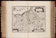
Meklenbvrg dvcatvs / auctore Ioanne Laurenbergio ; S. Rogiers sculp
1 : 450000 Annotatie: Origineel is Blad 84 in atlas factice; Annotatie geografische gegevens: Met 2 schaalstokken Salomon Rogiers ca 1592- v. 1640; Willem Jansz Blaeu 1571-1638 Amstelodami : Guiljelmus Blaeuw excudit
Meklenburg Ducatus [Karte], in: Novus atlas absolutissimus, Bd. 2, S. 39.
1 Karte aus Atlas Janssonius Offizin
Meklenburg Ducatus [Karte], in: Gerardi Mercatoris et I. Hondii Newer Atlas, oder, Grosses Weltbuch, Bd. 1, S. 280.
1 Karte aus Atlas Mercator, Gerhard und Hondius, Jodocus Jansson, Jan
Meklenburg Ducatus. [Karte], in: Novus Atlas, das ist, Weltbeschreibung, Bd. 1, S. 96.
1 Karte aus Atlas Blaeu, Joan Blaeu, Willem Janszoon
[Die Grossherzogthümer Mechlenburg Schwerin und Strelitz]
Grosser Hand-Atlas über alle Theile der Erde in 170 Karten Meyer, J. Verlag des Bibliographischen Instituts
Straßen in den Mecklenburgischen Herzogtümern 1848 (Auswahl)
Mecklenburg Straßennetz Kunz, Andreas ; Treiling, Thomas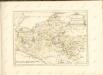

DVCATVS | LVNEBVR | GENSIS | Adiacentiumque regio- | num delineatio
Auctore | IOHANNE MELLIN- | GERO. Amstelodami, | Guiljelm. Blaeuw excudit.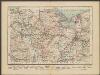
Stettin
1 : 600000 Opitz, Carl Solbrig
Ducatus Luneburgensis Adiacentiumque regionum delineatio. [Karte], in: Novus Atlas, das ist, Weltbeschreibung, Bd. 1, S. 111.
1 Karte aus Atlas Blaeu, Joan Blaeu, Willem Janszoon