Maps of Niederlangen

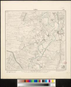
Messtischblatt 1586 : Lathen, 1898 Lathen
1 : 250000 Lathen. - Aufn. 1896, hrsg. 1898. - 1:25000. - [Berlin]: Reichsamt für Landesaufnahme, 1898. - 1 Kt.
Composite: 231. Haren.
1 : 100000 Reichsamt fur Landesaufnahme
231. Haren.
1 : 100000 Reichsamt fur Landesaufnahme
18 Roswinkel, uit: Topographische en militaire kaart van het Koningrijk der Nederlanden / vervaardigd door de officieren van den Generale Staf ; en gegraveerd op het Topographisch Bureau, van het Ministerie van Oorlog
1 : 50000 titelvariant: TMK; Annotatie: Met bladwijzer op schaal 1:600.000. - 1915; Met Verklaring van de topographische en militaire kaart van het Koninkrijk der Nederlanden. - 1910; Bd. 1: titelblad, bladwijzer, verklaring, bladen 1 t/m 32; Bd. 2: bladen 33 t/m 62 Generale Staf, Nederland; Ministerie van Oorlog. Topographisch Bureau ['s-Gravenhage : Ministerie van Oorlog]
[Okolí města Bourtange]
1 : 259600
70. Laar, uit: Topographische Uebersichtskarte des Deutschen Reiches / herausgegeben v. d. Kartogr. Abt. d. Königl. Preuß. Landesaufnahme
1 : 200000 titelvariant: Topogr. Übersichtskarte des Deutschen Reiches; Annotatie: Titel boven bladen ook: Topogr. Übersichtskarte des Deutschen Reiches; Annotatie geografische gegevens: Op elk blad twee maatstokken: 10 Kilometer = 5,5 cm; 1 geogr. Meile = 3,6 cm; Legenda onder op elk blad Königlich Preußische Landesaufnahme. Kartographische Abtheilung [S.l : Königlich Preußische Landesaufnahme, Kartographische Abtheilung]
Drentia comitatvs
Bouttats, Gaspar
Kaart van de provincie Drenthe / door A. Werneke Cz.
1 : 185000 Werneke, A. (Cz.) Te Assen : bij T.J. van Tricht

Kaart of landtafereel der provincie van Groningen en Ommelanden verdeelt in deszelfs byzondere quartieren, districten en voornaamste iurisdictien, beneffens de Heerlykheid Westerwolde
1 : 88000 van nieuws opgenomen, verb. en verm. uitg. door Theodorus Beckeringh , auctor aeri incidit J. van Jagen impressionem direxit. [s.l.] : [s.n.]
Nova totius provinciae Groningo-Omlandiae in Belgio tabula
1 : 190000 J. Bausch sculps. Norimbergae : edentibus Homannianis Heredibus
Groningen 43, uit: [W. Liebenow's Special-Karte von Mittel-Europa]
1 : 300000 titelvariant: W. Liebenow's Mittel-Europa; Annotatie: Titel boven de bladen: W. Liebenow's Mittel-Europa Johannes Wilhelm Liebenow 1822-1897 Hannover : Hermann Oppermann
Groningen 43, uit: Special-Karte von Mittel-Europa / nach amtlichen Quellen bearbeitet von W. Liebenow
1 : 300000 titelvariant: W. Liebenow's Mittel-Europa; Annotatie: Titel boven de bladen: W. Liebenow's Mittel-Europa Johannes Wilhelm Liebenow 1822-1897 Frankfurt a. M. : Ludwig Ravenstein
[8], uit: Hydro-Oro und Chorographische General Karte des Koenigreichs der Niederlande und der angrenzenden Länder bis Paris : mit der Angabe der Kunst und Heer-Strassen und der Entfernung der Poststationen / ... zusammengetragen und reducirt von ... Wilhelm Müller
1 : 400000 titelvariant: Generalkarte des Koenigreichs Hannover; Annotatie: 1e supplement bij: Generalkarte des Koenigreichs Hannover (1818) Müller, Wilhelm (fl. 1818) [Hannover : Wilhelm Müller]
[Zuid-Groningen en Drente]
1 : 100000 [door H.J. Weits (?)]

Le Theatre de Bellone :
Mollova mapová sbírka Schenk, Pieter Braakman, Adriaan
Kaart van Groningen en Drenthe
1 : 500000 volgens de nieuwste en naauwkeurigste stukken zamengesteld en in het koper gebragt door Dl. Veelwaard, Junior. Te Haarlem : bij de Erven F. Bohn
Episcopatvs Monasteriensis Pars Septentrionalis
1 : 290000 Mollova mapová sbírka Gigas, Johann Michael
Episcopatvs Monasteriensis Pars Septentrionalis
1 : 290000 Mollova mapová sbírka Gigas, Johann Michael
Nova totius provinciae Groningo-Omlandiae in Belgio tabula
1 : 200000 Groningen (Nizozemsko) edentibus Homannianis Heredibus
DOMINII FRISIAE tabula, inter FLEVUM et LAVICAM
1 : 150000 Frísko Schotanus, Bernhard Visscher, Nicolaes Jansz. ex officina Nicolai Visscher
DOMINII GRONINGEN nec non maximae partis DRENTIAE
1 : 180000 Gröningen (Německo) Visscher, Nicolaus Hooghe, Romeyn de Nicolaus Visscher excud.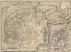
Frisia Occidentalis. [Karte] Antiquae Frisiae situs sub Augusto Imperatore, ut fertur. [Nebenkarten], in: Theatrum orbis terrarum, S. 198.
1 Karte aus Atlas Ortelius, Abraham Vrients, Jan Baptista
La Seigneurie d'Over-Yssel, subdivisée en Trois Parties Sallant, Twente, et Drente
1 : 280000 Mollova mapová sbírka Sanson, Guillaume Mortier, Cornelis
La Seigneurie d'Over-Yssel, subdivisée en Trois Parties Sallant, Twente, et Drente
1 : 280000 Mollova mapová sbírka Sanson, Guillaume Jaillot, Alexis Hubert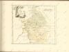

La Seigneurie d'Over-Yssel : subdivisée en trois parties Sallant, Twente, et Drente / dressée sur les memoires les plus nouveaux par le Sr. Sanson
1 : 250000 Annotatie: Uit: Atlas nouveau, contenant toutes les parties du Monde ... Sanson, Guillaume A Paris : chez H. Iaillot
Carte topographique d'Allemagne
1 : 214500 Friesland (Německo) Jaeger, Johann Wilhelm Abraham I.W.A. Iaeger