Maps of Bretsch

Messtischblatt 3135 : Leppin, 1936 Leppin
1 : 250000 Leppin. - Hrsg. 1902, letzte Nachtr. 1932, gedr. [19]36. - 1:25000. - [Berlin]: Reichsamt für Landesaufnahme, 1936. - 1 Kt.
Composite: 240. Seehausen.
1 : 100000 Reichsamt fur Landesaufnahme
240. Seehausen.
1 : 100000 Reichsamt fur Landesaufnahme
75. Stendal, uit: Topographische Uebersichtskarte des Deutschen Reiches / herausgegeben v. d. Kartogr. Abt. d. Königl. Preuß. Landesaufnahme
1 : 200000 titelvariant: Topogr. Übersichtskarte des Deutschen Reiches; Annotatie: Titel boven bladen ook: Topogr. Übersichtskarte des Deutschen Reiches; Annotatie geografische gegevens: Op elk blad twee maatstokken: 10 Kilometer = 5,5 cm; 1 geogr. Meile = 3,6 cm; Legenda onder op elk blad Königlich Preußische Landesaufnahme. Kartographische Abtheilung [S.l : Königlich Preußische Landesaufnahme, Kartographische Abtheilung]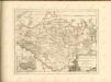

Wittenberge 46, uit: Special-Karte von Mittel-Europa / nach amtlichen Quellen bearbeitet von W. Liebenow
1 : 300000 titelvariant: W. Liebenow's Mittel-Europa; Annotatie: Titel boven de bladen: W. Liebenow's Mittel-Europa Johannes Wilhelm Liebenow 1822-1897 Frankfurt a. M. : Ludwig Ravenstein
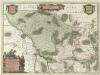
Marchionatvs Brandenburgici
1 : 330000 Mollova mapová sbírka Örnehufvud, Olof Hansson Covens, Johannes I
MARCHIONATUS | BRANDENBURGICI | PARS, quæ | MARCHIA VETUS, | Vulgo | ALTEMARCK, | dicitur.
[Amsterdam : Joan Blaeu]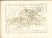

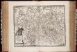
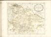
Magdebvrgensis Archiepiscopatvs
1 : 350000 Mollova mapová sbírka Blaeu, Joan Blaeu, Joan I.
MARCHIONATUS | BRANDENBURGICI | PARTES DUÆ, | RUPPIN | Comitatus | & | PRIGNITS | Regiuncula
Auct. Olao Iohannis Gotho, Gustavo Magno Cosm. [Amsterdam : Joan Blaeu]
Regierungsbezirk Magdeburg Kreiseinteilung 1820
Preußen, Magdeburg, Regierungsbezirk Kunz, Andreas ; Johnen, Bettina ; Moeschl, Joachim
Ducatus Luneburgicus cum comitatu Dannebergensi
1 : 336000 Lüneburg (Německo) Seutter, Matthäus Matth. Seutter
Principatus Anhaldinus Et Magdeburgensis Archiepiscopatus. [Karte], in: Novus atlas absolutissimus, Bd. 2, S. 78.
1 Karte aus Atlas Janssonius Offizin
Berlin - Leipzig - Wittenberge

Marchia Vetus, Vulgo Alte Marck in March: Brandenburgico. [Karte], in: Novus atlas absolutissimus, Bd. 2, S. 57.
1 Karte aus Atlas Janssonius Offizin
Map of that part of Hannover where the late battle between the Duke of Cumberland and Marshal D'Etrees was fought July 25, 26, 27
1 : 190080
Sect. 8: Schwerin, uit: Geologische Karte des Deutschen Reichs in 27 Blaettern / [von] Richard Lepsius ; Red. von C. Vogel
1 : 500000 Annotatie: Blad 18 ontbreekt; Een aantal bladen op linnen; Een aantal bladen gereviseerd 1913-1914; Annotatie geografische gegevens: Met schaalstokken o.a. in kilometers; Legenda Carl Vogel 1828-1897 Gotha : Justus Perthes
Saxoniae Tractus Ducatum Magdeburgensem
1 : 370000 Mollova mapová sbírka Homann, Johann Baptist Homann, Johann Baptista
Saxoniae tractus Ducatum Magdeburgensem cum suo circulo Salico princ. Anhaltinum Halberstadiensem finitimarumq. regionum electoratus nempe Brandenburg. Saxoniae ducatus Brunsvicensis etc. partes ostendens
1 : 490000 Anhaltsko (Německo) Homann, Johann Christoph Homannovi dědicové
Saxoniae tractus ducatum Magdeburgensem cum suo circulo Salico princ. Anhaltinum Halberstadiensem finitimarumq. regionum electoratus nempe Brandenburg. Saxoniae ducatus Brunsvicensis etc. partes ostendens
1 : 490000 Anhaltsko (Německo) Homann, Johann Christoph Homannovi dědicové
Dvcatvs Lvnebvrgensis adiacentiumq. regionum delineatio
1 : 487000 Lüneburg (Německo) Mellinger, Johann Janssonius, Johannes apud Ioannem Ianssonium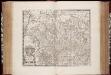
Ducatus Brunsvicensis accuratissima descriptio / apud Janssonio-Waesbergios, Mosem Pitt et Stephanum Swart
1 : 410000 Annotatie: Origineel is Blad 87 in atlas factice; Annotatie geografische gegevens: Met schaalstok: 3 Milliaria Germanica communia; Rechtsboven: XVI Johannes Janssonius van Waesberge -1681?; Moses Pitt ca. 1654-1696; Stephanus Swart [Amstelodamum] : [s.n.]
Straßen in den Mecklenburgischen Herzogtümern 1848 (Auswahl)
Mecklenburg Straßennetz Kunz, Andreas ; Treiling, Thomas
Dvcatvs Lvnebvrgensis
1 : 640000 Mollova mapová sbírka Merian, Matthaeus Merian, Matthäus - dědici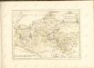

DVCATVS | LVNEBVR | GENSIS | Adiacentiumque regio- | num delineatio
Auctore | IOHANNE MELLIN- | GERO. Amstelodami, | Guiljelm. Blaeuw excudit.