Maps of Löwenberger Land

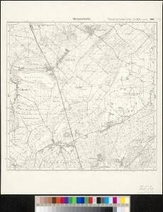
Messtischblatt 3145 : Nassenheide, 1942 Nassenheide
1 : 250000 Nassenheide. - Aufn. 1881, hrsg. 1883, ber. 1940, Ausg. 1940. - 1:25000. - [Berlin]: Reichsamt für Landesaufnahme, 1942. - 1 Kt.
Composite: 243. Oranienburg.
1 : 100000 Reichsamt fur Landesaufnahme
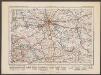
243. Oranienburg.
1 : 100000 Reichsamt fur Landesaufnahme
Le cercle de Glien et de Loewenberg dans la Marche-Moyenne de Brandenbourg
1 : 296000 Braniborsko (Německo) Oesfeld, Karl Ludwig von
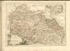
Der Nieder-Barnimsche Creis
1 : 302000 Braniborsko (Německo) Oesfeld, Karl Ludwig von Glassbach, Carl Christian
76. Charlottenburg, uit: Topographische Uebersichtskarte des Deutschen Reiches / herausgegeben v. d. Kartogr. Abt. d. Königl. Preuß. Landesaufnahme
1 : 200000 titelvariant: Topogr. Übersichtskarte des Deutschen Reiches; Annotatie: Titel boven bladen ook: Topogr. Übersichtskarte des Deutschen Reiches; Annotatie geografische gegevens: Op elk blad twee maatstokken: 10 Kilometer = 5,5 cm; 1 geogr. Meile = 3,6 cm; Legenda onder op elk blad Königlich Preußische Landesaufnahme. Kartographische Abtheilung [S.l : Königlich Preußische Landesaufnahme, Kartographische Abtheilung]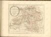

Ruppin 47, uit: Special-Karte von Mittel-Europa / nach amtlichen Quellen bearbeitet von W. Liebenow
1 : 300000 titelvariant: W. Liebenow's Mittel-Europa; Annotatie: Titel boven de bladen: W. Liebenow's Mittel-Europa Johannes Wilhelm Liebenow 1822-1897 Frankfurt a. M. : Ludwig Ravenstein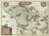
Marchionatvs Brandenburgici
1 : 330000 Mollova mapová sbírka Örnehufvud, Olof Hansson Covens, Johannes I
MARCHIONATUS | BRANDENBURGICI | PARTES DUÆ, | RUPPIN | Comitatus | & | PRIGNITS | Regiuncula
Auct. Olao Iohannis Gotho, Gustavo Magno Cosm. [Amsterdam : Joan Blaeu]
MARCH. BRANDENBURGICI | PARS, quæ | MARCHIA MEDIA | Vulgo MITTELMARCK audit.
Amstelædami, | Excud. Joannes Blaeu.
[Berlin und Umgebung; Die Donau von Paussau bis Wien mit Umgebung]
Stieler's Hand-Atlas Stieler, Adolf bei Justus Perthes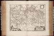
March. Brandenburgici pars, quae Marchia Media vulgo Mittelmarck audit
1 : 400000 Annotatie: Origineel is Blad 91 in atlas factice; Annotatie geografische gegevens: Met schaalstok: Milliaria Germanica Joan Blaeu 1597/98-1673 Amstelaedami : excud. Joannes Blaeu
Berlin - Leipzig - Wittenberge

[Operationen der alliirten und französischen Armee 1759]

MARCHIONATUS | BRANDENBURGICI | PARTES DUÆ, | NOVA MARCHIA | et | UCKERANA
Auctore | OLAO JOANNIS GOTHO | Gustaui Magni Cosmographo. [Amsterdam : Joan Blaeu]
Sect. 8: Schwerin, uit: Geologische Karte des Deutschen Reichs in 27 Blaettern / [von] Richard Lepsius ; Red. von C. Vogel
1 : 500000 Annotatie: Blad 18 ontbreekt; Een aantal bladen op linnen; Een aantal bladen gereviseerd 1913-1914; Annotatie geografische gegevens: Met schaalstokken o.a. in kilometers; Legenda Carl Vogel 1828-1897 Gotha : Justus Perthes
Marchia Media Vulgo Mittel Marck in March: Brandenb:
1 : 500000 Mollova mapová sbírka Valk, Gerhard Schenk, Peter I
Marchia Media Vulgo Mittel Marck in March: Brandenb:
1 : 510000 Mollova mapová sbírka Janssonius, Johannes Janssonius, Johannes I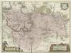
March. Brandenburgici Pars, quae Marchia Media Vulgo Mittesmarck audit
1 : 400000 Mollova mapová sbírka Wit, Frederik de Covens, Johannes I
Straßen in den Mecklenburgischen Herzogtümern 1848 (Auswahl)
Mecklenburg Straßennetz Kunz, Andreas ; Treiling, Thomas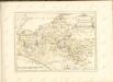
Berlin
1 : 600000 Opitz, Carl Solbrig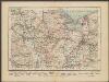
Stettin
1 : 600000 Opitz, Carl Solbrig
Marchia Media; Vulgo Mittel Marck in March: Brandenb: [Karte], in: Novus atlas absolutissimus, Bd. 2, S. 60.
1 Karte aus Atlas Janssonius Offizin
Brandebvrgvm Marchionatvs cum Ducatibus Pomeraniae et Mekelenbvrgi
1 : 1100000 Mollova mapová sbírka Merian, Matthäus Merian, Matthäus - dědici
Pomeraniae Dvcatvs Tabvla
1 : 1100000 Mollova mapová sbírka Merian, Matthäus Merian, Matthäus - dědici
Berlin Varta Wegweiser