Maps of Lähden

Meßtischblatt 1658 : Holte, 1900
1 : 250000 Holte. - Aufn. 1898. - 1:25000. - [Berlin]: Reichsamt für Landesaufnahme, 1900. - 1 Kt.
257. Haselunne.
1 : 100000 Reichsamt fur Landesaufnahme
Composite: 232. Sogel.
1 : 100000 Reichsamt fur Landesaufnahme
71. Cloppenburg, uit: Topographische Uebersichtskarte des Deutschen Reiches / herausgegeben v. d. Kartogr. Abt. d. Königl. Preuß. Landesaufnahme
1 : 200000 titelvariant: Topogr. Übersichtskarte des Deutschen Reiches; Annotatie: Titel boven bladen ook: Topogr. Übersichtskarte des Deutschen Reiches; Annotatie geografische gegevens: Op elk blad twee maatstokken: 10 Kilometer = 5,5 cm; 1 geogr. Meile = 3,6 cm; Legenda onder op elk blad Königlich Preußische Landesaufnahme. Kartographische Abtheilung [S.l : Königlich Preußische Landesaufnahme, Kartographische Abtheilung]
Bremen 44, uit: [W. Liebenow's Special-Karte von Mittel-Europa]
1 : 300000 titelvariant: W. Liebenow's Mittel-Europa; Annotatie: Titel boven de bladen: W. Liebenow's Mittel-Europa Johannes Wilhelm Liebenow 1822-1897 Hannover : Hermann Oppermann
Oldenburg Grossherzogthum.
1 : 490000 Gotthard, A.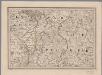
[8], uit: Hydro-Oro und Chorographische General Karte des Koenigreichs der Niederlande und der angrenzenden Länder bis Paris : mit der Angabe der Kunst und Heer-Strassen und der Entfernung der Poststationen / ... zusammengetragen und reducirt von ... Wilhelm Müller
1 : 400000 titelvariant: Generalkarte des Koenigreichs Hannover; Annotatie: 1e supplement bij: Generalkarte des Koenigreichs Hannover (1818) Müller, Wilhelm (fl. 1818) [Hannover : Wilhelm Müller]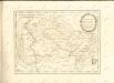

Episcopatvs Monasteriensis Pars Septentrionalis
1 : 290000 Mollova mapová sbírka Gigas, Johann Michael
Episcopatvs Monasteriensis Pars Septentrionalis
1 : 290000 Mollova mapová sbírka Gigas, Johann Michael
Oldenburg Comit. [Karte], in: Theatrum orbis terrarum, S. 213.
1 Karte aus Atlas Ortelius, Abraham Vrients, Jan Baptista
DOMINII GRONINGEN nec non maximae partis DRENTIAE
1 : 180000 Gröningen (Německo) Visscher, Nicolaus Hooghe, Romeyn de Nicolaus Visscher excud.
Carte topographique d'Allemagne
1 : 214500 Friesland (Německo) Jaeger, Johann Wilhelm Abraham I.W.A. Iaeger
L'Eveché de Munster Le Comté de Bentheim Tecklenbourg Stenford Lingen, Diepholtz Delmenhorst, Ritberg &c.
1 : 420000 Mollova mapová sbírka Le Rouge, Georges-Louis Le Rouge, Georges-Louis
Basse Partie de l'Evesché de Munster, et le Comté de Benthem
1 : 300000 Mollova mapová sbírka Sanson, Guillaume Mortier, Pierre
Rev.mo et Seren.mo Principi ac Domo. Dn. Ferdinando Archiep. et Elect. Colon. Episcop. Monasteriens Leto, Duci Bavariae
Mollova mapová sbírka Gigas, Johann Michael
1:250 000 Europe
1 : 250000 Osnabrück (Německo) War Office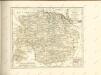

Monasteriensis Episcopatvs
1 : 470000 Mollova mapová sbírka Schenk, Pieter Schenk, Peter I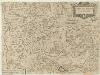
Carta del Vescovato di Mvnster
1 : 450000 Mollova mapová sbírka Hacque, Johann Baptist
Monasteriensis Episcopatus
1 : 460000 Mollova mapová sbírka Hondius, Jodocus Hondius, Jodocus
Monasteriensis Episcopatvs
1 : 460000 Mollova mapová sbírka Gigas, Johann Michael Blaeu, Joan I.
Monasteriensis Episcopatus
1 : 460000 Mollova mapová sbírka Gigas, Johann Michael Blaeu, Willem Jansz.
Basse Partie De L'Evesché De Munster, Et Le Comté De Benthem. [Karte], in: Atlas nouveau, contenant toutes les parties du monde [...], Bd. 1, S. 307.
1 Karte aus Atlas Sanson, Nicolas Jaillot, Alexis Hubert und Mortier, Pieter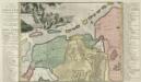
Pars II. et III. Frisiae Libera à Flevo in Lavicam quae Osteresia, atque hinc in Amisiam, quae Groningana cum Transvechtana Dicione Episcopatus Trajectini. Post eluviones seculi XIII
1 : 550000 Mollova mapová sbírka Alting, Menso
Grossherzogthum Oldenburg und Gebiet der freien Stadt Bremen
Grosser Hand-Atlas über alle Theile der Erde in 170 Karten Meyer, J. Verlag des Bibliographischen Instituts
Monasteriensis et Osnabvrgensis episcopatvs descriptio
1 Karte : Kupferdruck ; 36 x 25 cm Mascop; Ortelius s.n.
Monasteriensis et Osnabvrgensis episcopatvs descriptio
1 Karte : Kupferdruck ; 25 x 36 cm Mascop; Ortelius s.n.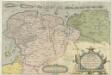
Vtrivsqve Frisiorvm Regionis Noviss: Descriptio
1 : 410000 Mollova mapová sbírka


