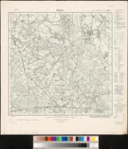
Maps of Warpe

Meßtischblatt 1667 : Bücken. Flecken, 1934
1 : 250000 Bücken Flecken. - Hrsg.1899, einz. Nachtr. 1924, [gedr. 19]34. - 1:25000. - [Berlin]: Reichsamt für Landesaufnahme, 1934. - 1 Kt.
Composite: 235. Verden.
1 : 100000 Reichsamt fur Landesaufnahme
Composite: 260. Nienburg.
1 : 100000 Reichsamt fur Landesaufnahme
235. Verden.
1 : 100000 Reichsamt fur Landesaufnahme
72. Nienburg, uit: Topographische Uebersichtskarte des Deutschen Reiches / herausgegeben v. d. Kartogr. Abt. d. Königl. Preuß. Landesaufnahme
1 : 200000 titelvariant: Topogr. Übersichtskarte des Deutschen Reiches; Annotatie: Titel boven bladen ook: Topogr. Übersichtskarte des Deutschen Reiches; Annotatie geografische gegevens: Op elk blad twee maatstokken: 10 Kilometer = 5,5 cm; 1 geogr. Meile = 3,6 cm; Legenda onder op elk blad Königlich Preußische Landesaufnahme. Kartographische Abtheilung [S.l : Königlich Preußische Landesaufnahme, Kartographische Abtheilung]
Carte topographique d'Allemagne
1 : 225000 Brémy (Německo) Jaeger, Johann Wilhelm Abraham Berndt, Johann Christoph I.W.A. Iaeger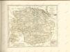

Grossherzogthum Oldenburg und Gebiet der freien Stadt Bremen
Grosser Hand-Atlas über alle Theile der Erde in 170 Karten Meyer, J. Verlag des Bibliographischen Instituts
DUCATUS | BREMÆ & FERDÆ | a Ioanne Gorries Capitaneo Sueco Jußu Com.
Ioan Christoph. a Coningsmarck accuratißime | dimensi & in tabulam redacti. [Amsterdam : Joan Blaeu]
Nova et accurata descriptio ducatus Bremae et Ferdae cum maxima parte finitimi ducatus Stormariensis et comitatus Oldenburgici, itemque fluminum Albis et Visurgis
1 : 336000 Brémy (Německo) Seutter, Matthäus sumptibus Matthaei Seutteri
Dvcatvs Brvnsvicensis fereq. Lvnaeburgensis
1 : 540000 Mollova mapová sbírka Merian, Matthaeus Merian, Matthäus - dědici
Westfalia cum diœcesi Bremensi
1 Karte : Kupferdruck ; 34 x 44 cm Mercator; Hondius sumptibus Henrici Hondij
Westfalia cum diœcesi Bremensi
1 Karte : Kupferdruck ; 34 x 44 cm Mercator; Hondius sumptibus Henrici Hondij
Westfalia cum diœcesi Bremensi
1 Karte : Kupferdruck ; 34 x 44 cm Mercator; Hondius sumptibus Henrici Hondij
Westfalia cum diœcesi Bremensi
1 Karte : Kupferdruck ; 34 x 44 cm Mercator s.n.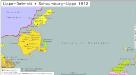
Lippe-Detmold, Schaumburg-Lippe 1812
Lippe-Detmold, Schaumburg-Lippe Hundt, Michael
Ducatvs Brunswicensis, Maximaeq; Partis Luneburgensis, et Episcopatvs Hildesiensis nova & exacta Tabvla
1 : 360000 Mollova mapová sbírka Funck, David Funk, David
Ducatus Brunsvicensis Fereque Lunaeburgensis Cum adiacentibus Episcopatibus, Comitatibus et Dominatibus etc: nova et locupletißima Descriptio Geographica
1 : 360000 Mollova mapová sbírka Visscher, Claes Jansz. Visscher, Claes Janszoon
Map of that part of Hannover where the late battle between the Duke of Cumberland and Marshal D'Etrees was fought July 25, 26, 27
1 : 190080
DVCATVS | BRVNSVICENSIS | fereque | LVNÆBVRGENSIS, | Cum adjacentibus Episcopatibus, Comit. | Domin. etc. | DESCRIPTIO GEOGRAPHICA
per annos aliquot concinnata, et | observato- | re et Elaboratore Casparo Dauthendeij | Architecto et Mathematico Guelphico. [Amsterdam : Joan Blaeu]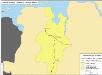
Straßen im Herzogtum Oldenburg 1848 (Auswahl)
Staat Oldenburg Straßennetz Kunz, Andreas ; Treiling, Thomas
Charte von Wesergebirge
1 : 925000
CHARTE von WESERGEBIRGE
1 : 925000 Dolní Sasko (Německo)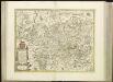
[47][47] Ducatus Brunsvicensis ..., uit: Atlas sive Descriptio terrarum orbis
Annotatie: Gedigitaliseerde versie. Amsterdam. Heiloo : Picturae (vervaardiger), 2015. tiff-bestand. Gedigitaliseerd: 07-01-2015; Origineel: Universiteitsbibliotheek Vrije Universiteit (XL.05127.-) ; Netherlands; Titelpagina ontbreekt Wit, Frederik de Amsterdam : Frederick de Wit
Westl. Theil des Kgr. Hannover (die Landdrosteien Aurich u. Osnabrück) und Grosszhzth. Oldenburg mit F. Lübeck u. F. Birkenfeld
1 : 1150000 E. Luther sc. Gotha : Perthes
Sect. 7: Hamburg, uit: Geologische Karte des Deutschen Reichs in 27 Blaettern / [von] Richard Lepsius ; Red. von C. Vogel
1 : 500000 Annotatie: Blad 18 ontbreekt; Een aantal bladen op linnen; Een aantal bladen gereviseerd 1913-1914; Annotatie geografische gegevens: Met schaalstokken o.a. in kilometers; Legenda Carl Vogel 1828-1897 Gotha : Justus Perthes
Ducatus Brunsvicensis fereque Lunaeburgensis, Cum adjacentibus Episcopatibus, Comit. Domin. etc. [...] [Karte], in: Theatrum orbis terrarum, sive, Atlas novus, Bd. 1, S. 191.
1 Karte aus Atlas Blaeu, Joan Blaeu, Willem Janszoon
Ducatus Brunsvicensis fereque Lunaeburgensis, Cum Adiacentibus Episcopatibus, Comit. Domin. etc. [Karte], in: Le théâtre du monde, ou, Nouvel atlas contenant les chartes et descriptions de tous les païs de la terre, Bd. 1, S. 134.
1 Karte aus Atlas Blaeu, Willem Janszoon und Blaeu, Joan Blaeu, Willem Janszoon