Maps of Samtgemeinde Ahlden

Maps of Samtgemeinde Ahlden

$title$

Meßtischblatt 1670 : Ahlden, 1899

1 : 250000 Ahlden. - Aufn. 1897, hrsg. 1899. - 1:25000. - [Berlin]: Reichsamt für Landesaufnahme, 1899. - 1 Kt.
$title$

Composite: 236. Walsrode.

1 : 100000 Reichsamt fur Landesaufnahme
$title$

236. Walsrode.

1 : 100000 Reichsamt fur Landesaufnahme
$title$

261. Neustadt a. Rubenberge.

1 : 100000 Reichsamt fur Landesaufnahme
$title$

Composite: 261. Neustadt a. Rubenberge.

1 : 100000 Reichsamt fur Landesaufnahme
$title$

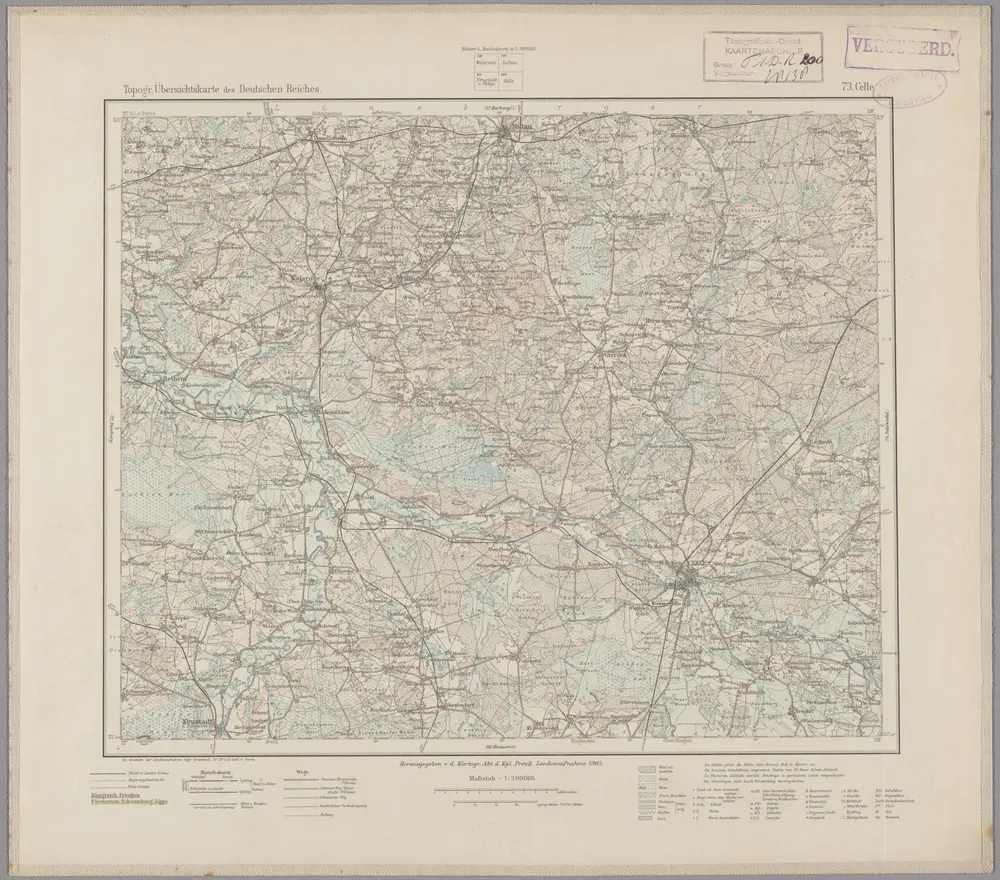
73. Celle, uit: Topographische Uebersichtskarte des Deutschen Reiches / herausgegeben v. d. Kartogr. Abt. d. Königl. Preuß. Landesaufnahme

1 : 200000 titelvariant: Topogr. Übersichtskarte des Deutschen Reiches; Annotatie: Titel boven bladen ook: Topogr. Übersichtskarte des Deutschen Reiches; Annotatie geografische gegevens: Op elk blad twee maatstokken: 10 Kilometer = 5,5 cm; 1 geogr. Meile = 3,6 cm; Legenda onder op elk blad Königlich Preußische Landesaufnahme. Kartographische Abtheilung [S.l : Königlich Preußische Landesaufnahme, Kartographische Abtheilung]
$title$

$title$

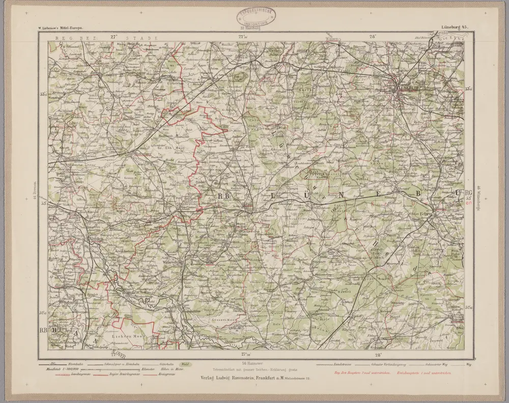
Lüneburg 45, uit: Special-Karte von Mittel-Europa / nach amtlichen Quellen bearbeitet von W. Liebenow

1 : 300000 titelvariant: W. Liebenow's Mittel-Europa; Annotatie: Titel boven de bladen: W. Liebenow's Mittel-Europa Johannes Wilhelm Liebenow 1822-1897 Frankfurt a. M. : Ludwig Ravenstein
$title$

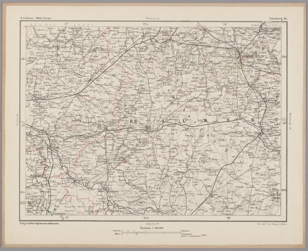
Lüneburg 45, uit: [W. Liebenow's Special-Karte von Mittel-Europa]

1 : 300000 titelvariant: W. Liebenow's Mittel-Europa; Annotatie: Titel boven de bladen: W. Liebenow's Mittel-Europa Johannes Wilhelm Liebenow 1822-1897 Hannover : Hermann Oppermann
$title$

Le Theatre de Bellone :

Mollova mapová sbírka Schenk, Pieter Braakman, Adriaan
$title$

Carte topographique d'Allemagne

1 : 225000 Brémy (Německo) Jaeger, Johann Wilhelm Abraham Berndt, Johann Christoph I.W.A. Iaeger
$title$

$title$

$title$

$title$

DUCATUS | BREMÆ & FERDÆ | a Ioanne Gorries Capitaneo Sueco Jußu Com.

Ioan Christoph. a Coningsmarck accuratißime | dimensi & in tabulam redacti. [Amsterdam : Joan Blaeu]
$title$

Ducatus Luneburgici et comitatus Dannenbergensis

1 : 363000 Lüneburg (Německo) Visscher, Nicolaus Schenk, Pieter Pet. Schenk Iun.
$title$

Ducatus Luneburgici et comitaus Dannebergensis accurata descriptio

1 : 380000 Dolní Sasko (Německo) Homann, Johann Baptist J. B. Homann
$title$

Ducatus Lunenburgensis in omnes ejusdem subjacentes praefecturas Nova descriptio

1 : 870000 Mollova mapová sbírka Danckerts, Justus Danckerts, Justus
$title$

Nova et accurata descriptio ducatus Bremae et Ferdae cum maxima parte finitimi ducatus Stormariensis et comitatus Oldenburgici, itemque fluminum Albis et Visurgis

1 : 336000 Brémy (Německo) Seutter, Matthäus sumptibus Matthaei Seutteri
$title$

$title$

Dvcatvs Brvnsvicensis fereq. Lvnaeburgensis

1 : 540000 Mollova mapová sbírka Merian, Matthaeus Merian, Matthäus - dědici
$title$

Westfalia cum diœcesi Bremensi

1 Karte : Kupferdruck ; 34 x 44 cm Mercator; Hondius sumptibus Henrici Hondij
$title$

Westfalia cum diœcesi Bremensi

1 Karte : Kupferdruck ; 34 x 44 cm Mercator; Hondius sumptibus Henrici Hondij
$title$

Westfalia cum diœcesi Bremensi

1 Karte : Kupferdruck ; 34 x 44 cm Mercator; Hondius sumptibus Henrici Hondij
$title$

Westfalia cum diœcesi Bremensi

1 Karte : Kupferdruck ; 34 x 44 cm Mercator s.n.
$title$

Lippe-Detmold, Schaumburg-Lippe 1812

Lippe-Detmold, Schaumburg-Lippe Hundt, Michael
$title$

Ducatus Luneburgici in suas Praefecturas et Vogteyas ad Statum recentissimum divisi Tabula Geographica

1 : 380000 Mollova mapová sbírka Böhme, August Gottlob Homann, Johann Baptista - dědici
$title$

Ducatvs Brunswicensis, Maximaeq; Partis Luneburgensis, et Episcopatvs Hildesiensis nova & exacta Tabvla

1 : 360000 Mollova mapová sbírka Funck, David Funk, David
$title$

Ducatus Brunsvicensis Fereque Lunaeburgensis Cum adiacentibus Episcopatibus, Comitatibus et Dominatibus etc: nova et locupletißima Descriptio Geographica

1 : 360000 Mollova mapová sbírka Visscher, Claes Jansz. Visscher, Claes Janszoon
$title$

Ducatus Luneburgicus cum Comitatu Dannebergensi juxta Praefecturas suas accurrate designatus et mappa Geographica

1 : 330000 Mollova mapová sbírka Seutter, Matthäus Seutter, Matthäus
$title$

Ducatus Luneburgici et Dannebergensis Comitatus

1 : 330000 Mollova mapová sbírka Wit, Frederik de Covens, Johannes I
$title$

Ducatus Luneburgici et Comitatus Dannebergensis accurata Descriptio

1 : 360000 Mollova mapová sbírka Homann, Johann Baptist Homann, Johann Baptista
© MapTiler © OpenStreetMap contributors
How does it work?
These instructions will show you how to find historical maps online.
Getting started
Type the place name in the search box to find the exact location. You can further adjust the search by zooming in and out.
Zoom
Zoom in and out with the buttons or use your mouse or touchpad natively.
Exact Area tool
Click here and draw a rectangle over the map to precisely define the search area.
Set filters
Narrow your search with advanced settings, such as Years (from/to), Fulltext, Publisher, etc.
Results
See the results of your search on the right side. You can scroll down to find more maps of this location.
?

Download OldMapsOnline Mobile