Maps of Fleetmark

Meßtischblatt 1681 : Jeetze, 1932
1 : 250000 Jeetze. - Hrsg. 1902, einz. Nachtr. 1932. - 1:25000. - [Berlin]: Reichsamt für Landesaufnahme, 1932. - 1 Kt.
Composite: 265. Gardelegen.
1 : 100000 Reichsamt fur Landesaufnahme
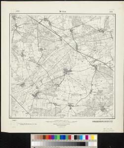
265. Gardelegen.
1 : 100000 Reichsamt fur Landesaufnahme
240. Seehausen.
1 : 100000 Reichsamt fur Landesaufnahme
75. Stendal, uit: Topographische Uebersichtskarte des Deutschen Reiches / herausgegeben v. d. Kartogr. Abt. d. Königl. Preuß. Landesaufnahme
1 : 200000 titelvariant: Topogr. Übersichtskarte des Deutschen Reiches; Annotatie: Titel boven bladen ook: Topogr. Übersichtskarte des Deutschen Reiches; Annotatie geografische gegevens: Op elk blad twee maatstokken: 10 Kilometer = 5,5 cm; 1 geogr. Meile = 3,6 cm; Legenda onder op elk blad Königlich Preußische Landesaufnahme. Kartographische Abtheilung [S.l : Königlich Preußische Landesaufnahme, Kartographische Abtheilung]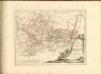

Wittenberge 46, uit: Special-Karte von Mittel-Europa / nach amtlichen Quellen bearbeitet von W. Liebenow
1 : 300000 titelvariant: W. Liebenow's Mittel-Europa; Annotatie: Titel boven de bladen: W. Liebenow's Mittel-Europa Johannes Wilhelm Liebenow 1822-1897 Frankfurt a. M. : Ludwig Ravenstein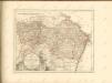
Marchionatvs Brandenburgici
1 : 330000 Mollova mapová sbírka Örnehufvud, Olof Hansson Covens, Johannes I
MARCHIONATUS | BRANDENBURGICI | PARS, quæ | MARCHIA VETUS, | Vulgo | ALTEMARCK, | dicitur.
[Amsterdam : Joan Blaeu]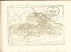
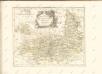

Magdebvrgensis Archiepiscopatvs
1 : 350000 Mollova mapová sbírka Blaeu, Joan Blaeu, Joan I.
MARCHIONATUS | BRANDENBURGICI | PARTES DUÆ, | RUPPIN | Comitatus | & | PRIGNITS | Regiuncula
Auct. Olao Iohannis Gotho, Gustavo Magno Cosm. [Amsterdam : Joan Blaeu]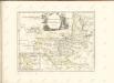

MAGDEBVRGENSIS | ARCHIEPISCOPATVS.
Amstelædami | J. Blaeu excudebat.

Geographische Charte des Hertzogthums und Halle Nebst etlichen angräntzende Orthen und Fürstenthume Gestochen
1 : 310000 Mollova mapová sbírka Schenk, Pieter Schenk, Peter II
Ducatus Magdeburgensis et Halensis cum finitimis Delineatio geographica curante
1 : 320000 Mollova mapová sbírka Seutter, Matthäus Lotter, Tobias Conrad Seutter, Matthäus
Das Hertzogthum Magdeburg mit seinen abgetheilten Provintzien
1 : 930000 Mollova mapová sbírka Weigel, Johann Christoph Weigel, Johann Christoph
Regierungsbezirk Magdeburg Kreiseinteilung 1820
Preußen, Magdeburg, Regierungsbezirk Kunz, Andreas ; Johnen, Bettina ; Moeschl, Joachim
Ducatus Luneburgicus cum comitatu Dannebergensi
1 : 336000 Lüneburg (Německo) Seutter, Matthäus Matth. Seutter

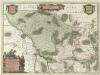
Principatus Anhaldinus Et Magdeburgensis Archiepiscopatus. [Karte], in: Novus atlas absolutissimus, Bd. 2, S. 78.
1 Karte aus Atlas Janssonius Offizin
Ducatus Luneburgici et comitatus Dannenbergensis
1 : 363000 Lüneburg (Německo) Visscher, Nicolaus Schenk, Pieter Pet. Schenk Iun.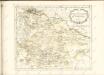

Marchia Vetus, Vulgo Alte Marck in March: Brandenburgico. [Karte], in: Novus atlas absolutissimus, Bd. 2, S. 57.
1 Karte aus Atlas Janssonius Offizin
Dvcatvs Brvnsvicensis fereq. Lvnaeburgensis
1 : 540000 Mollova mapová sbírka Merian, Matthaeus Merian, Matthäus - dědici
Ducatus Luneburgici in suas Praefecturas et Vogteyas ad Statum recentissimum divisi Tabula Geographica
1 : 380000 Mollova mapová sbírka Böhme, August Gottlob Homann, Johann Baptista - dědici
Ducatus Luneburgicus cum Comitatu Dannebergensi juxta Praefecturas suas accurrate designatus et mappa Geographica
1 : 330000 Mollova mapová sbírka Seutter, Matthäus Seutter, Matthäus
Ducatus Luneburgici et Dannebergensis Comitatus
1 : 330000 Mollova mapová sbírka Wit, Frederik de Covens, Johannes I