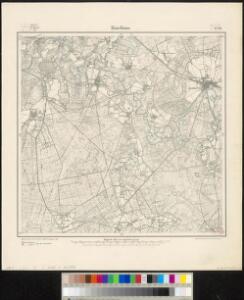
Maps of Haselünne

Meßtischblatt 1729 : Haselünne, 1900
1 : 250000 Haselünne. - Aufn. 1898, hrsg. 1900. - 1:25000. - [Berlin]: Reichsamt für Landesaufnahme, 1900. - 1 Kt.
Composite: 257. Haselunne.
1 : 100000 Reichsamt fur Landesaufnahme
257. Haselunne.
1 : 100000 Reichsamt fur Landesaufnahme
71. Cloppenburg, uit: Topographische Uebersichtskarte des Deutschen Reiches / herausgegeben v. d. Kartogr. Abt. d. Königl. Preuß. Landesaufnahme
1 : 200000 titelvariant: Topogr. Übersichtskarte des Deutschen Reiches; Annotatie: Titel boven bladen ook: Topogr. Übersichtskarte des Deutschen Reiches; Annotatie geografische gegevens: Op elk blad twee maatstokken: 10 Kilometer = 5,5 cm; 1 geogr. Meile = 3,6 cm; Legenda onder op elk blad Königlich Preußische Landesaufnahme. Kartographische Abtheilung [S.l : Königlich Preußische Landesaufnahme, Kartographische Abtheilung]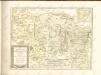

Comitatus Bentheim, et Steinfurt. [Karte], in: Novus atlas absolutissimus, Bd. 2, S. 121.
1 Karte aus Atlas Janssonius Offizin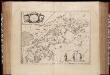
Comitatus Bentheim, et Steinfurt / auctore Ioanne Westenberg ; [Willem Jansz. Blaeu]
1 : 230000 Annotatie: Het eerst verschenen in: Ander Theil Novi Atlantis ... - Amsterdami : apud Guiljelmum et Johannem Blaeu, 1635; Origineel is Blad 78 in atlas factice; Annotatie geografische gegevens: Oost boven Westenberg, Johannes; Blaeu, Willem Jansz. [Amsterdam : Guljelm. Blaeu excudebat]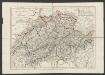
Comitatus Bentheimensis Nova Descriptio [Karte], in: Gerardi Mercatoris et I. Hondii Newer Atlas, oder, Grosses Weltbuch, Bd. 1, S. 173.
1 Karte aus Atlas Mercator, Gerhard und Hondius, Jodocus Jansson, Jan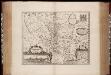
Osnabrugensis episcopatus / auctore Ioanne Gigante ; [Willem Jansz. Blaeu]
1 : 250000 Annotatie: Bij deze 2e staat zijn de lengtegraden in de kaartrand veranderd van O 28°40'-30°20' in O 25°20'-26°50'; Origineel is Blad 77 in atlas factice; Oorspr. uitg.: Atlantis appendix, sive pars altera ... - Amsterdami : apud Guiljelmum Blaeuw, 1630 Gigas, Joannes (1580-1650); Blaeu, Willem Jansz. Amstelodami : Guiljelm. Blaeu excudit [i.e. Joan Blaeu]
Osnabrvgensis Episcopatvs
1 : 470000 Mollova mapová sbírka Gigas, Johann Michael Schenk, Peter I
Osnabrvgensis Episcopatvs
1 : 470000 Mollova mapová sbírka Gigas, Johann Michael
Osnabrugensis Episcopatus. [Karte] Districtus Reckenbergensis. [Nebenkarte], in: Novus atlas absolutissimus, Bd. 2, S. 115.
1 Karte aus Atlas Janssonius Offizin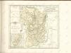
Osnabrugensis Episcopatus. [Karte] Districtus Reckenbergensis. [Nebenkarte], in: Le théâtre du monde, ou, Nouvel atlas contenant les chartes et descriptions de tous les païs de la terre, Bd. 1, S. 166.
1 Karte aus Atlas Blaeu, Willem Janszoon und Blaeu, Joan Blaeu, Willem Janszoon
Osnabrugensis Episcopatus. [Karte] Districtus Reckenbergensis. [Nebenkarte], in: Novus Atlas, das ist, Weltbeschreibung, Bd. 1, S. 135.
1 Karte aus Atlas Blaeu, Joan Blaeu, Willem Janszoon
Osnabrugensis Episcopatus. [Karte] Districtus Reckenbergensis. [Nebenkarte], in: Gerardi Mercatoris et I. Hondii Newer Atlas, oder, Grosses Weltbuch, Bd. 1, S. 170.
1 Karte aus Atlas Mercator, Gerhard und Hondius, Jodocus Jansson, Jan
Osnabrvgensis episcopatvs
1 : 236000 Osnabrück (Německo) Gigas, Johann Michael Blaeu, Willem Janszoon Guilielm Blaeuw
Osnabrugensis Episcopatus. [Karte] Districtus Reckenbergergensis. [1 Nebenkarte], in: Theatrum orbis terrarum, sive, Atlas novus, Bd. 1, S. 206.
1 Karte aus Atlas Blaeu, Joan Blaeu, Willem Janszoon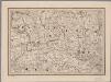
[12], uit: Hydro-Oro und Chorographische General Karte des Koenigreichs der Niederlande und der angrenzenden Länder bis Paris : mit der Angabe der Kunst und Heer-Strassen und der Entfernung der Poststationen / ... zusammengetragen und reducirt von ... Wilhelm Müller
1 : 400000 titelvariant: Generalkarte des Koenigreichs Hannover; Annotatie: 1e supplement bij: Generalkarte des Koenigreichs Hannover (1818) Müller, Wilhelm (fl. 1818) [Hannover : Wilhelm Müller]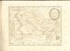

Le Theatre de Bellone :
Mollova mapová sbírka Schenk, Pieter Braakman, Adriaan
Kaart van Groningen en Drenthe
1 : 500000 volgens de nieuwste en naauwkeurigste stukken zamengesteld en in het koper gebragt door Dl. Veelwaard, Junior. Te Haarlem : bij de Erven F. Bohn
Episcopatvs Monasteriensis Pars Septentrionalis
1 : 290000 Mollova mapová sbírka Gigas, Johann Michael
Episcopatvs Monasteriensis Pars Septentrionalis
1 : 290000 Mollova mapová sbírka Gigas, Johann Michael
Nova totius provinciae Groningo-Omlandiae in Belgio tabula
1 : 200000 Groningen (Nizozemsko) edentibus Homannianis Heredibus
DOMINII GRONINGEN nec non maximae partis DRENTIAE
1 : 180000 Gröningen (Německo) Visscher, Nicolaus Hooghe, Romeyn de Nicolaus Visscher excud.
Carte topographique d'Allemagne
1 : 214500 Friesland (Německo) Jaeger, Johann Wilhelm Abraham I.W.A. Iaeger
TRANSISELANIA | DOMINIVM | vernaculè | OVER-YSSEL.
[Amsterdam : Joan Blaeu]
L'Eveché de Munster Le Comté de Bentheim Tecklenbourg Stenford Lingen, Diepholtz Delmenhorst, Ritberg &c.
1 : 420000 Mollova mapová sbírka Le Rouge, Georges-Louis Le Rouge, Georges-Louis