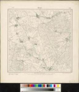
Maps of Lüdelsen

Meßtischblatt 1750 : Brome, 1902
1 : 250000 Brome. - Aufn. 1900. - 1:25000. - [Berlin]: Reichsamt für Landesaufnahme, 1902. - 1 Kt.
264. Klotze.
1 : 100000 Reichsamt fur Landesaufnahme
263. Wittingen.
1 : 100000 Reichsamt fur Landesaufnahme
74. Salzwedel, uit: Topographische Uebersichtskarte des Deutschen Reiches / herausgegeben v. d. Kartogr. Abt. d. Königl. Preuß. Landesaufnahme
1 : 200000 titelvariant: Topogr. Übersichtskarte des Deutschen Reiches; Annotatie: Titel boven bladen ook: Topogr. Übersichtskarte des Deutschen Reiches; Annotatie geografische gegevens: Op elk blad twee maatstokken: 10 Kilometer = 5,5 cm; 1 geogr. Meile = 3,6 cm; Legenda onder op elk blad Königlich Preußische Landesaufnahme. Kartographische Abtheilung [S.l : Königlich Preußische Landesaufnahme, Kartographische Abtheilung]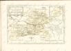

Carte topographique d'Allemagne
1 : 214500 Braniborsko (Německo) Jaeger, Johann Wilhelm Abraham Berndt, Johann Christoph I.W.A. Iaeger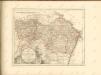

MARCHIONATUS | BRANDENBURGICI | PARS, quæ | MARCHIA VETUS, | Vulgo | ALTEMARCK, | dicitur.
[Amsterdam : Joan Blaeu]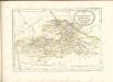
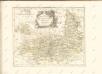

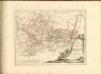
MAGDEBVRGENSIS | ARCHIEPISCOPATVS.
Amstelædami | J. Blaeu excudebat.

Regierungsbezirk Magdeburg Kreiseinteilung 1820
Preußen, Magdeburg, Regierungsbezirk Kunz, Andreas ; Johnen, Bettina ; Moeschl, Joachim
Ducatus Luneburgicus cum comitatu Dannebergensi
1 : 336000 Lüneburg (Německo) Seutter, Matthäus Matth. Seutter

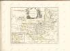
Principatus Anhaldinus Et Magdeburgensis Archiepiscopatus. [Karte], in: Novus atlas absolutissimus, Bd. 2, S. 78.
1 Karte aus Atlas Janssonius Offizin
Ducatus Luneburgici et comitatus Dannenbergensis
1 : 363000 Lüneburg (Německo) Visscher, Nicolaus Schenk, Pieter Pet. Schenk Iun.
Ducatus Luneburgici et comitaus Dannebergensis accurata descriptio
1 : 380000 Dolní Sasko (Německo) Homann, Johann Baptist J. B. Homann
Geographische Lage der südlichen Braunschweigischen Reichsgebiete darinnen
1 : 280000 Mollova mapová sbírka Homann, Johann Baptist Homann, Johann Baptista - dědici
Ducatus Lunenburgensis in omnes ejusdem subjacentes praefecturas Nova descriptio
1 : 870000 Mollova mapová sbírka Danckerts, Justus Danckerts, Justus
Ducatus Brunsuicensis
1 : 400000 Braunschweig (Německo : historické území) Homann, Johann Baptist Ioh. Bapt. Homanni
Ducatus Brunsuicensis in Eiusdem tres Principatus Calenbergicum Scilicet et Grubenhagensem
1 : 360000 Mollova mapová sbírka Wit, Frederik de Covens, Johannes I
Ducatus Brunsuicensis in Eiusdem tres Principatus Calenbergicum Scilicet et Grubenhagensem
1 : 380000 Mollova mapová sbírka Schenk, Pieter Schenk, Peter I
Ducatus Brunsuicensis Episcopatus Hildesiensis Principatus Halberstadiensis Tabula
1 : 370000 Mollova mapová sbírka Danckerts, Justus Danckerts, Justus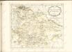

Marchia Vetus, Vulgo Alte Marck in March: Brandenburgico. [Karte], in: Novus atlas absolutissimus, Bd. 2, S. 57.
1 Karte aus Atlas Janssonius Offizin
Ducatus Brunsuicensis juxta tres suos Principatus Calenbergic. nimir. et Grubenhagens.
1 : 385000 Mollova mapová sbírka Seutter, Matthäus Seutter, Matthäus
Ducatus Brunsuicensis in tres suos Principatus Calenbergicum sc. Grubenhag & Guelpherbitanum distincte divisi, nec non Episcopatus Hildesiensis, Pr. Halber. Comitatus Schauenburgici, aliorumq; confiniorum exacta Tabula
1 : 380000 Mollova mapová sbírka Homann, Johann Baptist Homann, Johann Baptista