Maps of Milower Land

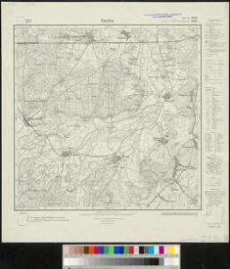
Meßtischblatt 1830, neue Nr. 3439 : Vieritz, 1932
1 : 250000 Vieritz. - Hrsg. 1882, einz. Nachtr. 1932. - 1:25000. - [Berlin]: Reichsamt für Landesaufnahme, 1932. - 1 Kt.
266. Stendal.
1 : 100000 Reichsamt fur Landesaufnahme
Composite: 266. Stendal.
1 : 100000 Reichsamt fur Landesaufnahme
75. Stendal, uit: Topographische Uebersichtskarte des Deutschen Reiches / herausgegeben v. d. Kartogr. Abt. d. Königl. Preuß. Landesaufnahme
1 : 200000 titelvariant: Topogr. Übersichtskarte des Deutschen Reiches; Annotatie: Titel boven bladen ook: Topogr. Übersichtskarte des Deutschen Reiches; Annotatie geografische gegevens: Op elk blad twee maatstokken: 10 Kilometer = 5,5 cm; 1 geogr. Meile = 3,6 cm; Legenda onder op elk blad Königlich Preußische Landesaufnahme. Kartographische Abtheilung [S.l : Königlich Preußische Landesaufnahme, Kartographische Abtheilung]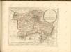

MARCHIONATUS | BRANDENBURGICI | PARS, quæ | MARCHIA VETUS, | Vulgo | ALTEMARCK, | dicitur.
[Amsterdam : Joan Blaeu]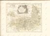

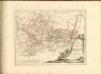
Magdebvrgensis Archiepiscopatvs
1 : 350000 Mollova mapová sbírka Blaeu, Joan Blaeu, Joan I.
Geographische Charte des Herzogthums Magdenburg und Halle
1 : 308000 Halle an der Saale-oblast (Německo) Schenk, Pieter P. Schenk
Geographische Charte des Herzogthums Magdenburg und Halle
1 : 308000 Halle an der Saale-oblast (Německo) Schenk, Pieter P. Schenk
Geographische Charte des Herzogthums Magdenburg und Halle
1 : 308000 Halle an der Saale-oblast (Německo) Schenk, Pieter P. Schenk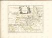

MAGDEBVRGENSIS | ARCHIEPISCOPATVS.
Amstelædami | J. Blaeu excudebat.
Episcopatus Halberstadensis Descriptio nova. [Karte], in: Novus atlas absolutissimus, Bd. 2, S. 89.
1 Karte aus Atlas Janssonius Offizin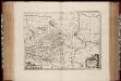
Episcopatvs Halberstadensis descriptio nova / Paullus de Zetter, fe
1 : 410000 Annotatie: Origineel is Blad 89 in atlas factice; Annotatie geografische gegevens: Schaalvermelding op kaart: 3 Milliaria Germanica communia; Nummering rechtsboven: XVIII Paullus de Zetter [Amstelodami : Ex Officina Janssonio-Waesbergiana, Mosis Pitt et Stephani Swart]
MARCH. BRANDENBURGICI | PARS, quæ | MARCHIA MEDIA | Vulgo MITTELMARCK audit.
Amstelædami, | Excud. Joannes Blaeu.
Geographische Charte des Hertzogthums und Halle Nebst etlichen angräntzende Orthen und Fürstenthume Gestochen
1 : 310000 Mollova mapová sbírka Schenk, Pieter Schenk, Peter II
Ducatus Magdeburgensis et Halensis cum finitimis Delineatio geographica curante
1 : 320000 Mollova mapová sbírka Seutter, Matthäus Lotter, Tobias Conrad Seutter, Matthäus
Das Hertzogthum Magdeburg mit seinen abgetheilten Provintzien
1 : 930000 Mollova mapová sbírka Weigel, Johann Christoph Weigel, Johann Christoph
[Berlin und Umgebung; Die Donau von Paussau bis Wien mit Umgebung]
Stieler's Hand-Atlas Stieler, Adolf bei Justus Perthes
Regierungsbezirk Magdeburg Kreiseinteilung 1820
Preußen, Magdeburg, Regierungsbezirk Kunz, Andreas ; Johnen, Bettina ; Moeschl, Joachim
Principatus Anhaldinus Et Magdeburgensis Archiepiscopatus. [Karte], in: Novus atlas absolutissimus, Bd. 2, S. 78.
1 Karte aus Atlas Janssonius Offizin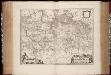
March. Brandenburgici pars, quae Marchia Media vulgo Mittelmarck audit
1 : 400000 Annotatie: Origineel is Blad 91 in atlas factice; Annotatie geografische gegevens: Met schaalstok: Milliaria Germanica Joan Blaeu 1597/98-1673 Amstelaedami : excud. Joannes Blaeu
Berlin - Leipzig - Wittenberge

Marchia Vetus, Vulgo Alte Marck in March: Brandenburgico. [Karte], in: Novus atlas absolutissimus, Bd. 2, S. 57.
1 Karte aus Atlas Janssonius Offizin
Map of that part of Hannover where the late battle between the Duke of Cumberland and Marshal D'Etrees was fought July 25, 26, 27
1 : 190080
Sect. 14: Berlin, uit: Geologische Karte des Deutschen Reichs in 27 Blaettern / [von] Richard Lepsius ; Red. von C. Vogel
1 : 500000 Annotatie: Blad 18 ontbreekt; Een aantal bladen op linnen; Een aantal bladen gereviseerd 1913-1914; Annotatie geografische gegevens: Met schaalstokken o.a. in kilometers; Legenda Carl Vogel 1828-1897 Gotha : Justus Perthes
Saxoniae Tractus Ducatum Magdeburgensem
1 : 370000 Mollova mapová sbírka Homann, Johann Baptist Homann, Johann Baptista
Saxoniae tractus Ducatum Magdeburgensem cum suo circulo Salico princ. Anhaltinum Halberstadiensem finitimarumq. regionum electoratus nempe Brandenburg. Saxoniae ducatus Brunsvicensis etc. partes ostendens
1 : 490000 Anhaltsko (Německo) Homann, Johann Christoph Homannovi dědicové