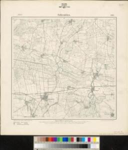
Maps of Weyhausen

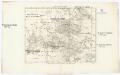
Meßtischblatt 1892, neue Nr. 3530 : Fallersleben, 1938
1 : 250000 Fallersleben. - Hrsg. 1901, bericht. 1924, einz. Nachtr. 1936, gedr. [19]38. - 1:25000. - [Berlin]: Reichsamt für Landesaufnahme, 1938. - 1 Kt.
Meßtischblatt 1892 : Fallersleben, 1901
1 : 250000 Fallersleben. - Aufn. 1899. - 1:25000. - [Berlin]: Reichsamt für Landesaufnahme, 1901. - 1 Kt.
Composite: 288. Braunschweig.
1 : 100000 Reichsamt fur Landesaufnahme
288. Braunschweig.
1 : 100000 Reichsamt fur Landesaufnahme
87. Braunschweig, uit: Topographische Uebersichtskarte des Deutschen Reiches / herausgegeben v. d. Kartogr. Abt. d. Königl. Preuß. Landesaufnahme
1 : 200000 titelvariant: Topogr. Übersichtskarte des Deutschen Reiches; Annotatie: Titel boven bladen ook: Topogr. Übersichtskarte des Deutschen Reiches; Annotatie geografische gegevens: Op elk blad twee maatstokken: 10 Kilometer = 5,5 cm; 1 geogr. Meile = 3,6 cm; Legenda onder op elk blad Königlich Preußische Landesaufnahme. Kartographische Abtheilung [S.l : Königlich Preußische Landesaufnahme, Kartographische Abtheilung]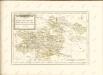

Magdeburg 59, uit: Special-Karte von Mittel-Europa / nach amtlichen Quellen bearbeitet von W. Liebenow
1 : 300000 titelvariant: W. Liebenow's Mittel-Europa; Annotatie: Titel boven de bladen: W. Liebenow's Mittel-Europa Johannes Wilhelm Liebenow 1822-1897 Frankfurt a. M. : Ludwig Ravenstein
MARCHIONATUS | BRANDENBURGICI | PARS, quæ | MARCHIA VETUS, | Vulgo | ALTEMARCK, | dicitur.
[Amsterdam : Joan Blaeu]
Episcopatus Hildesiensis nec non Vicinorum Statuum delineatio Geographica
1 : 290000 Mollova mapová sbírka Arenhold, Gerard J. Schneider, Ruprecht Adam Homann, Johann Baptista - dědici
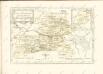
EPISCOPATVS | HALBERSTAT.
Amstlædami apud Joannem Blaeu.
Episcopatus Hildesiensis nec non vicinorum statuum delineatio geographica
1 : 287000 Hildesheim (Německo) Arenhold, Gerhard Justus Haered. Ioh. Baptist. Homanni
Episcopatus Hildesiensis nec non vicinorum statuum delineatio geographica
1 : 287000 Hildesheim (Německo) Arenhold, Gerhard Justus Haered. Ioh. Baptist. Homanni
Episcopatus Hildesiensis Descriptio Novissima [Karte], in: Le théâtre du monde, ou, Nouvel atlas contenant les chartes et descriptions de tous les païs de la terre, Bd. 1, S. 137.
1 Karte aus Atlas Blaeu, Willem Janszoon und Blaeu, Joan Blaeu, Willem Janszoon
Charte von dem Herzogthume Braunschweig
1 : 267500 Braunschweig (Německo : historické území) Streit, Friedrich Wilhelm Beyer, I. Friedrich Campe
Braunschweig Herzogthum.
1 : 425000 Gotthard, A.
Episcopatvs Halberstadensis Descriptio nova
1 : 410000 Mollova mapová sbírka Funck, David Zetter, Paul de Funck, David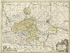
Episcopatvs Halberstadensis Descriptio nova
1 : 410000 Mollova mapová sbírka Zetter, Paul de Schenk, Peter I
Episcopatvs Halberstadensis Descriptio nova
1 : 410000 Mollova mapová sbírka Janssonius, Johannes Zetter, Paul de Janssonius, Johannes I
Straßen im Herzogtum Braunschweig 1848
Staat Braunschweig Straßennetz Kunz, Andreas ; Treiling, Thomas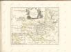
Das Herzogthum Braunschweig
1 : 548000 Braunschweig (Německo) Schlieben Gleditsch
MAGDEBVRGENSIS | ARCHIEPISCOPATVS.
Amstelædami | J. Blaeu excudebat.
Episcopatus Halberstadensis Descriptio nova. [Karte], in: Novus atlas absolutissimus, Bd. 2, S. 89.
1 Karte aus Atlas Janssonius Offizin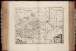
Episcopatvs Halberstadensis descriptio nova / Paullus de Zetter, fe
1 : 410000 Annotatie: Origineel is Blad 89 in atlas factice; Annotatie geografische gegevens: Schaalvermelding op kaart: 3 Milliaria Germanica communia; Nummering rechtsboven: XVIII Paullus de Zetter [Amstelodami : Ex Officina Janssonio-Waesbergiana, Mosis Pitt et Stephani Swart]
Carta Delli Dvcati di Brvnsvvic, e Lvnebvrg con le loro ad herenze Vescounti, Contee, e Dominy
1 : 370000 Mollova mapová sbírka Hacque, Johann Baptist Hacque, Johann Baptist

DUCATUS BRUNSVICENSIS FEREQUE LUNAEBURGENSIS
1 : 370000 Braunschweig (Německo) Visscher, Claes Jansz. C.I. Visscher excudit
Regierungsbezirk Magdeburg Kreiseinteilung 1820
Preußen, Magdeburg, Regierungsbezirk Kunz, Andreas ; Johnen, Bettina ; Moeschl, Joachim