Maps of gmina Lubniewice

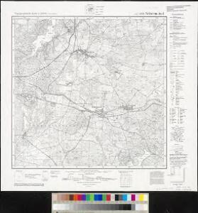
Meßtischblatt 3557 : Schermeisel, 1941
1 : 250000 Schermeisel. - Aufn. 1894, hrsg. 1896, bericht. 1934, letzte Nachtr. 1939, Ausg. 1941. - 1:25000. - [Berlin]: Reichsamt für Landesaufnahme, 1941. - 1 Kt.
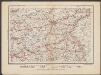
Composite: 297 Zielenzig.
1 : 100000 Reichsamt fur Landesaufnahme
297. Zielenzig.
1 : 100000 Reichsamt fur Landesaufnahme
297.1 Zielenzig.
1 : 100000 Reichsamt fur Landesaufnahme
91. Frankfurt a/O., uit: Topographische Uebersichtskarte des Deutschen Reiches / herausgegeben v. d. Kartogr. Abt. d. Königl. Preuß. Landesaufnahme
1 : 200000 titelvariant: Topogr. Übersichtskarte des Deutschen Reiches; Annotatie: Titel boven bladen ook: Topogr. Übersichtskarte des Deutschen Reiches; Annotatie geografische gegevens: Op elk blad twee maatstokken: 10 Kilometer = 5,5 cm; 1 geogr. Meile = 3,6 cm; Legenda onder op elk blad Königlich Preußische Landesaufnahme. Kartographische Abtheilung [S.l : Königlich Preußische Landesaufnahme, Kartographische Abtheilung]
Der Sternbergsche Creis
1 : 292000 Sotzmann, Daniel Friedrich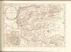

Frankfurt 61, uit: Special-Karte von Mittel-Europa / nach amtlichen Quellen bearbeitet von W. Liebenow
1 : 300000 titelvariant: W. Liebenow's Mittel-Europa; Annotatie: Titel boven de bladen: W. Liebenow's Mittel-Europa Johannes Wilhelm Liebenow 1822-1897 Frankfurt a. M. : Ludwig Ravenstein
Ducatus Silesiae Glogani Vera Delineatio [Karte], in: Novus Atlas, das ist, Weltbeschreibung, Bd. 1, S. 182.
1 Karte aus Atlas Blaeu, Joan Blaeu, Willem Janszoon
Marchia nova Vulgo New Marck in March: Brandenburg
1 : 470000 Mollova mapová sbírka Schenk, Pieter Schenk, Peter I
Ducatus Silesiae Glogani Ver Delineatio [Karte], in: Le théâtre du monde, ou, Nouvel atlas contenant les chartes et descriptions de tous les païs de la terre, Bd. 1, S. 213.
1 Karte aus Atlas Blaeu, Willem Janszoon und Blaeu, Joan Blaeu, Willem Janszoon
Ducatus Silesiae Glogani Vera Delineatio [Karte], in: Novus atlas absolutissimus, Bd. 2, S. 258.
1 Karte aus Atlas Janssonius Offizin
Die Lausitz nach astronomischen Ortsbestimmungen und den besten Hülfsmitteln
1 : 320000 Lužice (Německo) Fembo, Christoph Christoph Fembo
Sect. 15: Frankfurt a/O, uit: Geologische Karte des Deutschen Reichs in 27 Blaettern / [von] Richard Lepsius ; Red. von C. Vogel
1 : 500000 Annotatie: Blad 18 ontbreekt; Een aantal bladen op linnen; Een aantal bladen gereviseerd 1913-1914; Annotatie geografische gegevens: Met schaalstokken o.a. in kilometers; Legenda Carl Vogel 1828-1897 Gotha : Justus Perthes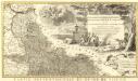
Novissimum Silesiae Theatrum
1 : 400800 Mollova mapová sbírka Condet, Johannes Covens, Johannes I
Sbírka map a diagramů použitých na mírových konferencích v Paříži v letech 1919 - 1920
Posen
1 : 600000 Opitz, Carl Solbrig
Wendisch
Deutschland Sorbisch

Lužice

Lužice

Lužica

Marchia Nova; Vulgò New Marck in March. Brandenburg. [Karte], in: Novus atlas absolutissimus, Bd. 2, S. 63.
1 Karte aus Atlas Janssonius Offizin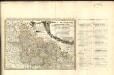
Dvcatvs Silesiae Tabvla Geographica Prima, Inferiorem eivs partem, seu novem principatvs, quorum insignia hic adjecta sunt, secundum statum recentissimum complectens =
1 : 575000 Mollova mapová sbírka Hase, Johann Matthias Homann, Johann Baptista - dědici
Palatinatus Posnaniensis. In Majori Polonia Primarii Nova Delinatio [Karte], in: Novus atlas absolutissimus, Bd. 1, S. 96.
1 Karte aus Atlas Janssonius Offizin
Electoratus sive Marchia Brandenburgensis, juxta novissimam Delineationem in mappa Geographica accuratae aeri incisa opera et Sumptibus
1 : 500000 Mollova mapová sbírka Seutter, Matthäus Seutter, Matthäus
Electoratus sive marchia Brandenburgensis juxta novissimam delineationem in mappa geographica, accurate aeri incisa
1 : 548000 Braniborsko (Německo) Seutter, Matthäus sumptibus Mathaei Seutteri
Electoratus sive marchia Brandenburgensis juxta novissimam delineationem in mappa geographica accurate aeri incisa
1 : 548000 Braniborsko (Německo) Seutter, Matthäus Mathaei Seutteri
Übersichts-Karte für den Marsch des Königs aus Sachsen nach Schlesien Anfangs May 1761