Maps of gmina Tarnowo Podgórne

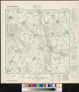
Meßtischblatt 3565 : Gr. Gay, 1940
1 : 250000 Gr. Gay. - Ausg. m. dt. Namen, letzte Nachtr. 1937. - 1:25000. - [Berlin]: Reichsamt für Landesaufnahme, 1940. - 1 Kt.
93. Posen, uit: Topographische Uebersichtskarte des Deutschen Reiches / herausgegeben v. d. Kartogr. Abt. d. Königl. Preuß. Landesaufnahme
1 : 200000 titelvariant: Topogr. Übersichtskarte des Deutschen Reiches; Annotatie: Titel boven bladen ook: Topogr. Übersichtskarte des Deutschen Reiches; Annotatie geografische gegevens: Op elk blad twee maatstokken: 10 Kilometer = 5,5 cm; 1 geogr. Meile = 3,6 cm; Legenda onder op elk blad Königlich Preußische Landesaufnahme. Kartographische Abtheilung [S.l : Königlich Preußische Landesaufnahme, Kartographische Abtheilung]
Posen 62, uit: Special-Karte von Mittel-Europa / nach amtlichen Quellen bearbeitet von W. Liebenow
1 : 300000 titelvariant: W. Liebenow's Mittel-Europa; Annotatie: Titel boven de bladen: W. Liebenow's Mittel-Europa Johannes Wilhelm Liebenow 1822-1897 Frankfurt a. M. : Ludwig Ravenstein

Ducatus Silesiae Glogani Vera Delineatio [Karte], in: Novus Atlas, das ist, Weltbeschreibung, Bd. 1, S. 182.
1 Karte aus Atlas Blaeu, Joan Blaeu, Willem Janszoon
Ducatus Silesiae Glogani Ver Delineatio [Karte], in: Le théâtre du monde, ou, Nouvel atlas contenant les chartes et descriptions de tous les païs de la terre, Bd. 1, S. 213.
1 Karte aus Atlas Blaeu, Willem Janszoon und Blaeu, Joan Blaeu, Willem Janszoon
Ducatus Silesiae Glogani Vera Delineatio [Karte], in: Novus atlas absolutissimus, Bd. 2, S. 258.
1 Karte aus Atlas Janssonius Offizin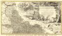
Novissimum Silesiae Theatrum
1 : 400800 Mollova mapová sbírka Condet, Johannes Covens, Johannes I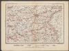
Posen
1 : 600000 Opitz, Carl Solbrig

Monumenta Cartographica Bohemiae II.: Müllerova mapa

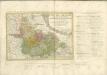
Provinz Posen
1 : 1200000 Provinz Posen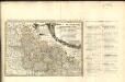
Dvcatvs Silesiae Tabvla Geographica Prima, Inferiorem eivs partem, seu novem principatvs, quorum insignia hic adjecta sunt, secundum statum recentissimum complectens =
1 : 575000 Mollova mapová sbírka Hase, Johann Matthias Homann, Johann Baptista - dědici
Posen.
1 : 810000 Radefeld, Carl Christian Franz, 1788-1874
Palatinatus Posnaniensis. In Majori Polonia Primarii Nova Delinatio [Karte], in: Novus atlas absolutissimus, Bd. 1, S. 96.
1 Karte aus Atlas Janssonius Offizin
Provinz Posen
Grosser Hand-Atlas über alle Theile der Erde in 170 Karten Meyer, J. Verlag des Bibliographischen Instituts
Übersichts-Karte für den Marsch des Königs aus Sachsen nach Schlesien Anfangs May 1761

Silesia Inferior. [Karte], in: Le théâtre du monde, ou, Nouvel atlas contenant les chartes et descriptions de tous les païs de la terre, Bd. 1, S. 210.
1 Karte aus Atlas Blaeu, Willem Janszoon und Blaeu, Joan Blaeu, Willem Janszoon
Übersichtskarte von Mittel - Europa

SILESIA | INFERIOR
Noviter et accurata delineata | á Jona Sculteto Sprotta Silesio. [Amsterdam : Joan Blaeu]
Kreise der Provinz Posen 1864
Preußen, Provinz Posen, Verwaltungsgliederung Kunz, Andreas ; Moeschl, Joachim Robert
PALATINATVS | POSNANIENSIS, | IN MAIORI POLONIA PRIMARII
NOVA DELINEATIO | Per G.F.M. Gerard Coeck sculpsit. Amsterdami | Exc. Joannes Blaeu.
Posen, Glogau, Schweidnitz, Oppeln, Kalisz
1 : 750000 Głogów (Polsko : oblast) Geng, K. K. u. k. Militärgeographisches Institut
Posen, Glogau, Schweidnitz, Oppeln, Kalisz
1 : 750000 Głogów (Polsko : oblast) K. k. militär-geographisches Institut
Silesia Inferior [Karte], in: Novus atlas absolutissimus, Bd. 2, S. 255.
1 Karte aus Atlas Janssonius Offizin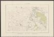
Silesia Inferior. [Karte], in: Theatrum orbis terrarum, sive, Atlas novus, Bd. 1, S. 144.
1 Karte aus Atlas Blaeu, Joan Blaeu, Willem Janszoon
Silesia Inferior. [Karte], in: Novus Atlas, das ist, Weltbeschreibung, Bd. 1, S. 179.
1 Karte aus Atlas Blaeu, Joan Blaeu, Willem Janszoon