Maps of Samtgemeinde Lindhorst

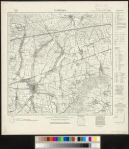
Meßtischblatt 1951 : Stadthagen, 1937
1 : 250000 Stadthagen. - Aufn. 1896, hrsg. 1898, ber. 1924, gedr. [19]37. - 1:25000. - [Berlin]: Reichsamt für Landesaufnahme, 1937. - 1 Kt.
Meßtischblatt 1951 : Stadthagen, 1898
1 : 250000 Stadthagen. - Aufn. 1896. - 1:25000. - [Berlin]: Reichsamt für Landesaufnahme, 1898. - 1 Kt.
285. Minden.
1 : 100000 Reichsamt fur Landesaufnahme
Composite: 285. Minden.
1 : 100000 Reichsamt fur Landesaufnahme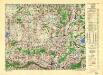
Germany/Central Europe 1:100,000, Minden
Germany / Central Europe 1:100,000, Series GSGS 4416. Great Britain. War Office. [London] : Ordnance Survey

Hannover 58, uit: [W. Liebenow's Special-Karte von Mittel-Europa]
1 : 300000 titelvariant: W. Liebenow's Mittel-Europa; Annotatie: Titel boven de bladen: W. Liebenow's Mittel-Europa Johannes Wilhelm Liebenow 1822-1897 Hannover : Hermann Oppermann
Hannover 58, uit: Special-Karte von Mittel-Europa / nach amtlichen Quellen bearbeitet von W. Liebenow
1 : 300000 titelvariant: W. Liebenow's Mittel-Europa; Annotatie: Titel boven de bladen: W. Liebenow's Mittel-Europa Johannes Wilhelm Liebenow 1822-1897 Frankfurt a. M. : Ludwig Ravenstein
Episcopatvs Hildesiensis descriptio novissima
1 : 320000 Mollova mapová sbírka Gigas, Johann Michael Schenk, Peter I
Episcopatvs Hildesiensis descriptio novissima
1 : 320000 Mollova mapová sbírka Gigas, Johann Michael Janssonius, Johannes I
Episcopatvs Hildesiensis descriptio novissima
1 : 440000 Mollova mapová sbírka Merian, Matthaeus Merian, Matthäus - dědici
EPISCOPATVS | HILDESIENSIS | DESCRIPTIO NOVISSIMA
Authore Ioanne Gigante D. Med. et Math. [Amsterdam : Joan Blaeu]
Übersicht der Operationen der Allirten u. Französischen Armee im November 1761, vom Uebergange des Herzogs über die Weser bis zu Ende des Feldzuges
1 : 200000
Episcopatus Hildesiensis Descriptio Novissima [Karte], in: Gerardi Mercatoris et I. Hondii Newer Atlas, oder, Grosses Weltbuch, Bd. 1, S. 286.
1 Karte aus Atlas Mercator, Gerhard und Hondius, Jodocus Jansson, Jan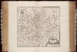
Episcopatvs Hildesiensis descriptio novissima / authore Ioanne Gigante
1 : 310000 Annotatie: Origineel is Blad 86 in atlas factice; Annotatie geografische gegevens: Met drie schaalstokken: 3 Milliaria Saxonica magna quorum decem constituunt gradum coelestem, en: 3 Milliaria Saxonica mediocria, en: 6 Horae itineris pedestris; Rechtsboven: XVII Johannes Janssonius van Waesberge -1681?; Moses Pitt ca. 1654-1696; Stephanus Swart [Amstelodami : apud Janssonio-Waesbergios, Mosem Pitt et Stephanu Swart]
Episcopatus Hildesiensis Descriptio Novissima [Karte], in: Novus atlas absolutissimus, Bd. 2, S. 84.
1 Karte aus Atlas Janssonius Offizin

Episcopatus Hildesiensis nec non Vicinorum Statuum delineatio Geographica
1 : 290000 Mollova mapová sbírka Arenhold, Gerard J. Schneider, Ruprecht Adam Homann, Johann Baptista - dědici
Episcopatus Hildesiensis Descriptio Novissima [Karte], in: Novus Atlas, das ist, Weltbeschreibung, Bd. 1, S. 108.
1 Karte aus Atlas Blaeu, Joan Blaeu, Willem Janszoon
Episcopatus Hildesiensis Descriptio Novissima [Karte], in: Theatrum orbis terrarum, sive, Atlas novus, Bd. 1, S. 194.
1 Karte aus Atlas Blaeu, Joan Blaeu, Willem Janszoon
Le Theatre de Bellone :
Mollova mapová sbírka Schenk, Pieter Braakman, Adriaan
Episcopatus Hildesiensis Descriptio Novissima [Karte], in: Le théâtre du monde, ou, Nouvel atlas contenant les chartes et descriptions de tous les païs de la terre, Bd. 1, S. 137.
1 Karte aus Atlas Blaeu, Willem Janszoon und Blaeu, Joan Blaeu, Willem Janszoon
Episcopatus Hildesiensis cum adjacentibus provinciis ac statibus mappa geographica repraesentatus
1 : 290000 Hildesheim (Německo) Seutter, Matthäus studio et impensis Matthaei Seutteri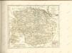

Carta Delli Dvcati di Brvnsvvic, e Lvnebvrg con le loro ad herenze Vescounti, Contee, e Dominy
1 : 370000 Mollova mapová sbírka Hacque, Johann Baptist Hacque, Johann Baptist
DUCATUS BRUNSVICENSIS FEREQUE LUNAEBURGENSIS
1 : 370000 Braunschweig (Německo) Visscher, Claes Jansz. C.I. Visscher excudit
Ducatus Luneburgici et comitatus Dannenbergensis
1 : 363000 Lüneburg (Německo) Visscher, Nicolaus Schenk, Pieter Pet. Schenk Iun.
Die Fürstenthümer Grubenhagen, Calenberg, Wolfenbütel und Blankenburg, welche den südlichen Theil der chur- und fürstl. braunschweig-lüneburgi[schen] Reichsländer begreifen
1 Karte : Kupferdruck ; 46 x 57 cm Güssefeld bey denen Homænnischen Erben