Maps of Spreenhagen

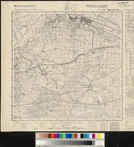
Meßtischblatt 3649 : Spreenhagen, 1941
1 : 250000 Spreenhagen. - Aufn. 1901, hrsg. 1903, bericht. 1920, letzte Nachtr. 1940, [Ausg. 1941]. - 1:25000. - [Berlin]: Reichsamt für Landesaufnahme, 1941. - 1 Kt.
Meßtischblatt 1979 : Spreenhagen, 1906
1 : 250000 Spreenhagen. - Aufn. 1901, hrsg. 1903, einz. Nachtr. 1906. - 1:25000. - [Berlin]: Königl. Preuss. Landesaufnahme, 1906. - 1 Kt.
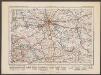
Composite: 295. Furstenwalde.
1 : 100000 Reichsamt fur Landesaufnahme
295. Furstenwalde.
1 : 100000 Reichsamt fur Landesaufnahme
Blatt XII Fürstenwalde, uit: Karte von Berlin und Umgebung in 12 Blättern
1 : 50000 Annotatie: Toelichtingen opgeborgen bij kaart; Annotatie geografische gegevens: Met schaalstokken: Meter, Schritt, geographische Meile Paul Schneider Berlin : Reichsamt für Landesaufnahme
90. Berlin (Süd), uit: Topographische Uebersichtskarte des Deutschen Reiches / herausgegeben v. d. Kartogr. Abt. d. Königl. Preuß. Landesaufnahme
1 : 200000 titelvariant: Topogr. Übersichtskarte des Deutschen Reiches; Annotatie: Titel boven bladen ook: Topogr. Übersichtskarte des Deutschen Reiches; Annotatie geografische gegevens: Op elk blad twee maatstokken: 10 Kilometer = 5,5 cm; 1 geogr. Meile = 3,6 cm; Legenda onder op elk blad Königlich Preußische Landesaufnahme. Kartographische Abtheilung [S.l : Königlich Preußische Landesaufnahme, Kartographische Abtheilung]
Der Lebusische Creis
1 : 296000 Lubušsko (Německo a Polsko) Oesfeld, Karl Ludwig von Sotzmann, Daniel Friedrich
Der Lebusische Creis
1 : 296000 Lubušsko (Německo a Polsko) Oesfeld, Karl Ludwig von Sotzmann, Daniel Friedrich
Der Lebusische Creis
1 : 296000 Lubušsko (Německo a Polsko) Oesfeld, Karl Ludwig von Sotzmann, Daniel Friedrich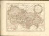

Topographische Carte : Hundert Quadrat-Meilen um Berlin
1 : 184000
Frankfurt 61, uit: Special-Karte von Mittel-Europa / nach amtlichen Quellen bearbeitet von W. Liebenow
1 : 300000 titelvariant: W. Liebenow's Mittel-Europa; Annotatie: Titel boven de bladen: W. Liebenow's Mittel-Europa Johannes Wilhelm Liebenow 1822-1897 Frankfurt a. M. : Ludwig Ravenstein
Marchionatus Lusatiae inferioris Bohemiae olim regno jam elect. Saxoniae subject in circulos, dynastias et praefect. accuratissime distinctus
1 : 180000 Horní Lužice (Německo) Seutter, Matthäus Lotter, Tobias Conrad sumtibus Matth. Seutteri
Lusatiae inferioris tabula chorographica secundum statum recentissimum
1 : 290000 Dolní Lužice (Německo) Homannianos Heredes
Lusatiae inferioris tabula chorographica
1 : 290000 Dolní Lužice (Německo) Hübner, Johann Homann, Johann Baptist curis Homannianorum Heredum
MARCH. BRANDENBURGICI | PARS, quæ | MARCHIA MEDIA | Vulgo MITTELMARCK audit.
Amstelædami, | Excud. Joannes Blaeu.
[Berlin und Umgebung; Die Donau von Paussau bis Wien mit Umgebung]
Stieler's Hand-Atlas Stieler, Adolf bei Justus Perthes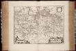
March. Brandenburgici pars, quae Marchia Media vulgo Mittelmarck audit
1 : 400000 Annotatie: Origineel is Blad 91 in atlas factice; Annotatie geografische gegevens: Met schaalstok: Milliaria Germanica Joan Blaeu 1597/98-1673 Amstelaedami : excud. Joannes Blaeu
Die Lausitz nach astronomischen Ortsbestimmungen und den besten Hülfsmitteln
1 : 320000 Lužice (Německo) Fembo, Christoph Christoph Fembo
Lužica

Sect. 15: Frankfurt a/O, uit: Geologische Karte des Deutschen Reichs in 27 Blaettern / [von] Richard Lepsius ; Red. von C. Vogel
1 : 500000 Annotatie: Blad 18 ontbreekt; Een aantal bladen op linnen; Een aantal bladen gereviseerd 1913-1914; Annotatie geografische gegevens: Met schaalstokken o.a. in kilometers; Legenda Carl Vogel 1828-1897 Gotha : Justus Perthes
Marchia Media Vulgo Mittel Marck in March: Brandenb:
1 : 500000 Mollova mapová sbírka Valk, Gerhard Schenk, Peter I
Marchia Media Vulgo Mittel Marck in March: Brandenb:
1 : 510000 Mollova mapová sbírka Janssonius, Johannes Janssonius, Johannes I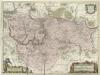
March. Brandenburgici Pars, quae Marchia Media Vulgo Mittesmarck audit
1 : 400000 Mollova mapová sbírka Wit, Frederik de Covens, Johannes I
Sbírka map a diagramů použitých na mírových konferencích v Paříži v letech 1919 - 1920
Berlin
1 : 600000 Opitz, Carl Solbrig
Wendisch
Deutschland Sorbisch
Marchia Media; Vulgo Mittel Marck in March: Brandenb: [Karte], in: Novus atlas absolutissimus, Bd. 2, S. 60.
1 Karte aus Atlas Janssonius Offizin
Lužice