Maps of Grodzisk Wielkopolski

Meßtischblatt 3764 : Grätz (Wartheld), 1941
1 : 250000 Grätz (Wartheld.). - Aufn. 1890, hrsg. 1892, bericht. 1941. - 1:25000. - [Berlin]: Reichsamt für Landesaufnahme, 1941. - 1 Kt.
Composite: 324. Kosten.
1 : 100000 Reichsamt fur Landesaufnahme
93. Posen, uit: Topographische Uebersichtskarte des Deutschen Reiches / herausgegeben v. d. Kartogr. Abt. d. Königl. Preuß. Landesaufnahme
1 : 200000 titelvariant: Topogr. Übersichtskarte des Deutschen Reiches; Annotatie: Titel boven bladen ook: Topogr. Übersichtskarte des Deutschen Reiches; Annotatie geografische gegevens: Op elk blad twee maatstokken: 10 Kilometer = 5,5 cm; 1 geogr. Meile = 3,6 cm; Legenda onder op elk blad Königlich Preußische Landesaufnahme. Kartographische Abtheilung [S.l : Königlich Preußische Landesaufnahme, Kartographische Abtheilung]

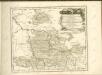
Posen 62, uit: Special-Karte von Mittel-Europa / nach amtlichen Quellen bearbeitet von W. Liebenow
1 : 300000 titelvariant: W. Liebenow's Mittel-Europa; Annotatie: Titel boven de bladen: W. Liebenow's Mittel-Europa Johannes Wilhelm Liebenow 1822-1897 Frankfurt a. M. : Ludwig Ravenstein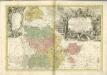

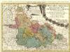
Ducatus Silesiae Glogani


DVCATVS | SILESIÆ | GLOGANI
Vera Delineatio | Secunda curâ ac labore confecta | A Iona Sculteta Sprotta Silesio. [Amsterdam : Joan Blaeu]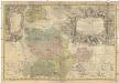
PRINCIPATVS SILESIAE GLOGOVIENSIS novissima Tabula Geographica
1 : 203000 Głogów (Polsko) Wieland, Johann Wolfgang Schubarth, Matthaeus ab Haeredibus Homannianis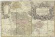
Principatvs Silesiae Glogoviensis novissima tabula geographica sistens 6 ejusdem circulos Glogav, Freystadt, Gvhrav, Sprottav, Grünberg et Schwiebvs, cum districtu Polckwitz nec non liberam dynastiam Bevthen et Carolath
1 : 208000 Głogów (Polsko) Wieland, Johann Wolfgang Schubarth, Matthäus Homannianos Heredes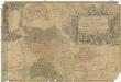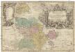
Principatvs Silesiae Glogoviensis novissima tabula geographica sistens VI. ejusdem circulos Glogav, Freystadt, Gvhrav, Sprottav, Grvnberg et Schwiebvs, cum districtu Polckwitz nec non liberam dynastiam Bevthen et Carolath
1 : 200000 Głogów (Polsko) Wieland, Johann Wolfgang Schubarth, Matthäus ab Haeredibus Homannianis
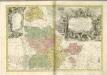
Ducatus Silesiae Glogani vera Delineatio [Karte], in: Gerardi Mercatoris et I. Hondii Newer Atlas, oder, Grosses Weltbuch, Bd. 1, S. 316.
1 Karte aus Atlas Mercator, Gerhard und Hondius, Jodocus Jansson, Jan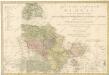
Das Fürstenthum Glogau in seine sechs landrathlichen Kreise
Ducatus Silesiae Glogani Vera Delineatio [Karte], in: Theatrum orbis terrarum, sive, Atlas novus, Bd. 1, S. 147.
1 Karte aus Atlas Blaeu, Joan Blaeu, Willem Janszoon
Ducatus Silesiae Glogani Vera Delineatio [Karte], in: Novus Atlas, das ist, Weltbeschreibung, Bd. 1, S. 182.
1 Karte aus Atlas Blaeu, Joan Blaeu, Willem Janszoon
Ducatus Silesiae Glogani Ver Delineatio [Karte], in: Le théâtre du monde, ou, Nouvel atlas contenant les chartes et descriptions de tous les païs de la terre, Bd. 1, S. 213.
1 Karte aus Atlas Blaeu, Willem Janszoon und Blaeu, Joan Blaeu, Willem Janszoon
Ducatus Silesiae Glogani Vera Delineatio [Karte], in: Novus atlas absolutissimus, Bd. 2, S. 258.
1 Karte aus Atlas Janssonius Offizin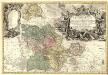
Principatvs Silesiae Glogoviensis novissima Tabula Geographica sistens VI. ejusdem Circulos Glogav, Freystadt, Gvhrav, Sprottav, Grünberg et Schwiebvs, cum districtu Polckwitz nec non Liberam Dynastiam Bevthen et Carolath.
1 : 208000 Mollova mapová sbírka Wieland, Johann Wolfgang Homann, Johann Baptista - dědici
Sect. 15: Frankfurt a/O, uit: Geologische Karte des Deutschen Reichs in 27 Blaettern / [von] Richard Lepsius ; Red. von C. Vogel
1 : 500000 Annotatie: Blad 18 ontbreekt; Een aantal bladen op linnen; Een aantal bladen gereviseerd 1913-1914; Annotatie geografische gegevens: Met schaalstokken o.a. in kilometers; Legenda Carl Vogel 1828-1897 Gotha : Justus Perthes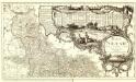
Basse Silesie Raduitte en deux Feuilles sur celle de 16 Faittes sur les lieux
1 : 408000 Mollova mapová sbírka Le Rouge, Georges-Louis Schubarth, Matthäus
Silesia Inferior
1 : 870000 Mollova mapová sbírka Scultetus, Johannes Schenk, Peter I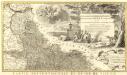
Novissimum Silesiae Theatrum
1 : 400800 Mollova mapová sbírka Condet, Johannes Covens, Johannes I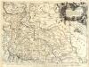
Parte inferiore del Ducato di Silesia
1 : 525000 Mollova mapová sbírka Cantelli, Giacomo De Rossi, Domenico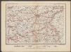
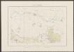
Posen
1 : 600000 Opitz, Carl Solbrig