Maps of Völpke

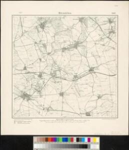
Meßtischblatt 2097, neue Nr. 3832 : Hötensleben, 1934
1 : 250000 Hötensleben. - Hrsg. 1902, bericht. 1927, letzte Nachtr. 1934. - 1:25000. - [Berlin]: Reichsamt für Landesaufnahme, 1934. - 1 Kt.
Meßtischblatt 2097 : Hötensleben, 1902
1 : 250000 Hötensleben. - Aufn. 1900. - 1:25000. - [Berlin]: Reichsamt für Landesaufnahme, 1902. - 1 Kt.
87. Braunschweig, uit: Topographische Uebersichtskarte des Deutschen Reiches / herausgegeben v. d. Kartogr. Abt. d. Königl. Preuß. Landesaufnahme
1 : 200000 titelvariant: Topogr. Übersichtskarte des Deutschen Reiches; Annotatie: Titel boven bladen ook: Topogr. Übersichtskarte des Deutschen Reiches; Annotatie geografische gegevens: Op elk blad twee maatstokken: 10 Kilometer = 5,5 cm; 1 geogr. Meile = 3,6 cm; Legenda onder op elk blad Königlich Preußische Landesaufnahme. Kartographische Abtheilung [S.l : Königlich Preußische Landesaufnahme, Kartographische Abtheilung]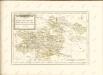

Magdeburg 59, uit: Special-Karte von Mittel-Europa / nach amtlichen Quellen bearbeitet von W. Liebenow
1 : 300000 titelvariant: W. Liebenow's Mittel-Europa; Annotatie: Titel boven de bladen: W. Liebenow's Mittel-Europa Johannes Wilhelm Liebenow 1822-1897 Frankfurt a. M. : Ludwig Ravenstein
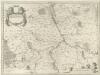
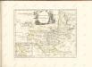
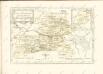
Principatvs Anhaltinvs
1 : 260000 Mollova mapová sbírka Blaeu, Joan Blaeu, Joan I.
Carté de la Principauté de Halberstadt
1 : 170000 Mollova mapová sbírka Riese, G. Hieronymus Homann, Johann Baptista - dědici
PRINCIPATVS | ANHALTINVS.
[Amsterdam : Joan Blaeu]
Anhaltinus Principatus Stirpis Ascaniensis felicitate hodiè florens
Seutter, Matthäus; Lotter, Tobias Conrad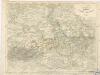
Die Herzogthümer Anhalt, Dessau, Cöthen u. Bernburg

Straßen in den Anhaltischen Herzogtümern 1848
Anhalt Straßennetz Kunz, Andreas ; Treiling, Thomas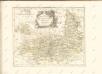

Die Herzogthümer Anhalt Dessau, Cöthen u. Bernburg
1 : 780000 Anhaltsko (Německo) Bibliographisches Institut
EPISCOPATVS | HALBERSTAT.
Amstlædami apud Joannem Blaeu.
Magdebvrgensis Archiepiscopatvs
1 : 350000 Mollova mapová sbírka Blaeu, Joan Blaeu, Joan I.
Episcopatus Hildesiensis nec non vicinorum statuum delineatio geographica
1 : 287000 Hildesheim (Německo) Arenhold, Gerhard Justus Haered. Ioh. Baptist. Homanni
Episcopatus Hildesiensis nec non vicinorum statuum delineatio geographica
1 : 287000 Hildesheim (Německo) Arenhold, Gerhard Justus Haered. Ioh. Baptist. Homanni
Episcopatus Hildesiensis cum adjacentibus provinciis ac statibus mappa geographica repraesentatus
1 : 290000 Hildesheim (Německo) Seutter, Matthäus studio et impensis Matthaei Seutteri
Charte von dem Herzogthume Braunschweig
1 : 267500 Braunschweig (Německo : historické území) Streit, Friedrich Wilhelm Beyer, I. Friedrich Campe
Braunschweig Herzogthum.
1 : 425000 Gotthard, A.
Geographische Charte des Herzogthums Magdenburg und Halle
1 : 308000 Halle an der Saale-oblast (Německo) Schenk, Pieter P. Schenk
Geographische Charte des Herzogthums Magdenburg und Halle
1 : 308000 Halle an der Saale-oblast (Německo) Schenk, Pieter P. Schenk
Geographische Charte des Herzogthums Magdenburg und Halle
1 : 308000 Halle an der Saale-oblast (Německo) Schenk, Pieter P. Schenk
Episcopatvs Halberstadensis Descriptio nova
1 : 410000 Mollova mapová sbírka Funck, David Zetter, Paul de Funck, David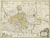
Episcopatvs Halberstadensis Descriptio nova
1 : 410000 Mollova mapová sbírka Zetter, Paul de Schenk, Peter I
Episcopatvs Halberstadensis Descriptio nova
1 : 410000 Mollova mapová sbírka Janssonius, Johannes Zetter, Paul de Janssonius, Johannes I
Straßen im Herzogtum Braunschweig 1848
Staat Braunschweig Straßennetz Kunz, Andreas ; Treiling, Thomas