Maps of Emmerthal

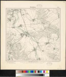
Meßtischblatt 2154 : Kirchohsen, 1934
1 : 250000 Kirchohsen. - Aufn. 1896, Nachtr. 1926, gedr. [19]34. - 1:25000. - [Berlin]: Reichsamt für Landesaufnahme, 1934. - 1 Kt.
Meßtischblatt 2154 : Kirchohsen, 1898
1 : 250000 Kirchohsen. - Aufn. 1896. - 1:25000. - [Berlin]: Reichsamt für Landesaufnahme, 1898. - 1 Kt.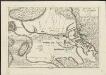
Bataille de Hastenbeck près de Hanover du 26. Juillet 1757
1 : 24000 A Paris : chez le Sr. Le Rouge, Rue des Grands Augustins
Plan de la Bataille d'Hastenbeck
1 : 20000 Mollova mapová sbírka Trattner, Johann Thomas Trattner, Johann Thomas von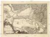
Schlacht bey Hastenbeck, im Hanoevrischen, welche den 26. Julius 1757, von dem Marschall von Etrées, General der franzoesischen Armée, gegen die Hanoevrische, unter Anführung des Hertzogs von Cumberland, gewonnen worden.
1 : 30000 Hastenbeck (Hameln, Německo) Pinkawa, Leopold Benno Bayer, Hieronymus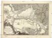
Bataille de Hastenbeck, dans le pays de Hanovre, gagnée par le maréchal d'Etrées, commandant les troupes françoises, sur celles des Hanovriens, aux ordre du duc de Cumberland, le 26 juillet, 1757.
1 : 30000 Hastenbeck (Hameln, Německo) Pinkawa, Leopold Benno Bayer, Hieronymus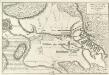
Bataille de Hastenbeck près de Hanover du 26. Juillet 1757
Mollova mapová sbírka Le Rouge, Georges-Louis Le Rouge, Georges-Louis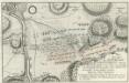
Plan der Bataille beÿ Hastenbeck ohnweit Hameln
1 : 30000 Mollova mapová sbírka
Plan de la Bataille de Hastenbeck près de Hamelen
1 : 40000 Mollova mapová sbírka Oebschelwitz, L. W. von Hondt, Pierre de
Plan de la bataille écheuë entre l'armée françoise commandée par mr. le marechal d'Etrées et l'armée des alliés de Hanovre commandée par mr. le duc de Cumberland en faveur de l'armée françoise
Hastenbeck (Hameln, Německo) Seutter, Albrecht Carl von Albrecht Carl Seutter
Plan de Hameln
1 : 2400 Mollova mapová sbírka Le Rouge, Georges-Louis Le Rouge, Georges-Louis
Die Grafschaft Pyrmont
1 : 50000 Mollova mapová sbírka Overheide, J. A. Homann, Johann Baptista - dědici
Plan de la bataille écheûë entre l'armée Françoise Commandée par Mr. le Marechal D'Entrées Et l'Armée Des Alliés de Hanovre commandée par Mr. Le Duc de Cumberland en faveur de l'armée Françoise Donnée au jour
1 : 40000 Mollova mapová sbírka Seutter, Albrecht Carl Seutter, Albrecht Carl
Composite: 310. Hameln.
1 : 100000 Reichsamt fur Landesaufnahme
Topographish-petrographische Karte des Fürstenthums Pyrmont und dessen Umgegend
1 : 70000 Dolní Sasko (Německo) Curtze, G. Kirchner, W. Georg Uslar
310. Hameln.
1 : 100000 Reichsamt fur Landesaufnahme
Descriptio Comitatus Lippiensis.
Mollova mapová sbírka Hoffmann, Jakob
86. Hannover, uit: Topographische Uebersichtskarte des Deutschen Reiches / herausgegeben v. d. Kartogr. Abt. d. Königl. Preuß. Landesaufnahme
1 : 200000 titelvariant: Topogr. Übersichtskarte des Deutschen Reiches; Annotatie: Titel boven bladen ook: Topogr. Übersichtskarte des Deutschen Reiches; Annotatie geografische gegevens: Op elk blad twee maatstokken: 10 Kilometer = 5,5 cm; 1 geogr. Meile = 3,6 cm; Legenda onder op elk blad Königlich Preußische Landesaufnahme. Kartographische Abtheilung [S.l : Königlich Preußische Landesaufnahme, Kartographische Abtheilung]
Die umliegenden Gegenden um Minden, und die Schlacht bey Gofeld vom 1sten des Augustmonats, 1759
Minden (Německo) Trattner, Johann Thomas
Episcopatvs Paderborn nec non Abbatiae Corvei Territorium seculare
1 : 190000 Mollova mapová sbírka Gigas, Johann Michael Homann, Johann Baptista - dědici

Hannover 58, uit: [W. Liebenow's Special-Karte von Mittel-Europa]
1 : 300000 titelvariant: W. Liebenow's Mittel-Europa; Annotatie: Titel boven de bladen: W. Liebenow's Mittel-Europa Johannes Wilhelm Liebenow 1822-1897 Hannover : Hermann Oppermann
Hannover 58, uit: Special-Karte von Mittel-Europa / nach amtlichen Quellen bearbeitet von W. Liebenow
1 : 300000 titelvariant: W. Liebenow's Mittel-Europa; Annotatie: Titel boven de bladen: W. Liebenow's Mittel-Europa Johannes Wilhelm Liebenow 1822-1897 Frankfurt a. M. : Ludwig Ravenstein
Episcopatvs Hildesiensis descriptio novissima
1 : 317000 Hildesheim (Německo) Gigas, Johann Michael Ioanne Gigante
Episcopatvs Hildesiensis descriptio novissima
1 : 320000 Mollova mapová sbírka Gigas, Johann Michael Schenk, Peter I
Episcopatvs Hildesiensis descriptio novissima
1 : 320000 Mollova mapová sbírka Gigas, Johann Michael Janssonius, Johannes I
Episcopatvs Hildesiensis descriptio novissima
1 : 440000 Mollova mapová sbírka Merian, Matthaeus Merian, Matthäus - dědici
EPISCOPATVS | HILDESIENSIS | DESCRIPTIO NOVISSIMA
Authore Ioanne Gigante D. Med. et Math. [Amsterdam : Joan Blaeu]