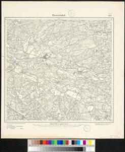
Maps of Harsewinkel

Meßtischblatt 2217 : Harsewinkel, 1897
1 : 250000 Harsewinkel. - Aufn. 1895. - 1:25000. - [Berlin]: Reichsamt für Landesaufnahme, 1897. - 1 Kt.
331. Warendorf.
1 : 100000 Reichsamt fur Landesaufnahme
Composite: 331. Warendorf.
1 : 100000 Reichsamt fur Landesaufnahme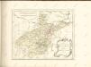

97. Münster i/Wf., uit: Topographische Uebersichtskarte des Deutschen Reiches / herausgegeben v. d. Kartogr. Abt. d. Königl. Preuß. Landesaufnahme
1 : 200000 titelvariant: Topogr. Übersichtskarte des Deutschen Reiches; Annotatie: Titel boven bladen ook: Topogr. Übersichtskarte des Deutschen Reiches; Annotatie geografische gegevens: Op elk blad twee maatstokken: 10 Kilometer = 5,5 cm; 1 geogr. Meile = 3,6 cm; Legenda onder op elk blad Königlich Preußische Landesaufnahme. Kartographische Abtheilung [S.l : Königlich Preußische Landesaufnahme, Kartographische Abtheilung]
307. Iburg.
1 : 100000 Reichsamt fur Landesaufnahme
Paderbornensis episcopatus descripto nova
1 : 222000 Paderborn-oblast (Německo) Gigas, Johann Michael Blaeu, Willem Janszoon Guilielmus Blaeuw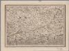
[16], uit: Hydro-Oro und Chorographische General Karte des Koenigreichs der Niederlande und der angrenzenden Länder bis Paris : mit der Angabe der Kunst und Heer-Strassen und der Entfernung der Poststationen / ... zusammengetragen und reducirt von ... Wilhelm Müller
1 : 400000 titelvariant: Generalkarte des Koenigreichs Hannover; Annotatie: 1e supplement bij: Generalkarte des Koenigreichs Hannover (1818) Müller, Wilhelm (fl. 1818) [Hannover : Wilhelm Müller]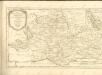

Episcopatvs Monasteriensis Pars Avstralis
1 : 290000 Mollova mapová sbírka Gigas, Johann Michael
Episcopatvs Monasteriensis Pars Avstralis
1 : 290000 Mollova mapová sbírka Gigas, Johann Michael
Tetrarchia Ducatus Geldriae Neomagensis
1 : 150000 Mollova mapová sbírka Wit, Frederik de Covens, Johannes I
Haute Partie De L'Evesché De Munster subdivisé en ses principales Iuridictions. [Karte], in: Atlas nouveau, contenant toutes les parties du monde [...], Bd. 1, S. 303.
1 Karte aus Atlas Sanson, Nicolas Jaillot, Alexis Hubert und Mortier, Pieter
Haute Partie de l'Evesché de Munster subdivisé en ses principales Iuridictios
1 : 300000 Mollova mapová sbírka Sanson, Guillaume Jaillot, Alexis Hubert
Monasteriensis et Osnabvrgensis Episcopatvs
1 : 490000 Mollova mapová sbírka Maschop, Gottfried
Rev.mo et Seren.mo Principi ac Domo. Dn. Ferdinando Archiep. et Elect. Colon. Episcop. Monasteriens Leto, Duci Bavariae
Mollova mapová sbírka Gigas, Johann Michael
Monasteriensis Episcopatvs
1 : 470000 Mollova mapová sbírka Schenk, Pieter Schenk, Peter I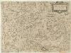
Carta del Vescovato di Mvnster
1 : 450000 Mollova mapová sbírka Hacque, Johann Baptist
Monasteriensis Episcopatus
1 : 460000 Mollova mapová sbírka Hondius, Jodocus Hondius, Jodocus
Monasteriensis Episcopatvs
1 : 460000 Mollova mapová sbírka Gigas, Johann Michael Blaeu, Joan I.
Monasteriensis Episcopatus
1 : 460000 Mollova mapová sbírka Gigas, Johann Michael Blaeu, Willem Jansz.
Generalkarte von Zentraleuropa
Übersichts Karte der Operationen von der Schlacht bei Vellinghausen bis zum Übergange des Marschalls Broglio über die Weser, vom 16ten Juli bis 21ten August 1761

Monasteriensis et Osnabvrgensis episcopatvs descriptio
1 Karte : Kupferdruck ; 36 x 25 cm Mascop; Ortelius s.n.
Monasteriensis et Osnabvrgensis episcopatvs descriptio
1 Karte : Kupferdruck ; 25 x 36 cm Mascop; Ortelius s.n.
MONASTERIENSIS | Episcopatus
Judocus Hondius excudit.
Carta del vescovato di Mvnster
1 : 480000 Münster in Westfalen-oblast (Německo) Bouttats, Gerhaert Hacque, Johann Baptist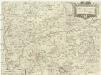
Carta del vescovato di Mvnster
1 : 480000 Münster in Westfalen-oblast (Německo) Bouttats, Gerhaert Hacque, Johann Baptist
Monasteriensis episcopatvs
1 : 485000 Münster in Westfalen-oblast (Německo) Janssonius, Johannes apud Ioannem Ianßonium