Maps of Dennewitz

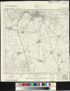
Meßtischblatt 4044 : Jüterbog, 1940
1 : 250000 Jüterbog. - Aufn. 1902, hrsg. 1903, bericht. 1927, letzte Nachtr. 1939, Ausg. 1940. - 1:25000. - [Berlin]: Reichsamt für Landesaufnahme, 1940. - 1 Kt.
Meßtischblatt 2246 : Jüterbog, 1933
1 : 250000 Jüterbog. - Hrsg. 1903, bericht. 1927, einz. Nachtr. 1933. - 1:25000. - [Berlin]: Reichsamt für Landesaufnahme, 1933. - 1 Kt.
Meßtischblatt 2246 : Jüterbog, 1927
1 : 250000 Jüterbog. - Aufn. 1902, bericht. 1927. - 1:25000. - [Berlin]: Reichsamt für Landesaufnahme, 1927. - 1 Kt.
Meßtischblatt 2246 : Jüterbog, 1903
1 : 250000 Jüterbog. - Aufn. 1902. - 1:25000. - [Berlin]: Reichsamt für Landesaufnahme, 1903. - 1 Kt.
Meßtischblatt 201 : Jüterbogk, 1874
1 : 250000 Jüterbogk. - Aufn. 1851. - 1:25000. - [Berlin]: Reichsamt für Landesaufnahme, 1874. - 1 Kt.
Schlacht bei Dennewitz den 6 ten September 1813
1 : 28800 Braniborsko (Německo) Mare, Carl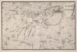
Schlacht bei Dennewitz Den 6ten September 1813
1 : 30000 Rau, Karl Ferdinand von; Maré, Carl Hampe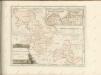

102. Wittenberg, uit: Topographische Uebersichtskarte des Deutschen Reiches / herausgegeben v. d. Kartogr. Abt. d. Königl. Preuß. Landesaufnahme
1 : 200000 titelvariant: Topogr. Übersichtskarte des Deutschen Reiches; Annotatie: Titel boven bladen ook: Topogr. Übersichtskarte des Deutschen Reiches; Annotatie geografische gegevens: Op elk blad twee maatstokken: 10 Kilometer = 5,5 cm; 1 geogr. Meile = 3,6 cm; Legenda onder op elk blad Königlich Preußische Landesaufnahme. Kartographische Abtheilung [S.l : Königlich Preußische Landesaufnahme, Kartographische Abtheilung]
Praefecturae principatus querfurtensis Dahmiana et Iüterboccensis cum vicinia oppidis, vicis, pagis accurate distincta
1 : 130000 Braniborsko (Německo) Seutter, Matthäus Lotter, Tobias Conrad M. Seutter
Carte Geographique, ou on fait voir le Dvche de Saxonie nome. le Cercle Electorale :
1 : 110000 Mollova mapová sbírka Homann, Johann Baptist Homann, Johann Baptista - dědici
Karte der Berlin-Anhaltischen Eisenbahn
1 : 200000 Verlag von Simon Schropp & Cop.
Accurate Geographische Delineation Derer Zum Fürstenthum Querfurth gehörigen zwey Aemmter Dahme und Jüterbog
1 : 120000 Mollova mapová sbírka Schenk, Pieter Schenk, Peter II
Praefecturae Principatus Querfurtensis Dahmiana Et Iüterboccensis
1 : 120000 Mollova mapová sbírka Lotter, Tobias Conrad Seutter, Matthäus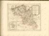

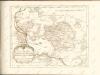
Marchionatus Brandenburgici Pars quae Marchia Vetus Vulgo Altemarck dicitur
1 : 290000 Mollova mapová sbírka Covens, Johannes Covens, Johannes I
Marchia Vetus, Vulgo Alte Marck in March: Brandenburgico
1 : 410000 Mollova mapová sbírka Janssonius, Johannes Janssonius, Johannes I
Marchia Vetus, Vulgo Alte Marck in March: Brandenburgico
1 : 410000 Mollova mapová sbírka Schenk, Pieter Schenk, Peter I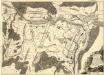
Exacter und accurater Plan der Manoeuvres, so dans König. Preuss. Corps, währender Zeit, dass selbiges zwischen der Stadt Spandau, und dem Dorfe Gatow campiret, täglich vorgenommen
1 : 15000 Mollova mapová sbírka Schleuen, Johann David Voss, Christian Friedrich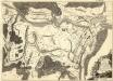
Exacter und accurater Plan der Manoeuvres, so dans König. Preuss. Corps, währender Zeit, dass selbiges zwischen der Stadt Spandau, und dem Dorfe Gatow campiret, täglich vorgenommen
1 : 15000 Mollova mapová sbírka Schleuen, Johann David Voss, Christian Friedrich
Exacter und accurater Plan der Manoeuvres, so dans König. Preuss. Corps, währender Zeit, dass selbiges zwischen der Stadt Spandau, und dem Dorfe Gatow campiret, täglich vorgenommen
1 : 15000 Mollova mapová sbírka Schleuen, Johann David Voss, Christian Friedrich
Exacter und accurater Plan der Manoeuvres, so dans König. Preuss. Corps, währender Zeit, dass selbiges zwischen der Stadt Spandau, und dem Dorfe Gatow campiret, täglich vorgenommen
1 : 15000 Mollova mapová sbírka Schleuen, Johann David Voss, Christian Friedrich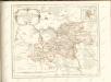

Berlin 60, uit: Special-Karte von Mittel-Europa / nach amtlichen Quellen bearbeitet von W. Liebenow
1 : 300000 titelvariant: W. Liebenow's Mittel-Europa; Annotatie: Titel boven de bladen: W. Liebenow's Mittel-Europa Johannes Wilhelm Liebenow 1822-1897 Frankfurt a. M. : Ludwig Ravenstein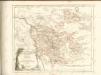

Regiae celsitvdini sereniss. principi ac domino Frieder. Christiano Leopoldo [...] consistorii Wittebergensis tabvlam hanc geographicam svmma mentis pietate consecravit
1 : 250000 Braniborsko (Německo) Vierenklee, Johann Ehrenfried Homannianos Heredes
Regiae Celsitvdini Sereniss. Principi ac Dno. Frider. Christiano Leopoldo Princ. Pol. et Lith. Reg. Princ. Elect. ac Dvci Sax. Dno. Svo Longe Clementiss. Consistorii Wittebergensis Tabvlam Hanc Geographicam Svmma Mentis Pietate Consecravit Svbiectissimvs
1 : 250000 Mollova mapová sbírka Vierenklee, Johann Ehrenfried Homann, Johann Baptista - dědici
Saxonia Svperior.
1 : 350000 Mollova mapová sbírka Janssonius van Waesberge, Johannes Pitt, Moses