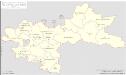
Maps of Steinreich

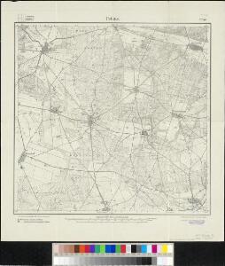
Meßtischblatt 4046 : Petkus, 1942
1 : 250000 Petkus. - Aufn. 1902, hrsg. 1904, letzte Nachtr. 1941, Ausg. 1942. - 1:25000. - [Berlin]: Reichsamt für Landesaufnahme, 1942. - 1 Kt.
Meßtischblatt 2248 : Petkus, 1921
1 : 250000 Petkus. - Aufn. 1902, kleine Nachtr. 1921. - 1:25000. - [Berlin]: Reichsamt für Landesaufnahme, 1921. - 1 Kt.

103. Lübben, uit: Topographische Uebersichtskarte des Deutschen Reiches / herausgegeben v. d. Kartogr. Abt. d. Königl. Preuß. Landesaufnahme
1 : 200000 titelvariant: Topogr. Übersichtskarte des Deutschen Reiches; Annotatie: Titel boven bladen ook: Topogr. Übersichtskarte des Deutschen Reiches; Annotatie geografische gegevens: Op elk blad twee maatstokken: 10 Kilometer = 5,5 cm; 1 geogr. Meile = 3,6 cm; Legenda onder op elk blad Königlich Preußische Landesaufnahme. Kartographische Abtheilung [S.l : Königlich Preußische Landesaufnahme, Kartographische Abtheilung]
Praefecturae principatus querfurtensis Dahmiana et Iüterboccensis cum vicinia oppidis, vicis, pagis accurate distincta
1 : 130000 Braniborsko (Německo) Seutter, Matthäus Lotter, Tobias Conrad M. Seutter
Carte Geographique, ou on fait voir le Dvche de Saxonie nome. le Cercle Electorale :
1 : 110000 Mollova mapová sbírka Homann, Johann Baptist Homann, Johann Baptista - dědici
Karte der Berlin-Anhaltischen Eisenbahn
1 : 200000 Verlag von Simon Schropp & Cop.
Accurate Geographische Delineation Derer Zum Fürstenthum Querfurth gehörigen zwey Aemmter Dahme und Jüterbog
1 : 120000 Mollova mapová sbírka Schenk, Pieter Schenk, Peter II
Praefecturae Principatus Querfurtensis Dahmiana Et Iüterboccensis
1 : 120000 Mollova mapová sbírka Lotter, Tobias Conrad Seutter, Matthäus
Dem Allerdurchlauchtigsten Gros Maechtigsten Fürsten und Herrn Friedrich Augusto Koenig in Pohlen und Churfürsten zu Sachsen
1 : 130000 Mollova mapová sbírka Zürner, Adam Friedrich Schenk, Peter II
Dem Allerdurchlauchtigsten Gros Maechtigsten Fürsten und Herrn Friedrich Augusto Koenig in Pohlen und Churfürsten zu Sachsen
1 : 130000 Mollova mapová sbírka Zürner, Adam Friedrich Schenk, Peter II
Berlin 60, uit: Special-Karte von Mittel-Europa / nach amtlichen Quellen bearbeitet von W. Liebenow
1 : 300000 titelvariant: W. Liebenow's Mittel-Europa; Annotatie: Titel boven de bladen: W. Liebenow's Mittel-Europa Johannes Wilhelm Liebenow 1822-1897 Frankfurt a. M. : Ludwig Ravenstein

Regiae Celsitvdini Sereniss. Principi ac Dno. Frider. Christiano Leopoldo Princ. Pol. et Lith. Reg. Princ. Elect. ac Dvci Sax. Dno. Svo Longe Clementiss. Consistorii Wittebergensis Tabvlam Hanc Geographicam Svmma Mentis Pietate Consecravit Svbiectissimvs
1 : 250000 Mollova mapová sbírka Vierenklee, Johann Ehrenfried Homann, Johann Baptista - dědici
Saxonia Svperior.
1 : 350000 Mollova mapová sbírka Janssonius van Waesberge, Johannes Pitt, Moses
Saxonia Svperior & Hall Episcopatvs
1 : 300000 Mollova mapová sbírka Blaeu, Joan Blaeu, Joan I.
Lusatiae Inferioris Tabula chorographica, secundum statum recentissimum delineata et edita curis
1 : 280000 Mollova mapová sbírka Homann, Johann Baptist Homann, Johann Baptista - dědici
SAXONIA | SVPERIOR, & | HALL EPISCOPATVS.
Amstelædami J. Blaeu excudebat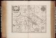
Saxonia svperior
1 : 350000 Annotatie: Origineel is Blad 98 in atlas factice; Annotatie geografische gegevens: Schaalvermelding op de kaart: 2 Milliaria Germanica communia; Rechtsboven binnen kader: XXI; De kaart toont Ober Sachsen met het bisdom Halle, het vorstendom Anhalt en het graafschap Barby Johannes Janssonius van Waesberge -1681?; Moses Pitt ca. 1654-1696; Stephanus Swart [Oxford : apud Janssonio-Waesbergios, Mosem Pitt et Stephanum Swart]
Lusatiae inferioris tabula chorographica secundum statum recentissimum
1 : 290000 Dolní Lužice (Německo) Homannianos Heredes
Lusatiae inferioris tabula chorographica
1 : 290000 Dolní Lužice (Německo) Hübner, Johann Homann, Johann Baptist curis Homannianorum Heredum
Saxonia Superior [Karte], in: Novus atlas absolutissimus, Bd. 2, S. 66.
1 Karte aus Atlas Janssonius Offizin
Das Marckgraffthum Ober und Nieder Lausitz mit seinen abgetheilten Creissen inliegenden Herrschafften Clöstern u: Aemtern
1 : 970000 Mollova mapová sbírka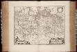
March. Brandenburgici pars, quae Marchia Media vulgo Mittelmarck audit
1 : 400000 Annotatie: Origineel is Blad 91 in atlas factice; Annotatie geografische gegevens: Met schaalstok: Milliaria Germanica Joan Blaeu 1597/98-1673 Amstelaedami : excud. Joannes Blaeu
Totius marchionatus Lusatiae tam superioris quam inferioris tabula specialis in suos comitatus et dominatus distincta
1 : 320000 Lužice (Německo) Hübner, Johann Ioh. Baptist Homann
Totius marchionatus Lusatiae tam superioris quam inferioris tabula specialis in suos comitatus et dominatus distincta
1 : 320000 Lužice (Německo) Hübner, Johann Ioh. Baptist Homann
Totius marchionatus Lusatiae tam superioris quam inferioris tabula specialis in suos comitatus et dominatus distincta
1 : 320000 Lužice (Německo) Hübner, Johann Homann, Johann Baptist Ioh. Baptist Homann
Totius marchionatus Lusatiae tam superioris quam inferioris tabula specialis in suos comitatus et dominatus distincta
1 : 320000 Lužice (Německo) Hübner, Johann Homann, Johann Baptist â Ioh Baptista Homanno
Totius Marchionatus Lusatiae tam superioris quam inferioris Tabula specialis
1 : 330000 Mollova mapová sbírka Homann, Johann Baptista