Maps of Großbadegast

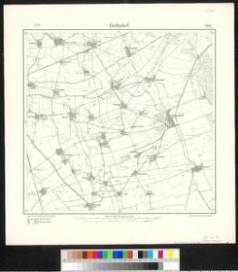
Meßtischblatt 2387 : Quellendorf, 1934
1 : 250000 Quellendorf. - Hrsg. 1904, einz. Nachtr. 1934. - 1:25000. - [Berlin]: Reichsamt für Landesaufnahme, 1934. - 1 Kt.
Meßtischblatt 2387 : Quellendorf, 1904
1 : 250000 Quellendorf. - Aufn. 1902. - 1:25000. - [Berlin]: Reichsamt für Landesaufnahme, 1904. - 1 Kt.
Meßtischblatt 2387 : Quellendorf, 1872
1 : 250000 Quellendorf. - Aufn. 1852. - 1:25000. - [Berlin]: Reichsamt für Landesaufnahme, 1872. - 1 Kt.
Composite: 339. Dessau.
1 : 100000 Reichsamt fur Landesaufnahme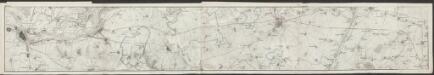
Topographische Karte von der Gegend zwischen Magdeburg, Leipzig u. Dresden, welche die Eisenbahn berührt
1 : 50000 Section 1 Platt, Albrecht Fleischer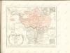

Besondere Land Karte des Herzogth. od. Chvrkreises Sachsen :
1 : 110000 Mollova mapová sbírka Homann, Johann Baptist Homann, Johann Baptista - dědici
101. Dessau, uit: Topographische Uebersichtskarte des Deutschen Reiches / herausgegeben v. d. Kartogr. Abt. d. Königl. Preuß. Landesaufnahme
1 : 200000 titelvariant: Topogr. Übersichtskarte des Deutschen Reiches; Annotatie: Titel boven bladen ook: Topogr. Übersichtskarte des Deutschen Reiches; Annotatie geografische gegevens: Op elk blad twee maatstokken: 10 Kilometer = 5,5 cm; 1 geogr. Meile = 3,6 cm; Legenda onder op elk blad Königlich Preußische Landesaufnahme. Kartographische Abtheilung [S.l : Königlich Preußische Landesaufnahme, Kartographische Abtheilung]
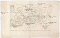
Fürstenthumb-Anhalt
1 : 220000 Mollova mapová sbírka Merian, Matthaeus Merian, Matthäus
MANSFELDIA | COMITATVS
Auctore Tilemanno Stella Sig. Apud Guiljelm. Blaeu.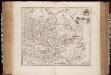
Mansfeldia comitatvs / auctore Tilemanno Stella sig
1 : 170000 Annotatie: Origineel is Blad 99 in atlas factice; Annotatie geografische gegevens: Schaalvermelding op kaart: 2 Milliaria Germanica communia; Kaart toont het graafschap Mansfeld in het gebied tussen Aschersleben, Halle an der Saale, Wiehe Unstruttal en Stolberg Tilemann Stella 1525-1589 [Amsterdami : apud Guiljelm. Blaeu]
Mansfeldia Comitatus [Karte], in: Theatrum orbis terrarum, sive, Atlas novus, Bd. 1, S. 245.
1 Karte aus Atlas Blaeu, Joan Blaeu, Willem Janszoon
Mansfeldia Comitatus [Karte], in: Novus Atlas, das ist, Weltbeschreibung, Bd. 1, S. 162.
1 Karte aus Atlas Blaeu, Joan Blaeu, Willem Janszoon
Comitatus Mansfeldiae Descriptio. [Karte], in: Novus atlas absolutissimus, Bd. 2, S. 75.
1 Karte aus Atlas Janssonius Offizin
Mansfeldia Comitatus [Karte], in: Le théâtre du monde, ou, Nouvel atlas contenant les chartes et descriptions de tous les païs de la terre, Bd. 1, S. 193.
1 Karte aus Atlas Blaeu, Willem Janszoon und Blaeu, Joan Blaeu, Willem Janszoon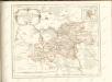
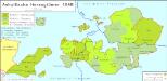
Anhaltische Herzogtümer 1848
Anhalt-Bernburg, Anhalt-Dessau Kunz, Andreas ; Moeschl, Joachim Robert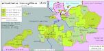
Anhaltische Herzogtümer 1812
Anhalt-Bernburg, Anhalt-Dessau Hundt, Michael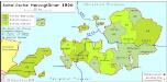
Anhaltische Herzogtümer 1820
Anhalt-Bernburg, Anhalt-Dessau Hundt, Michael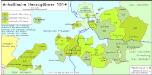
Anhaltische Herzogtümer 1814
Anhalt-Bernburg, Anhalt-Dessau Hundt, Michael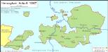
Anhaltische Herzogtümer 1867
Anhalt Kunz, Andreas ; Moeschl, Joachim Robert
Anhaltinus principatus stirpis ascaniensis felicitate hodie florens geographico penicillo descriptus
1 : 235000 Anhaltsko (Německo) Seutter, Matthäus Lotter, Tobias Conrad M. Seutter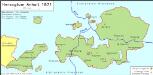
Anhaltische Herzogtümer 1871
Anhalt Kunz, Andreas ; Moeschl, Joachim Robert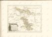

Halle 73, uit: Special-Karte von Mittel-Europa / nach amtlichen Quellen bearbeitet von W. Liebenow
1 : 300000 titelvariant: W. Liebenow's Mittel-Europa; Annotatie: Titel boven de bladen: W. Liebenow's Mittel-Europa Johannes Wilhelm Liebenow 1822-1897 Frankfurt a. M. : Ludwig Ravenstein

Anhaltinus Principatus Stirpis Ascaniensis felicitate hodiè florens geographico penicillo
Mollova mapová sbírka Seutter, Matthäus Lotter, Tobias Conrad Seutter, Matthäus
Fürstenthum Anhalt im Ober Sächssischen Creisse Teutschlandes mit seinen Abtheilungen
1 : 710000 Mollova mapová sbírka Weigel, Johann Christoph Weigel, Christoph I.
Nova Anhaltini Principatus Tabula
1 : 230000 Mollova mapová sbírka Schuchart, Johann Tobias Schenk, Peter I