Maps of Rollshausen

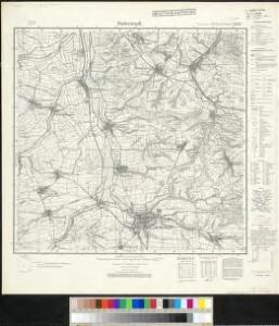
Meßtischblatt 2522 : Duderstadt, 1937
1 : 250000 Duderstadt. - Hrsg. 1910, einz. Nachtr. 1927, [gedr.] [19]34, redakt. Änd. [19]37. - 1:25000. - [Berlin]: Reichsamt für Landesaufnahme, 1937. - 1 Kt.
Meßtischblatt 2522 : Duderstadt, 1878
1 : 250000 Duderstadt. - Aufn. 1876. - 1:25000. - [Berlin]: Reichsamt für Landesaufnahme, 1878. - 1 Kt.
Landgraviatus Hassiae Inferioris Comitatvs Waldeciae Eichsfeldiae Tabvla Geographica
1 : 140000 Mollova mapová sbírka Berger, Daniel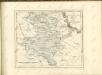

99. Göttingen, uit: Topographische Uebersichtskarte des Deutschen Reiches / herausgegeben v. d. Kartogr. Abt. d. Königl. Preuß. Landesaufnahme
1 : 200000 titelvariant: Topogr. Übersichtskarte des Deutschen Reiches; Annotatie: Titel boven bladen ook: Topogr. Übersichtskarte des Deutschen Reiches; Annotatie geografische gegevens: Op elk blad twee maatstokken: 10 Kilometer = 5,5 cm; 1 geogr. Meile = 3,6 cm; Legenda onder op elk blad Königlich Preußische Landesaufnahme. Kartographische Abtheilung [S.l : Königlich Preußische Landesaufnahme, Kartographische Abtheilung]
Comitatvs Hohnstein
1 : 100000 Mollova mapová sbírka Homann, Johann Baptist Homann, Johann Baptista - dědici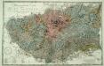
Petrographische Carte des Harz Gebirges
1 : 80000 Lasius, Georg Sigismund Otto; Tischbein, Georg Heinrich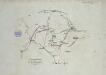
Verproviantirung von Göttingen im Januar 1761

Der Harz
Grosser Hand-Atlas über alle Theile der Erde in 170 Karten Meyer, J. Verlag des Bibliographischen Instituts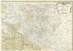
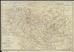
Landgrafiatvs Hasso-Cassellanvs typo geographico quatuor Foliorum expressus Cura Homannianorum Heredum Norimb: 1761
1 : 160000 Mollova mapová sbírka Homann, Johann Baptist Homann, Johann Baptista - dědici
Der Harz.
1 : 103000 Gotthard, A.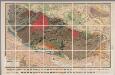
[Kaart], uit: Geognostische Übersichtskarte des Harzgebirges / zsgest. von K.A. Lossen
1 : 100000 Annotatie geografische gegevens: Samengest. naar opnamen van de Geologische Landesanstalt en oudere geologische kaarten, op basis van de Auhagen'sche topographischen Karte 1:100.000 K.A. Lossen [S.l. : s.n.] / ([Berlin : Berliner Lithogr. Institut])
Landt Tafel des Eyßfeldts
1 : 180000 Mollova mapová sbírka Fluck, Johann Merian, Matthäus
Charte von dem Harz Gebirge und einem Theile der umliegenden Gegenden
1 : 200000 Harz (Německo) Julius, Friedrich Berghaus, Heinrich Karl Wilhelm C.W. Ramdohr's Hof-Kunsthandlung
Tractvs Eichsfeldiae in suas Praefecturas divisae nec non Territorii Mvlhvsani Chorographia
1 : 160000 Mollova mapová sbírka Homann, Johann Baptist Homann, Johann Baptista - dědici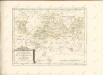
Charte vom Harz
1 : 180000 nach den neuesten astron. Bestimmungen, den besten Charten, Privatzeichnungen, und mehrern eignen Vermessungen und Berechnungen entworfen von I. H. Fritsch [...] 1804 Magdeburg : Heinrichshofen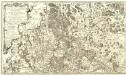
Carte Demi-Topo-Graphique De La Partie Septentrionale du Landgraviat de Hesse-Cassel
1 : 190000 Mollova mapová sbírka Carlet, Louis-François Beaurain, Jean de
Routenkarte
1 : 150000 Dammann, W. Huch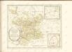

LandtTafel des Eyszfeldts
1 : 180000 Karte des Eichsfelds Flucken, Johann ; Merian Mattäus Merianische Erben
Cassel 72, uit: [W. Liebenow's Special-Karte von Mittel-Europa]
1 : 300000 titelvariant: W. Liebenow's Mittel-Europa; Annotatie: Titel boven de bladen: W. Liebenow's Mittel-Europa Johannes Wilhelm Liebenow 1822-1897 Hannover : Hermann Oppermann
Cassel-Göttingen 72, uit: Special-Karte von Mittel-Europa / nach amtlichen Quellen bearbeitet von W. Liebenow
1 : 300000 titelvariant: W. Liebenow's Mittel-Europa; Annotatie: Titel boven de bladen: W. Liebenow's Mittel-Europa Johannes Wilhelm Liebenow 1822-1897 Frankfurt a. M. : Ludwig Ravenstein
Übersicht der Operationen der Allirten u. Französischen Armee im November 1761, vom Uebergange des Herzogs über die Weser bis zu Ende des Feldzuges
1 : 200000
Special Charte von dem Harz-Gebirge und den umliegenden Ländern
Harz-oblast (Německo) von dem Geographischen Institute
Episcopatus Hildesiensis Descriptio Novissima [Karte], in: Theatrum orbis terrarum, sive, Atlas novus, Bd. 1, S. 194.
1 Karte aus Atlas Blaeu, Joan Blaeu, Willem Janszoon
Le Theatre de Bellone :
Mollova mapová sbírka Schenk, Pieter Braakman, Adriaan
Hassia Landgraviatus
1 : 350000 Mollova mapová sbírka Hondius, Henricus Janssonius, Johannes I
Episcopatus Hildesiensis Descriptio Novissima [Karte], in: Le théâtre du monde, ou, Nouvel atlas contenant les chartes et descriptions de tous les païs de la terre, Bd. 1, S. 137.
1 Karte aus Atlas Blaeu, Willem Janszoon und Blaeu, Joan Blaeu, Willem Janszoon