Maps of Brachstedt

Meßtischblatt 4438 : Landsberg bei Halle, 1942
1 : 250000 Landsberg bei Halle. - Aufn. 1902, hrsg. 1904, bericht. 1940. - 1:25000. - [Berlin]: Reichsamt für Landesaufnahme, 1942. - 1 Kt.
Meßtischblatt 4438 : Landsberg bei Halle, 1936
1 : 250000 Landsberg bei Halle. - Hrsg. 1904, bericht. 1920, einz. Nachtr. 1936. - 1:25000. - [Berlin]: Reichsamt für Landesaufnahme, 1936. - 1 Kt.
Meßtischblatt 2533 : Landsberg bei Halle, 1912
1 : 250000 Landsberg bei Halle. - Aufn. 1902, hrsg. 1904, einz. Nachtr. 1912. - 1:25000. - [Berlin]: Reichsamt für Landesaufnahme, 1912. - 1 Kt.
Meßtischblatt 2533 : Landsberg bei Halle, 1904
1 : 250000 Landsberg bei Halle. - Aufn. 1902. - 1:25000. - [Berlin]: Reichsamt für Landesaufnahme, 1904. - 1 Kt.
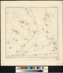
Meßtischblatt 2533 : Landsberg, 1872
1 : 250000 Landsberg. - Aufn. 1851. - 1:25000. - [Berlin]: Reichsamt für Landesaufnahme, 1872. - 1 Kt.
Geographische Delineation derer Aemter Doelitsch Bitterfeld Zörbig
1 : 70000 Mollova mapová sbírka Schenk, Pieter Schenk, Peter II
Descriptio Geographica Praefecturarum Doelitsch, Bitterfeld, Oerbig
1 : 70000 Mollova mapová sbírka Seutter, Matthäus Lotter, Tobias Conrad Seutter, Matthäus
Descriptio geographica praefecturarum Doelitsch, Bitterfeld, Zoerbig
1 : 87500 Bitterfeld (Německo) Seutter, Matthäus Lotter, Tobias Conrad M. Seutter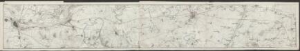
Topographische Karte von der Gegend zwischen Magdeburg, Leipzig u. Dresden, welche die Eisenbahn berührt
1 : 50000 Section 1 Platt, Albrecht Fleischer
Besondere Land Karte des Herzogth. od. Chvrkreises Sachsen :
1 : 110000 Mollova mapová sbírka Homann, Johann Baptist Homann, Johann Baptista - dědici
101. Dessau, uit: Topographische Uebersichtskarte des Deutschen Reiches / herausgegeben v. d. Kartogr. Abt. d. Königl. Preuß. Landesaufnahme
1 : 200000 titelvariant: Topogr. Übersichtskarte des Deutschen Reiches; Annotatie: Titel boven bladen ook: Topogr. Übersichtskarte des Deutschen Reiches; Annotatie geografische gegevens: Op elk blad twee maatstokken: 10 Kilometer = 5,5 cm; 1 geogr. Meile = 3,6 cm; Legenda onder op elk blad Königlich Preußische Landesaufnahme. Kartographische Abtheilung [S.l : Königlich Preußische Landesaufnahme, Kartographische Abtheilung]
Accurate geographische delineatio des Creis Ammtes Leipzig, nebst allen dar angrentzenden Aemtern und Gegenden
1 : 121000 Lipsko-oblast (Německo) Schenk, Pieter Lotter, Tobias Conrad P. Schenk
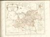
MANSFELDIA | COMITATVS
Auctore Tilemanno Stella Sig. Apud Guiljelm. Blaeu.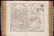
Mansfeldia comitatvs / auctore Tilemanno Stella sig
1 : 170000 Annotatie: Origineel is Blad 99 in atlas factice; Annotatie geografische gegevens: Schaalvermelding op kaart: 2 Milliaria Germanica communia; Kaart toont het graafschap Mansfeld in het gebied tussen Aschersleben, Halle an der Saale, Wiehe Unstruttal en Stolberg Tilemann Stella 1525-1589 [Amsterdami : apud Guiljelm. Blaeu]
Mansfeldia Comitatus [Karte], in: Theatrum orbis terrarum, sive, Atlas novus, Bd. 1, S. 245.
1 Karte aus Atlas Blaeu, Joan Blaeu, Willem Janszoon
Mansfeldia Comitatus [Karte], in: Novus Atlas, das ist, Weltbeschreibung, Bd. 1, S. 162.
1 Karte aus Atlas Blaeu, Joan Blaeu, Willem Janszoon
Comitatus Mansfeldiae Descriptio. [Karte], in: Novus atlas absolutissimus, Bd. 2, S. 75.
1 Karte aus Atlas Janssonius Offizin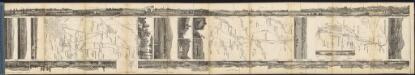
Mansfeldia Comitatus [Karte], in: Le théâtre du monde, ou, Nouvel atlas contenant les chartes et descriptions de tous les païs de la terre, Bd. 1, S. 193.
1 Karte aus Atlas Blaeu, Willem Janszoon und Blaeu, Joan Blaeu, Willem Janszoon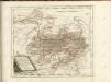

Anhaltinus principatus stirpis ascaniensis felicitate hodie florens geographico penicillo descriptus
1 : 235000 Anhaltsko (Německo) Seutter, Matthäus Lotter, Tobias Conrad M. Seutter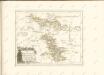

Halle 73, uit: Special-Karte von Mittel-Europa / nach amtlichen Quellen bearbeitet von W. Liebenow
1 : 300000 titelvariant: W. Liebenow's Mittel-Europa; Annotatie: Titel boven de bladen: W. Liebenow's Mittel-Europa Johannes Wilhelm Liebenow 1822-1897 Frankfurt a. M. : Ludwig Ravenstein

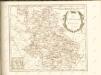
Aucta et Emendata Anhaltini Principatus Tabula
Schnoedt, Karl L.; Püschel, Johann Joachim
Nova Anhaltini Principatus Tabula
1 : 230000 Schuchart, Johann Tobias; Schenk, Pieter Schenck
Anhaltinus Principatus Stirpis Ascaniensis felicitate hodiè florens
Seutter, Matthäus; Lotter, Tobias Conrad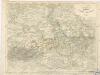
Die Herzogthümer Anhalt, Dessau, Cöthen u. Bernburg