Maps of Iłowa

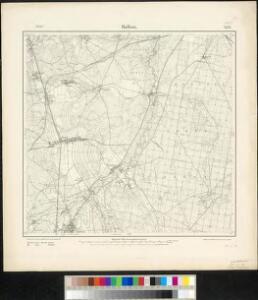
Meßtischblatt 2552 : Halbau, 1905
1 : 250000 Halbau. - Aufn. 1899, hrsg. 1901. - 1:25000. - [Berlin]: Reichsamt für Landesaufnahme, 1905. - 1 Kt.
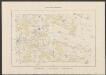
Das Fürstenthum Sagan in Nieder-Schlesien
1 : 280000 Zaháňsko (Polsko) Schleuen, Johann David Schleuen
Das Fürstenthum Sagan in Nieder-Schlesien
1 : 260000 Mollova mapová sbírka Schleuen, Johann David Schleuen, Johann David
104. Guben, uit: Topographische Uebersichtskarte des Deutschen Reiches / herausgegeben v. d. Kartogr. Abt. d. Königl. Preuß. Landesaufnahme
1 : 200000 titelvariant: Topogr. Übersichtskarte des Deutschen Reiches; Annotatie: Titel boven bladen ook: Topogr. Übersichtskarte des Deutschen Reiches; Annotatie geografische gegevens: Op elk blad twee maatstokken: 10 Kilometer = 5,5 cm; 1 geogr. Meile = 3,6 cm; Legenda onder op elk blad Königlich Preußische Landesaufnahme. Kartographische Abtheilung [S.l : Königlich Preußische Landesaufnahme, Kartographische Abtheilung]
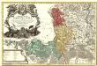
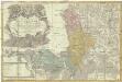
Principatus Silesiae Saganensis in suos Circulos Sagan, Priebus, et Naumburg divisi et
1 : 108000 Mollova mapová sbírka Wieland, Johann Wolfgang Homann, Johann Baptista - dědici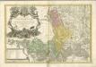
Principatus Silesiae Saganensis in suos circulos, Sagan, Priebus, et Naumburg divisi
1 : 110000 Zaháňsko (Polsko) Wieland, Johann Wolfgang Schubarth, Matthäus Haeredibus Homannianis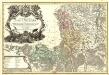
Principatus Silesiae Saganensis in suos Circulos Sagan, Priebus, et Naumburg divisi et.
1 : 108000 Mollova mapová sbírka Wieland, Johann Wolfgang Homann, Johann Baptista - dědici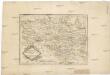
Die Markgrafschaft Oberlausitz in ihre Kreise eingetheilt.
1 : 363000 Horní Lužice (Německo) Hübner, Johann Homann, Johann Baptist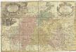
Principatvs Silesiae Schwidnicensis
1 : 128000 Svídnice-oblast (Polsko) Wieland, Johann Wolfgang Schubarth, Matthäus Hered. Homannianis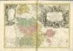

Marchionatus Lusatiae superioris felicissimo Poloniae regis, electoris Saxoniae, sceptro florens, dynastiis et praefecturis suis distributus nova accuratione
Horní Lužice (Německo) Seutter, Matthäus Lotter, Tobias Conrad Matth. Seutteri
Lusatia Superior
1 : 320000 Mollova mapová sbírka Weigel, Christoph Weigel, Christoph I.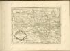

Lusatiae superioris tabula chorographica
1 : 215000 Horní Lužice (Německo) Schreiber, Johann Georg excusa studio Homannianorum Heredum
Lusatiae superioris tabula chorographica
1 : 215000 Horní Lužice (Německo) Schreiber, Johann Georg excusa studio Homannianorum Heredum
Marchionatus Lusatiae Superioris
1 : 180000 Mollova mapová sbírka Seutter, Matthäus Lotter, Tobias Conrad Seutter, Matthäus
LVSATIA | SVPERIOR
Authore | Barthol. Sculteto Gorlitio. [Amsterdam : Joan Blaeu]

Marchionatus Lusatiae superioris felicissimo Poloniae regis, electoris Saxoniae, sceptro florens, dynastiis et praefecturis suis, distributus
1 : 210000 nova accuratione Tob. Conradi Lotter [...] delineatus Tob. Conr. Lotter, sculps. Aug. Vind : Tob. Conr. Lotter
Ober Lausitz
1 : 200000 Horní Lužice (Německo) Schreiber, Johann Georg von Johann George Schreibern
Lvsatia Svperior
1 : 370000 Mollova mapová sbírka Merian, Matthaeus Merian, Matthäus
Lusatiae superioris tabula chorographica
1 : 241000 Horní Lužice (Německo) Schreiber, Johann Georg excusa studio Homannianorum Heredum
Lusatiae superioris tabula chorographica
1 : 241000 Horní Lužice (Německo) Schreiber, Johann Georg excusa studio Homannianorum Heredum
Lusatiae superioris tabula chorographica
1 : 241000 Horní Lužice (Německo) Schreiber, Johann Georg excusa studio Homannianorum Heredum
Lusatia Superior. [Karte], in: Novus Atlas, das ist, Weltbeschreibung, Bd. 1, S. 168.
1 Karte aus Atlas Blaeu, Joan Blaeu, Willem Janszoon
Ducatus Silesiae Glogani

Lusatiae Superioris Tabula Chorographica
1 : 240000 Mollova mapová sbírka Schreiber, Johann Georg Homann, Johann Baptista - dědici