Maps of Schwerte

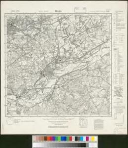
Messtischblatt 2579 : Hörde, 1935 Hörde
1 : 250000 Hörde. - Hrsg. 1894, bericht. 1932, einz. Nachtr. 1935. - 1:25000. - [Berlin]: Reichsamt für Landesaufnahme, 1935. - 1 Kt.
Uebersichts-Karte der Steinkohlenfelder des Rhein-Westfäl. Ruhrkohlenbeckens
1 : 62500 Ostblatt G. D. Baedeker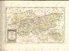

110. Arnsberg, uit: Topographische Uebersichtskarte des Deutschen Reiches / herausgegeben v. d. Kartogr. Abt. d. Königl. Preuß. Landesaufnahme
1 : 200000 titelvariant: Topogr. Übersichtskarte des Deutschen Reiches; Annotatie: Titel boven bladen ook: Topogr. Übersichtskarte des Deutschen Reiches; Annotatie geografische gegevens: Op elk blad twee maatstokken: 10 Kilometer = 5,5 cm; 1 geogr. Meile = 3,6 cm; Legenda onder op elk blad Königlich Preußische Landesaufnahme. Kartographische Abtheilung [S.l : Königlich Preußische Landesaufnahme, Kartographische Abtheilung]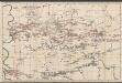
Uebersichts-Karte aller im Ruhr-Kohlen-Gebiet (Rheinisch-Westfälischen-Kohlen-Revier) bestehenden Voll- u. Anschluss-Eisenbahnen, nebst den darin vorkommenden Zechen(Rheinisch-Westfälischen-Kohlen-Revier) bestehenden Voll- u. Anschluss-Eisenbahnen, nebst den darin vorkommenden Zechen
1 : 100000 Königliche Eisenbahndirection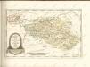

Delineatio Geographica generalis comprehendens VI. Foliis Singulos Principatvs Comitatvs Ditiones Dynastias omnes quotquot Imperio Serenissimi Principis Landgrafii Hasso-Darmstadiensis subsunt :
1 : 180000 Mollova mapová sbírka Bronner, Christian Maximilian Homann, Johann Baptista - dědici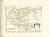
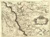
Parte Settentrionale degli Stati dell'Elettore di Colonia
1 : 175000 Mollova mapová sbírka Coronelli, Vincenzo Maria
Comitatvs Marchia et Ravensberg
1 : 270000 Mollova mapová sbírka Schenk, Pieter Schenk, Peter I
Le Comté de la Marck, Les Seigneuries des Abbayes de Werden, d'Essen, et la Ville Imperiale de Dortmundt
1 : 230000 Mollova mapová sbírka Sanson, Guillaume Ottens, Josua
Le Comté de la Marck, Les Seigneuries des Abbayes de Werden, d'Essen, et la Ville Imperiale de Dortmundt
1 : 230000 Mollova mapová sbírka Sanson, Guillaume Jaillot, Alexis Hubert
Archiepiscopatus Coloniensis Pars Septentrionalis
1 : 260000 Mollova mapová sbírka Gigas, Johann Michael
Archiepiscopatus Coloniensis Pars Septentrionalis
1 : 260000 Mollova mapová sbírka Gigas, Johann Michael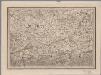
[16], uit: Hydro-Oro und Chorographische General Karte des Koenigreichs der Niederlande und der angrenzenden Länder bis Paris : mit der Angabe der Kunst und Heer-Strassen und der Entfernung der Poststationen / ... zusammengetragen und reducirt von ... Wilhelm Müller
1 : 400000 titelvariant: Generalkarte des Koenigreichs Hannover; Annotatie: 1e supplement bij: Generalkarte des Koenigreichs Hannover (1818) Müller, Wilhelm (fl. 1818) [Hannover : Wilhelm Müller]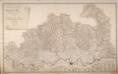
Topographisch-Militairische Karte Des Herzogthums Berg
Wiebeking, Carl Friedrich von; Bechstatt, I. C.
WESTPHALIA | Ducatus
[Amsterdam : Joan Blaeu]
Carte du Comté de la Marck
1 : 160000 Mollova mapová sbírka Le Rouge, Georges-Louis Le Rouge, Georges-Louis

Berge Ducatus Marck Comitatus
1 : 240000 Mollova mapová sbírka Schenk, Pieter Schenk, Peter I
Le Duché De Berg, Le Comté De Homberg, Les Seigneuries De Hardenberg, Et De Wildenborg [Karte], in: Atlas nouveau, contenant toutes les parties du monde [...], Bd. 1, S. 222.
1 Karte aus Atlas Sanson, Nicolas Jaillot, Alexis Hubert und Mortier, Pieter
Westphalia ducatus
1 : 276000 Vestfálsko (Německo) Gigas, Johann Michael Blaeu, Willem Janszoon Guiljelmus Blaeuw excudit
COMITATVS | MARCHIA | ET | RAVENSBERG
[Amsterdam : Joan Blaeu]
Le Comté De La Marck, Les Seigneuries Des Abbayes De Werden, D'Essen, Et La Ville Imperiale De Dortmundt. [Karte], in: Atlas nouveau, contenant toutes les parties du monde [...], Bd. 1, S. 226.
1 Karte aus Atlas Sanson, Nicolas Jaillot, Alexis Hubert und Mortier, Pieter
Le Duché de Westphalie
1 : 250000 Mollova mapová sbírka Sanson, Guillaume Covens, Johannes I
Le Duché de Westphalie
1 : 250000 Mollova mapová sbírka Sanson, Guillaume Jaillot, Alexis Hubert
Le Duché de Westphalie
1 : 250000 Mollova mapová sbírka Sanson, Guillaume Jaillot, Alexis Hubert
Westphalia Ducatus [Karte], in: Theatrum orbis terrarum, sive, Atlas novus, Bd. 1, S. 215.
1 Karte aus Atlas Blaeu, Joan Blaeu, Willem Janszoon
Westphalia Ducatus [Karte], in: Novus Atlas, das ist, Weltbeschreibung, Bd. 1, S. 141.
1 Karte aus Atlas Blaeu, Joan Blaeu, Willem Janszoon